

IWXwx
-
Posts
6,430 -
Joined
-
Last visited
Content Type
Profiles
Blogs
Forums
American Weather
Media Demo
Store
Gallery
Posts posted by IWXwx
-
-
IWX trolling warministas.
SundaySunny, with a high near 89.Sunday NightMostly clear, with a low around 63.MondaySunny, with a high near 89.Monday NightPartly cloudy, with a low around 64.TuesdayMostly sunny, with a high near 89.-
 3
3
-
-
This has been a copy and paste summer in these parts. Today's IND discussion is the latest to paste this:
"An amplified trough/ridge pattern will support northwesterly
flow aloft throughout the majority of the forecast period.
Northwesterly flow may lead to "ridge-riding" mesoscale
convective systems. Models struggle to pick up on the timing
and intensity of MCS features, especially where mesoscale
factors largely determine convective location and intensity.
As such, pin pointing exact timing of any significant round
of convection will be a bit tricky."

-
6
-
-
We had 2.36" of much needed rain overnight. It looks like multiple chances to add on to that this week. We may finally break this abnormally dry weather for awhile.
-
 2
2
-
-
On 8/1/2023 at 9:12 AM, hawkeye_wx said:
I hate drought, but there are two silver linings. I think I've mentioned before that drought knocks Japanese beetle numbers down to very low levels. There have been almost no beetles again this year. The other silver lining is this year's earlier drought has led to my crab apple trees being almost totally free of apple scab. I usually have trouble with bacterial leaf spot on my pepper plants, too, and I think the dryness of the foliage has helped keep the problem in check this year.
I didn't realize that about beetles and drought, but I've noticed a sharp decline in the numbers in my garden this year, so it makes sense.
-
On 7/27/2023 at 11:42 AM, hawkeye_wx said:
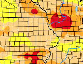
The drought map does not make sense. Over at least the last 30 days, much more rain has fallen in southern Iowa and southern Wisconsin than has fallen here in Cedar Rapids. I've barely received an inch. We've been missed by nearly everything, while Madison has been soaked several times. However, the drought map shows Madison and southeast Iowa in extreme drought while we are only in moderate drought. Even going back 60 or 90 days, we have not had any more rain than the extreme drought areas.
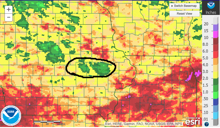
I'm not being a smartass, so bear with me. Join CoCoRaHS and report your daily precip. I've done it since 2006, missing only four or five days. The more reports an area gets, the better the mesoscale/microscale accuracy is in a given location for the Drought Monitor.
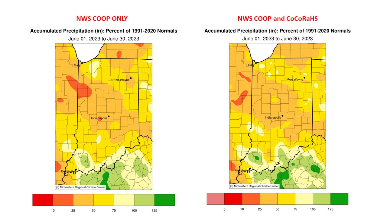
Here is an example of precip reports for June for Indiana with and without CoCoRaHS reports.
I understand that it takes more than you reporting to make a significant difference, but every little bit helps. If all of the weenies here that closely monitor the weather would report, it would make a significant difference.

-
6
-
 1
1
-
-
14 minutes ago, SolidIcewx said:
Don’t know what this rain shower bullshit is out to my west but it can kick rocks. If there is no thunder I don’t want it
I heard two claps of thunder as it rolled through here.
EDIT: Oh...and picked up a whopping 0.03"
-
1
-
-
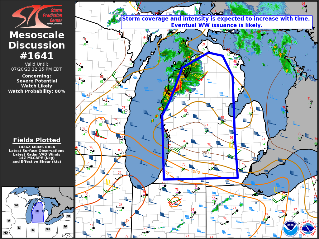
For all of the Indiana posters who are watching the severe threat being pushed father north into Michigan with each model run, IND is throwing out a bone by tossing the CAM guidance. It will be interesting to see what SPC says in their Day 1 update.
Potential for severe weather is increasing for Central Indiana for
this evening and into tonight. Aloft, a shortwave trough, already
evident on satellite imagery in Minnesota, dives southeastward into
the lower Great Lakes region by tonight. At the surface, a
quasistationary NW-SE oriented boundary extends from Southern
Minnesota to Southern Indiana. RAP mesoanalysis data shows a sharp
Theta-E and SBCAPE gradient along this boundary as well as a PWAT
and low level moisture max along and southwest of this line. A
southwesterly 20-35 kt low level jet is currently flowing
perpendicular to this boundary, increasing lift right along it, and
also increasing low level shear to values conducive for organized
convective development. The presence of this sharp boundary and a
related instability gradient, along with mean 850-300mb winds out of
the NW, suggests southeastward storm propagation along this boundary
and into the region. Moist air advection into Central Indiana today
will be aided by both the persistent low level jet today and the
rainfall from earlier this morning, likely keeping dew points and
low level moisture values above what CAMs guidance has been showing
for this afternoon and evening. Latest satellite imagery this
morning also shows high clouds associated with thunderstorm blow off
across much of Southern Illinois and Indiana. These clouds may
further enhance the instability boundary during the day by setting
up a differential heating boundary between the clearer skies further
north and cloudier skies further south.

With all this being said, confidence is increasing in deviating from
short term guidance, which shows the current MCV in Minnesota
pushing towards Northern Indiana and Southern Michigan today.
Additional convective development expected along said MCV. Our
current thinking is that this complex will follow the axis of higher
dew points/moisture and ride along the instability/theta-E gradient
with the mean 850-300mb flow southeastward toward Central Indiana.
Potential is there for additional convective development along and
south of the path of the MCV along the aforementioned boundary within
Central Indiana. While this does deviate from what CAMs guidance is
showing, CAMs did not pick up well on the early morning convection
which will influence the evolution of storms later this afternoon.
CAMs are also notorious for over-mixing the PBL and drying out the
lower levels too much within this type of atmospheric set-up. We
will have to keep a close eye on the track of the MCV to the north
through the day, as its track will be pivotal in determining where
the best severe threat is this afternoon through tonight.
-
19 minutes ago, Powerball said:
Besides the fact that the more recent GFS runs are back to showing a hotter look across the country, He apparently doesn't understand how probabilities work, nor the meaning of "above average"...
He completely understands how probabilities work. He is just playing to his sheep. It is unfortunate that this misdirection is so rampant in the public realm today. Leaders used to work for the betterment of the whole, but no longer.
-
7
-
1
-
-
IWX is hedging their bets on the late week heat. Our point 89's us Wednesday, Thursday, and Friday. lol
-
8 minutes ago, nwohweather said:
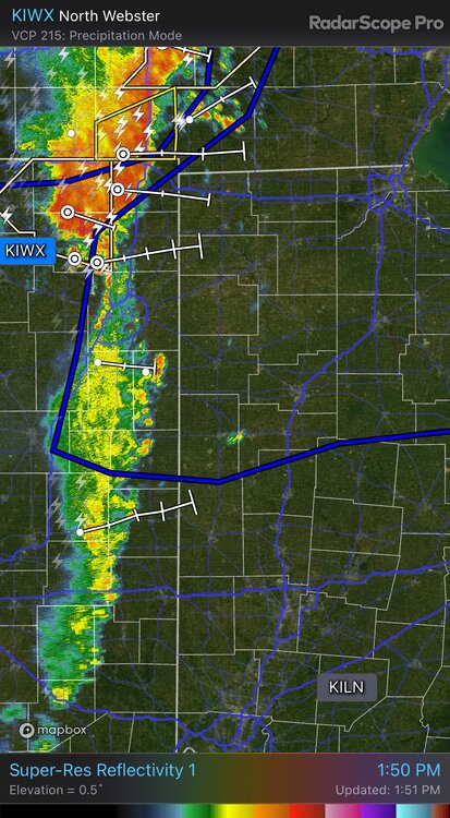
We probably have some tennis ball sized hail right now on that storm in between South Bend & Elkhart
Golf balls are all that have been reported so far, but wouldn't doubt that there are some bigger stones
EDIT: Just had a report of hen egg size (2") in Mishawaka
-
Dropping golf balls east of South Bend and through Mishawaka
-
 1
1
-
-
It's not often that you see an MD for almost the whole mitt and the whole mitt only.
EDIT: Jinx to @Powerball. You just beat me to it

-
2
-
-
TOL, DTW, and FWA area posters might consider making plans to keep their vehicles safely under cover later today (unless you already need some body work.)
-
38 minutes ago, bowtie` said:
Looks like the 6:00p.m. deluge is getting to be a thing here. Day number 2 is about to start. The sky to the north is that horrible bruise color and there is rumbling again.
Just the opposite up here. I'm wishing for some of that storm action, as they keep dodging Huntington. Yesterday, we had one go north, one go south, and one that was zeroing in on town and just disintegrated, leaving us with a DAB.
Today, storms formed along the cool front just to our southwest, which is part of the line you are experiencing.
-
8 hours ago, Torchageddon said:
Insane heatwave in the SW.


Phoenix won't be dropping below 95F/35C for at least 3 days.
"Humidity 4%" wow lol
-
1
-
-
-
11 hours ago, Spartman said:

-
3
-
-
3 minutes ago, Lightning said:
Of course it's 2 counties to my south. Surprise level => 0%
That sounds perfect to me. No risk of structural damage from a tornado to your property, but close enough to chase.
-
The details...
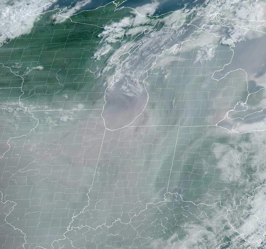
...Northern IL/southern WI east to northwest OH/southern lower MI...

   Current MCS continues a general weakening trend based on IR cloud
   tops, radar trends and recent reports. Air mass recovery in the wake
   of the morning convection currently appears plausible, aided by a
   modestly enhanced low-level jet later this afternoon and evening.
   Steepening mid-level lapse rates will contribute to moderate/pockets
   of strong MLCAPE this afternoon, and coupled with 40-50 kts of
   deep-layer shear would result in a favorable parameter space for
   supercell development by late afternoon/early evening with all
   severe hazards possible. Will introduce a small 5 percent tornado
   probability area across this region, where forecast sounding
   hodograph structure appears most favorable for low-level
   rotation/tornado potential east of a weak surface low.
-
1
-
-
Spinups for Chicagoland and points east? Might have to take a road trip.

-
Caught 1.07" over the past 24 hrs. My yard and garden are loving it. Last night's showers shut down the people blowing up their discretionary spending. Let's do it again this afternoon/evening!
-
1
-
-
2 hours ago, weatherbo said:
Even tho where I live is tucked outta the way and not impacted too much by the influx... I still, strongly dislike the tourists!

Dang!! I'm glad that we went a couple of weeks ago. A big NO to sitting on the bridge like that.
-
1
-
-
I got the summertime equivalent of a DAB, the big T.
-
3
-
-
42 minutes ago, Baum said:
any clue where the action out west is headed?
From the area forecast discussions, there is no consensus. What kind of boundaries/gradient is the current crapvection to the south going to lay out and where?


August 2023 General Discussion
in Lakes/Ohio Valley
Posted
Never gets old.
Sunday