IWXwx
-
Posts
6,593 -
Joined
-
Last visited
Content Type
Profiles
Blogs
Forums
American Weather
Media Demo
Store
Gallery
Everything posted by IWXwx
-

Nov 28-30th Post Turkey Day Winter Storm
IWXwx replied to Chicago Storm's topic in Lakes/Ohio Valley
Crossing my fingers too. I saw your call and if it is onto something, you might have to bring your totals down a little, especially to the south and I would that for you (and me lol). But at least you have warned the public about possible last minute changes since we are riding the edge. So far IWX and you are in pretty good agreement though. -
Nov 28-30th Post Turkey Day Winter Storm
IWXwx replied to Chicago Storm's topic in Lakes/Ohio Valley
@Jackstraw Euro is doin' its thing to us.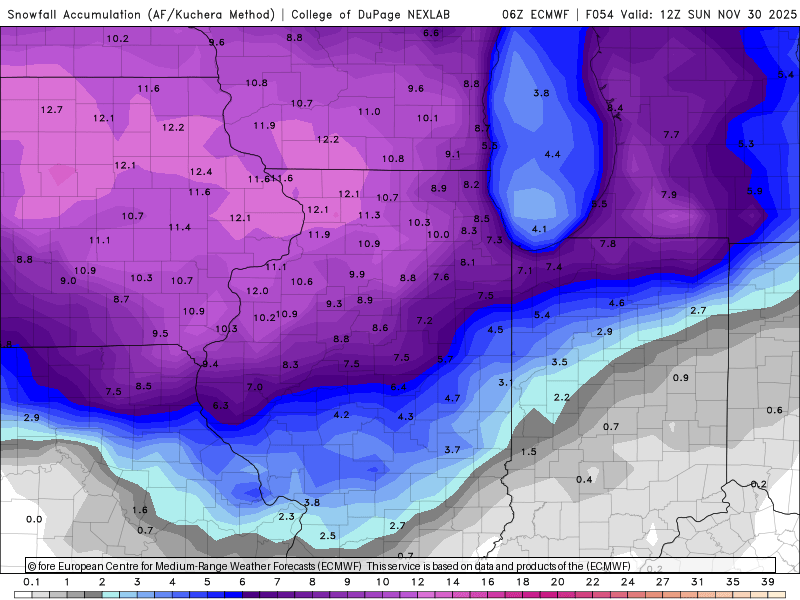
-
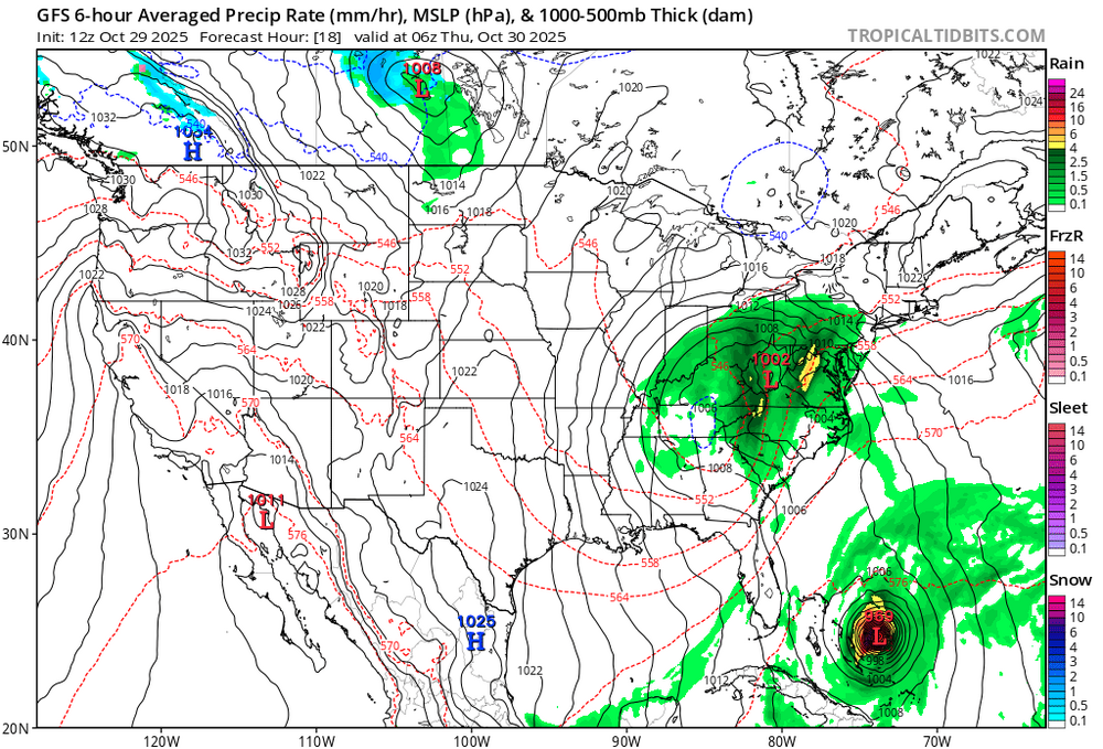
Did you read IWX this morning? Given the incredible thermodynamics, Lake Superior connection, and synoptic support any mesolow or dominant band will be capable of producing snowfall rates of up to 3"/hour with thundersnow quite possible. There is still some uncertainty where exactly the band sets up and how long it stays in one area (models show some variation to the flow through Monday), but snow will be measured in feet, not inches, for any location that sees this dominant band visit for more than a few hours. Have a conservative 6-12" for La Porte County right now but that could certainly go higher. Winds will also be a concern with this event.
-
Euro owned by the GFS
-
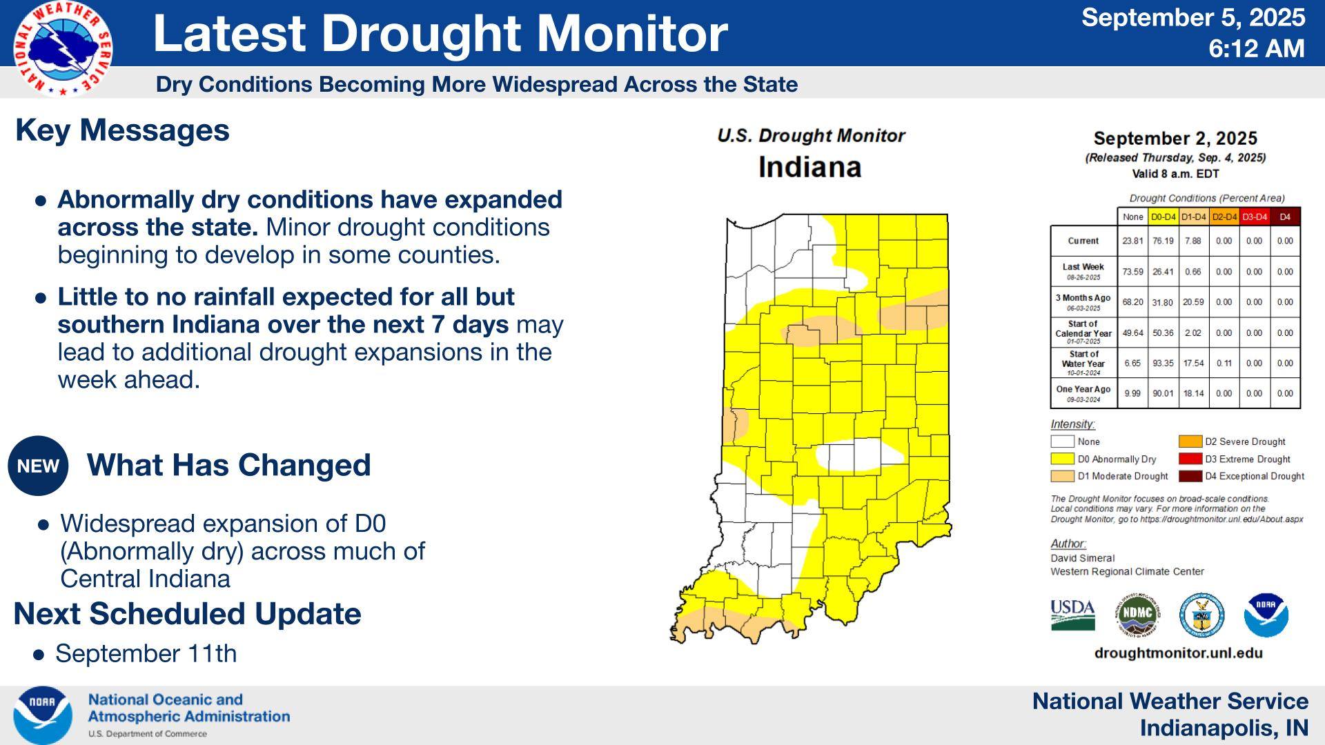
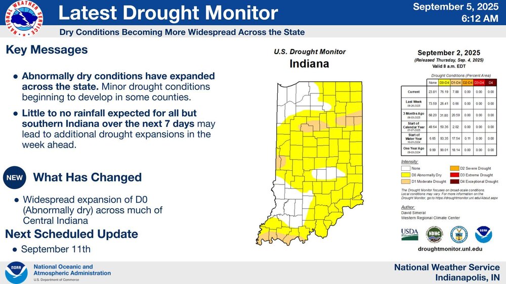
It's gonna take a lot more than 0.06" to break the FWA drought.
-
Thanks guys. I'm sure you're right. I know the soybeans are being harvested, but still quite a few corn fields around here that's still pretty green, but drying rapidly.
-
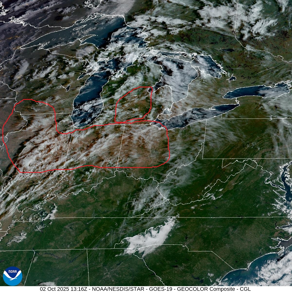
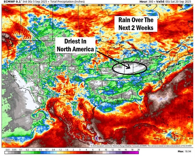
Drought conditions showing up on satellite.

-
Leave it to Spartman to declare summer cancel. Dayton expected 85-90 for the next seven days. A couple of those 89-90’s may be too low
-
Look like they will have the perfect weather for it during the next couple of weeks across our area per the Euro
-
@Jackstraw It's pretty interesting how different weather can be over a relatively small area with similar terrain and elevation. While you eregetting pounded over and over earlier this summer, I'm in drought.
-
My CoCoRaHS gauge caught only .64" in August. Lawn is completely dormant.
-
Do you really want LE rain? Wouldn't you want the lake to be as warm as possible going into the winter season? LE rain in August means that air temps are really cool, which would begin a drop in water temps and lessen the differential as we go into the cool/cold seasons. Asking because I don't know the answer.
-
Unfortunately, I called that one. 935 AM EDT Fri Aug 1 2025 /835 AM CDT Fri Aug 1 2025/ ...AIR QUALITY ALERT IN EFFECT UNTIL MIDNIGHT EDT TONIGHT... The officials at the Indiana Department of Environmental Management have declared an Air Quality Action Day, in effect through today...Friday August 1. An Air Quality Action Day for PM 2.5 has been issued. Fine particulate levels are expected to be in the Unhealthy for Sensitive Groups range. Active children and adults, and people with respiratory disease, such as asthma should limit prolonged outdoor exposure.
-
Yeah, it looks like after the afternoon popups over the next three days, we will be rewarded with some Canadian air, which will be refreshing as long as it isn't accompanied by wildfire smoke.
-
So after I posted our July differences in rainfall yesterday, I got hammered twice last evening, totaling 1.17" of much needed rain. Still a sauna here too.
-
From radar, it looks like you just got hit again. Meanwhile, 40 miles to your northeast, I've had a total of 0.73" in July, with 0.54" on one day.
-
Monsoonal rain here today too. Picked up a quick 3/4". Now the sun's back out.

-
Right?! I had a severe-warned around 6 PM that predictably collapsed before it got here. I can't understand IWX warning pulse storms moving 15 MPH unless they are predicting imminent collapse and an associated downburst. Ended up with 0.04" and a virtual sauna as you mentioned.
-
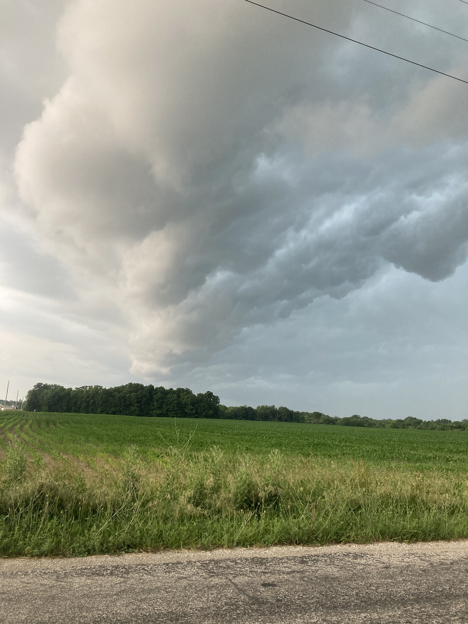
Pretty nice shot of it. I saw that it had a little rotation on the velocity scans. I'm with you on the ROF. Modals showing it staying north, but as has been mentioned here, it usually ends up Coriolising south. If it does stay north, we'll be in the swamp-ass oven for days on end, so pick your poison.
-
@Jackstraw, it looks like you might get lucky as that random storm slides by juuuuuussssst a little to your northeast (using my Bob Uecker voice.)
-
Wow, you're really getting killed by the rain. We had 1.31" yesterday/this morning. We also had a downburst. Lots of trees and powerlines down in about 1 x 4 mile area. I purposely drove into it as I close to it when I saw it on the velocity scan. A tree came down across the road I was on about a minute after I passed it. Here is part of my dashcam video. The first part is the shelf cloud (sped up slightly) and the last part is driving into it. No audio at first and the last couple minutes is me driving into the abyss, to which the video doesn't do justice. Most of the time, I could only go about 10 MPH.
-
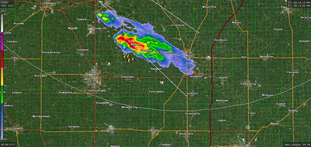
Here's my shelf cloud when it was overhead pic from yesterday

-
Off topic but you are right about expansion north of Indy. I remember when you could drive south to within a mile of 465 and have corn fields. Now it's concrete well north of Westfield and Noblesville, and quickly approaching Pendleton.
-
Wow, quite a difference in a short distance. I've had less than half of that all month.
-
We've had a sharp cutoff up here. As of 7AM, the southern part of the county has had well over 3", and just a few miles north in Huntington, .13"