TheDreamTraveler
-
Posts
939 -
Joined
-
Last visited
Content Type
Profiles
Blogs
Forums
American Weather
Media Demo
Store
Gallery
Everything posted by TheDreamTraveler
-
2024 Atlantic Hurricane Season
TheDreamTraveler replied to Stormchaserchuck1's topic in Tropical Headquarters
12z GFS is pretty wild. Has at least 4 systems develop through the entire run and possibly a 5th storm lol -
2024 Atlantic Hurricane Season
TheDreamTraveler replied to Stormchaserchuck1's topic in Tropical Headquarters
It's possible we get to our S named storm in the next week or two. Maybe the models really weren't wrong about this potentially being hyperactive. Obviously depends if all 3 areas develop but still. -
2024 Atlantic Hurricane Season
TheDreamTraveler replied to Stormchaserchuck1's topic in Tropical Headquarters
And now the global operational 0z GFS just drops the hurricane in the Caribbean completely lol -
2024 Atlantic Hurricane Season
TheDreamTraveler replied to Stormchaserchuck1's topic in Tropical Headquarters
I thought so too. That Hazel graphic really shows how intense and unique of a storm it was. You rarely get a strong hurricane like that that late in the season barreling up the whole east coast with winds that extreme that far inland and north. Though it transitioning also helped the wind speeds too. -
2024 Atlantic Hurricane Season
TheDreamTraveler replied to Stormchaserchuck1's topic in Tropical Headquarters
This season has been one of the weirdest ones I can think of. So many things have seemed out of sync. From the formation of Beryl in late June becoming the earliest cat 5 on record and the strongest storm that far east in the Atlantic that early in the season beating many records. And it went through the graveyard in early July as a category 5. Then things became very quiet. 8/20 through 9/23 which is the climatological peak of the season was the quietest stretch of ACE accumulation since 1994 which is to this day one of the quietest seasons recorded. Then everything that happened with the African monsoon ITCZ during August/September breaking a record for being so far north which was cutting off tropical waves so they could not develop. Now we're in October and suddenly the Atlantic thinks it's early September with three hurricanes spinning at once a few days ago with 2 at the same time both breaking records at the same time being the most powerful hurricanes that far east in October. And I guess we can include how bizarre Milton's track was. Either way it's been a very strange season for sure. -
Seeing this thing still as a category 5 when we're this close to landfall is very concerning. I know it's going to weaken but it really is going to be a nail biter seeing how much it weakens. Intensity forecasts have always been the hardest thing about hurricanes. Forecasting track has gotten exceptionally well over the past 2 decades but intensity still has a lot to work on.
-
Rita was 895mb in the Gulf and is currently the strongest recorded for that area
-
Yep noticed that too. It's been offline the past 10-15 minutes. It's been a while since a hurricane was forecast to take a direct hit on a city this populated.
-
Bigger hurricanes aren't always more immune to negative environmental factors. Sometimes it can be a detriment to their health allowing them to suck in more dry air and experience shear just due to how big they are. Smaller hurricanes can sometimes weasel their ways into smaller more favorable pocketed environments if they're lucky enough.
-
The GFS is just insistent on Milton striking a bit north of Tampa. Every run has had it either north or striking directly so far.
-
The west coast of Florida just can't catch a break the past 3 years with Ian, Idalia, Helene and now Milton. Though Idalia was definitely a lot weaker than people originally thought at landfall at least. I wouldn't bank on any sure intensity ideas until we're a day or two from landfall. Hurricane intensity is the hardest part of forecasting a hurricane.
-
Of course they're only going to go to 155mph lol. Would be pretty wild to see two category 5's this year. Beryl being the earliest that far east and Kirk being the strongest this far east this late in the season
-
2024 Atlantic Hurricane Season
TheDreamTraveler replied to Stormchaserchuck1's topic in Tropical Headquarters
The GFS sure seems adamant on another hurricane landfalling in the same location as Helene multiple runs in a row. Would be absolutely awful if it ends up anywhere close to there. Then take into account Idalia hitting near that same area last year? Crazy. -
Basically the worst case scenario is unfolding and we still have a few more hours to go.
-
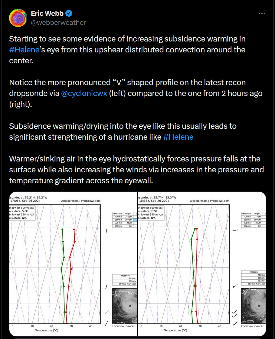
https://x.com/webberweather/status/1839357344716832866
-
I feel like people forget that Helene will still be a strong storm just due to its monster size. Hurricane Ike looked like was a lot 'weaker' when it made landfall but it caused much more damage just due to its huge size compared to a smaller storm of its strength. Helene will be more destructive than a typical smaller hurricane at this category. Just because the wind speeds aren't super high the low pressure and large size/wind field are going to cause much more damage. I feel like people focus way too much on the max wind speed and what category the storm is when there's more that factor into its power and damage overall.
-
The wind field on this thing is absolutely massive. This thing is gonna be a beast in size once it gets built up.
-
2024 Atlantic Hurricane Season
TheDreamTraveler replied to Stormchaserchuck1's topic in Tropical Headquarters
When was the last time we saw a September this inactive, 2014? We still have half of the month to go but things aren't looking too good. Still could change come end of September into October but I'm really starting to doubt a sudden uptick happening anymore -
2024 Atlantic Hurricane Season
TheDreamTraveler replied to Stormchaserchuck1's topic in Tropical Headquarters
Definitely one of the more interesting seasons we've had in a long time. A record breaking category 5 at the beginning of July that smashed basically every single record known to us and then...nothing. Even into the peak of the season where we were forecast to have a very hyperactive season. I'd love to know all the ins and outs in depth of why this is happening. I've read some thoughts on it but I'm sure there's more things. I swear I see people say "oh the waters are warm its gonna be active!!" even though you can have a dead season with record warm waters if other factors don't line up. The atlantic hurricane mechanisms are very deep and varied. -
2024 Atlantic Hurricane Season
TheDreamTraveler replied to Stormchaserchuck1's topic in Tropical Headquarters
It wouldn't be hurricane season without him cancelling the season before it even really starts. -
2024 Atlantic Hurricane Season
TheDreamTraveler replied to Stormchaserchuck1's topic in Tropical Headquarters
These are the same type of people that declare a season dead by the end of July when most storms don't even start forming until mid-late August. The season is not supposed to be super active right now even in a very hyperactive season. They look at the models showing nothing for weeks and declare it dead every single year. It's like people forget seasons can ramp up massively in August. -
2024 Atlantic Hurricane Season
TheDreamTraveler replied to Stormchaserchuck1's topic in Tropical Headquarters
Even the hyperactive record breaking seasons of 2020 and 2021 didn't have what's trying to happen right now with a major hurricane and another trying to form right behind it this far east heading into the Caribbean at the same time in late June/early July. This definitely provokes 2005 and a little bit of 1933 which were massive anomalies. Maybe the ECMWF wasn't hallucinating when it was predicting the most active hurricane season ever since it first went online back in the early 90s -
Central PA Winter 23/24
TheDreamTraveler replied to Voyager's topic in Upstate New York/Pennsylvania
They gave me that exact same time estimation when my power went out a few hours ago. Hoping yours comes back sooner than later. -
Central PA Winter 23/24
TheDreamTraveler replied to Voyager's topic in Upstate New York/Pennsylvania
Lost power here for an hour. Had it flickering off and on repeatedly and I kept hearing a electrical buzzing outside each time it happened. Thank god it came back on just now I was ready for it to be out for a while lol. That snow looks heavy af -
Central PA Winter 23/24
TheDreamTraveler replied to Voyager's topic in Upstate New York/Pennsylvania
You doing okay?