

Heisy
-
Posts
8,369 -
Joined
-
Last visited
Content Type
Profiles
Blogs
Forums
American Weather
Media Demo
Store
Gallery
Posts posted by Heisy
-
-
22 hours ago, 40/70 Benchmark said:
I could see something like that this season. I really like 2000 as an analog, too....prob +3 on my big three list.
One of my favorite winters in Philly. If you’re talking about 00-01. It had an event pretty much every month. Just an exciting winter with the NAO in late December. Dec 30 still the first legit snowstorm I stayed up all night on wxforums. I remember speaking to Ji at like 2 in the AM he was depressed since the skies were clear with a winter storm warning lol.
-
 1
1
-
-
Regardless if we've cashed in on anything yet, it is clear that we're getting off on the right foot with a bunch of threats to track. Beats the hell out of last year.
-
 1
1
-
-
Does anyone have the 00z UKIE beyond 144? @ 144 itself it seems IMO to have the best setup out of all the models (6z GFS/GEFS def shifted S as well)...@ 144 on the UKIE there is also some energy in Canada that looks like it would dive out ahead of the main ULL, helping with confluence and shifting it Southward potentially.
-
If this 50/50 low ends up being legit and we see modeling strengthen it as we get closer it certainly wouldn't shock me to get some front end frozen even into the cities. We'll see if any other models hop on this idea as we get closer.
-
How does second event look? 120 low is in decent position, but I dont have precip
-
Improved ICON look so far @ 108 hrs compared to 6z run. Less phasing going on with that Canadian shortwave. HP in better location
-
1
-
-
11 hours ago, Ji said:11 hours ago, Stormpc said:Was it the 2000 or 2001 bust where Kocin was preaching the loop de loop? Both were epic. I remember going outside Friday night at midnight and seeing a clear sky and full moon after only hours earlier it had clouded up (2000 storm).
That was 2001. After that storm...a month later...to make my depression worse...my company winstar folded and I lost my job
Ji do you remember talking to me on AIM the night of the Dec 2000 bust? You said you were leaving a party and knew it was a bad sign that you could still see stars in the sky....Don’t ask me why I remember that lol....That was the first year I got into wx boards etc. One thing I remember leading up to March 01 was Ji & Noreaster’s (not sure if he posts anymore or has a new username) infamous threads on wright-weather. That storm was a punch in the gut. Who also remembers JB’s newsletter title on Saturday AM before the event?
Anyway, 6z EPS looked colder & showed more CAD for next week’s event, and the day 9-10 thing could make up for it if it ends up being a bust....fun times ahead hopefully.
-
Tell Ji it looks like we also have the JMA in the EURO camp....Who can deny the EURO/JMA team?
-
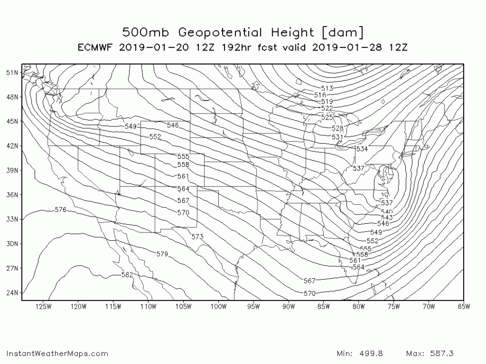
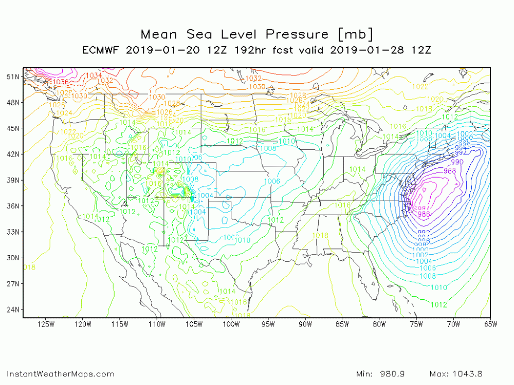
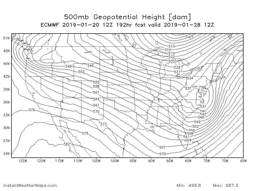
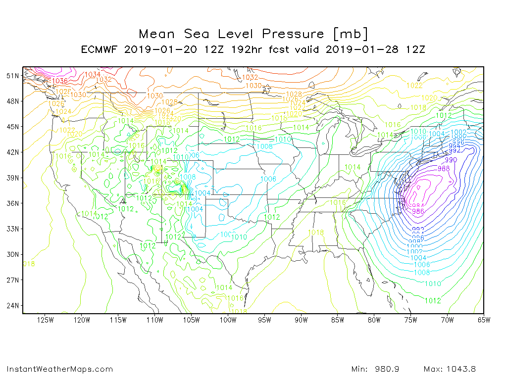
EURO has a nice wedge with heavy snow in the NW burbs, but very close to the cities at 192 hours. Not sure before that.
This is the same event that the FV3 & GFS have...The GFS is warmer while the FV3 is colder (though who could have guessed that).
-
This day 8-9 event has some legs. It doesnt look like it will be a clean event with no 50/50 to keep the low south, however there is good antecedent cold and HP in a great spot. Could certainly see a thump to drizzle type event in the cards if everything works right for us.
-
1
-
-
5 minutes ago, WxUSAF said:
12z 3k NAM initialization is comically bad.
It just goes to show you, we sometimes get excited on a NAM run 48-60 hrs out when it is wrong now WHILE the event is occurring lol
-
Moisture distribution/locationon the models has been really terrible so far for this event in a lot of places IMO, even down in KY/TN...
-
Man, seems to me all the models have done a piss poor job for your location, even the latest HRRR and 12z NAM seem to be not picking up on the heavier precip near DC etc....
-
1 hour ago, C.A.P.E. said:
That Friday deal looks super weak. Might end up just producing very light snow or virga east of the mountains.
True, but with the super cold temps wouldn’t take much QPF to get some accumes
-
Glitter bombs are def a fav type of winter event. Nothing like snow falling with temps at 20 degrees or the upper teens. I think you guys south of MD line could end up with .15-.2” of QPF which could end up being a 2-3.5” type deal if luck holds out.
-
6 minutes ago, wdrag said:
I guess everyone has seen the new 12z/27 GEFS, 12z/27 op EC and 12z/27 EPS (thru 156 hrs). EPS/EC is monitoring for NYC coldest day since 1994 on Thursday with lo/hi of about 0 and ~10F; and maybe...just maybe an inch of snow late Tuesday (EPS prob 20% for more than 1" which is small, while extreme nw Nj and ne PA EPS has 70% chc of more than 3"-Sussex County on the gradient where 70% tends to be less confident). However, out here in nw NJ/ne PA some of the operational guidance is becoming more widespread on 6+ (snow ratio's?) for Pike and Sussex Counties on northeastward into w 1/4 MA. (EPS is less ~4"). Also, am pretty confident of 1 or 2 days (30/31) Chicago top 2 coldest days on record. This is a pretty big event or pair of events, that will exert quite a bit of hardship... infrastructure and 1 or 2 days of cancellations I think here in nw NJ and ne PA, at the least. Also, noticing GEFS has quite a blocking signal beyond 10 days (ne Canada-Greenland) that if occurs, would shunt the initial large warming of the 4th-7th, southward, setting up a battle zone-storm track nearby in Feb (hopefully more favorable than the past two months). No matter, it looks active and interesting but then again, i know its been mostly a dud in Dec-Jan so far for NYC eastward and my enthusiasm is predicated on modeled blocking actually occurring implying, a more snowy-colder favorable -NAO.
Awesome post.
-
1
-
-
14 minutes ago, MN Transplant said:
On the 2nd map you can see why the precip shield isnt as explosive as it could have been. Low is just NE of NC, but look at how widespread the pressure falls are NE of the low. Kind of think of it it like a top spinning (the L) at the end of a pendulum. The Pendulum (trough) is headed E while the energy rounded the base is trying to spin up a low as fast as possible. In a situation like this if the energy rounding the base of the trough cant develop a low fast enough the pendulum just kicks everything NE quickly. Idk....hard to explain without using professional met. Lingo lol....
I’d be curious to see 250-300mb jet during this run.
-
1
-
-
Just now, Ji said:Just now, Bob Chill said:Kuchera. I'd hit 20"+ ytd before Feb. Very tricky setup. We'll get the kitchen sink thrown at us next couple days me thinks

Driest 981 Miller a in history lol
Lol ya, probably because of the fast flow like I said....FV3 looks very similar at H5 but it also has a very tight precip field. Just something to keep an eye on at this point.
I dont have precip, but 216 hrs looks like it was setting up an overrunning event fwiw.
-
500mb looks really nice. The fast flow could end up hurting us though. I’ve been tracking this time frame for a few days now and the one negative we could potentially run into is kicker problems....This looks like a Miller A/B hybrid to me, but idk.
-
Miller B bomb on LR 12z Euro...def some support for this time period
-
1
-
-
Fun times ahead, that is for sure, just be a little patient. The Day 6 event has a shot, but it is an outside shot. Would need initial front and low associated with it to clear as far E as possible. Need good spacing/timing as always.
Regardless, if that fails it is fine, many possibilities after. Honestly, even though Miller Bs tend to be long shots in our region I have always personally favored them over As only because of their explosive characteristics.
Imagine a December 30 2000 event that dug deeper & cut off farther W....It isn’t impossible. Especially if the upcoming pattern is progged correctly.
-
12 minutes ago, jaydreb said:
Lol. Suppression for Panama City. Congrats Orlando?

We’d likely see our shot at a majo event as the PV starts to lift NE obviously & block starts to calm...Heather A event.
-
Right now if I were to guess it looks like there will be some Miller B potential for a week or so after the 24-25th “Anafront” event. Obviously Miller Bs can be mostly misses around DC/Philly, but there was some signal for on the EPS for a low to develop on one of those arctic fronts. If you can get an arctic wave to dive deep enough S you could get a score. However, towards end of month & early Feb we will likely see some legiit shots at a blockbuster event, especially if the progged block ends up developing.
Exciting times ahead. It has been a pretty crap winte here in Philly. Even last night’s event had the heavier stuff stay just Se of the city.
-
3
-
-
Looks like 18z GFS setting up to dump the motherload like the EURO at 162 hours. Huge PNA ridge and the PV is about to be brought Southward

Winter 2020-21 Discussion
in Mid Atlantic
Posted
It just seems we’ll never know the exact answer to that because there are just too many factors. Not only dealing with meteorological, but we have constant changing climate issues as well.