

Heisy
-
Posts
8,369 -
Joined
-
Last visited
Content Type
Profiles
Blogs
Forums
American Weather
Media Demo
Store
Gallery
Posts posted by Heisy
-
-
Models having a tough time with all the moving pieces. If you compare each model with how they are handling the N stream each has their own idea. So many details to iron out. The only people who I think should feel comfortable are the mountains and high elevations of NC, S VA etc because they will certainly get overrunning precip...from there their are so many possibilities we probably wont have a better handle until wed 00z runs, then the rest of the runs to iron out the details, even then could be too soon.
-
Just now, stormtracker said:
Uh, compared to 0z, there was good trends. Meaning, we're not at the final solution yet.
Exactly, and honestly I’d personally just look at the FV3, this old GFS will be obsolete soon.
-
2 hours ago, Ralph Wiggum said:
I like the quasi-Bermuda high that is keeping the lp from moving due east. I dont like how there isn't much hp to the N of the storm. Euro and looks like ukie are going to be relying mostly on dynamics to keep it cold enough for frozen outside of the mountains.
Because the ULL is occluding down south
-
Ukie looks great to me, cmc is a hit, euro fun in an hour?
-
It all comes down to the positioning of the northern short waves and the PV....need to time it where the low comes up the coast right after the front that provides the cold air....
-
Also, dont want to get too wound up into the Dec 8-10th event since I’m starting to feel like this 5th event has legit legs, but the issue I have with it is the timing. If the energy ejected from the SW faster it would be better, but the models right now are taking too long and we lose our cold source.
-
00z EURO looks really good on my freebie maps @ H5 but without precip it is hard to tell...temps are more than fine though.
-
2 hours ago, MillvilleWx said:
EPS control was a pretty solid look with the H5 trough progression cutting underneath, then taking on a negative tilt around our latitude. HP building over the top as the low pressure slides up the coast. This is one way y'all can score in the Day 10, but current progs show that southerly flow ahead of any storm with the retreating surface high initially will cause the thermal layer to have some issues for most of the sub-forum. The overall longwave pattern is ripe for that time frame with a pretty stout H5 closed ULL/trough entering the west coast around Day 7/8 according to the GEFS and EPS 500 hPa Mean. Interesting to note where it also enters the west with the base of the trough rolling through North-Central California. That's a good place to a wave move onshore and exit at or just south of our latitude. A little more south could work as well, but beggars can't be choosers. As many in here have mentioned, the time frame is worth watching. I'll be keeping close tabs on it as well as that system may actually affect our weather out here.
Nice post...Reminds me vaguely of the Feb 5 2010 setup..
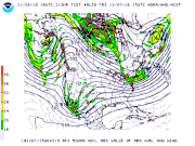
Let me first say though that I am not saying this will turn out to be a similar end result, just noting on the similarities @ H5...Here is the 18z GFS @ 213 hours and then h5 from February 3rd 2010 (2 days before the event)....Note how similar the ULL/trough energy coming out of the Southwest is. What would be key here is to get the N stream to cooperate like it did in 2010.
* I tried posting images but I might be at my max...just going to upload them to an image host....annnd here we go
In 2010, that event that gave you guys a few inches of snow on feb 2-3rd was the catalyst for locking the cold in for main event. Need something similar to happen here for the DEC 8-10 POTENTIAL.
-
 1
1
-
-
FYI for the newbies. Those tropical tidbits snow maps or absolutely atrocious to use in a system like this.
-
Reason EURO shows a wintry event is because it leaves energy behind. The main front clears, gives us our cold shot, and HP builds in. Then the 2nd low comes up the coast....Not saying it won’t happen, but could be the old slow energy bias the euro has.
-
3
-
-
1 hour ago, AfewUniversesBelowNormal said:
I like the 252-300hr timeframe for a snowstorm. Check out the 934mb low. This is probably model feedback for a favorable time period, and could be 980s-990s off the coast.
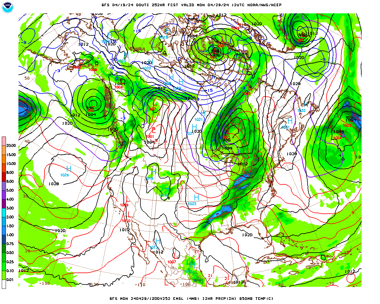
Not sure how that low in Canada being a “feedback issue” would have to do with things. Unless you are coorelating it with a 5050 low? Anyway that image verbatim wouldn’t be good for snow. You don’t get snowstorms in our region with LP banana’d into the lakes and a HP off the coast.
That setup could work in January where you have a parting HP which leads to moisture riding a warm front into CAD. However, verbatim that image you posted is not even close to anything really, especially in Nov.
Dont get me wrong I like the pattern coming up next week, but we would need to really get lucky with timing between short waves and wave lengths etc.
-
22 minutes ago, Wonderdog said:
I would think you would need that Western ridge to be a little further West so that they would be more of a sharper trough in the East
Well yeah, but if what I said was true you’d still get a stronger low to spin up at some point. Like you said though for it to benefit us we’d need other factors.
-
Would need more vorticity on the E side of the trough aka get it to neg tilt.
-
1
-
-
12 hours ago, C.A.P.E. said:
If it were mid December, it would be hard not to like this h5 look with a surface low headed northbound from eastern GA.

I didn’t realize the height pattern looked this good. Massive ULL in a great spot to lock in that cold. This would be server crasher if this was December, heck maybe even late Nov.
-
1
-
-
Man give me this look in December....
-
1
-
-
21 hours ago, Tenman Johnson said:
What are 850’’s?
Mid to late October squalls up there can dump high amounts.
850mb temperature
-
5 hours ago, frd said:
Weeklies
Hmm no surprises , seems cold rest of the month into Nov and then a warm up . After that who knows .....
I know that is temp anomalies, but safe to say looks like the weeklies want to show a +AO by then just based on where those warm anomalies are. Not 100% sure if you can assume heights based on temp anomalies though in that region....Regardless, Idk if Ji posts on here or not anymore, but give me the Dec 5th snowstorm or give me death. Nothing like winter starting out fast. If the weeklies are correct though let’s hope the duration isn’t too bad. Of course I am being sarcastic, I know winter isn’t over by Dec 5th if it hasn’t snowed. Okay, I’ll give it till the 10th.
-
I don’t know, October 2011had that inland snowstorm at the end of the month and that winter sucked. I always seemed to think (and obviously this has no factual evidence) that a cold October lead to warm winters...Weenie that I am.
-
4
-
-
Just want to update to say it’s happened again while logged in just in case that could somehow effect it.
-
Hey guys Ive been staying away from the site for a while now because of the amazon scam pop ups & others. For a while my only source of internet was my phone. I also couldn’t remember my pw or the email that I registered with originally (whoops) which meant I’d have to visit as a guest. About half the time I’d get the pop up which would force me to close my entire browser so I just stopped visiting.
I just bought a new iPad and once again on my very first visit I got the amazon pop up. This is a brand new iPad with no viruses or anything using the standard safari browser.
I was able to figure out my password even though it was tough since the pop up kept happening during the recovery process.
Well see if it happens while I’m logged in I wonder if that would have an impact. Just hope you guys aren’t losing guests because of this issue.
-
Wish I could afford a chase right now. Enjoy it.
-
OT to current obs, but man the last few runs of the GFS, including tonight's 00z really come close to bringing Maria into NJ. Almost boomerangs W before shooting off NE once it is at NJ latitidue.
-
Looks like all of the 00z models across the board really keep Maria OTS thankfully, long way to go though. I remember @ this range when we were still wondering how far N up the E coast Irma would get.
-
CMC brings Maria into the SE Coast, GFS was farther SW, but heads NNE up the coast and out to sea.

December 9/10 Storm
in Mid Atlantic
Posted
This one stings a little because it is generally a textbook look, but we had a few pesky things not go our way. Just a bunch of annoying short waves all over the place. I actually personally feel the 2nd shortwave that misses the phase hurts us by kicking everything East. It would really suck if this was like Late Feb Early March, but we aren’t even thru mid Dec, long way to go of course.