

Heisy
-
Posts
9,030 -
Joined
-
Last visited
Content Type
Profiles
Blogs
Forums
American Weather
Media Demo
Store
Gallery
Posts posted by Heisy
-
-
It’s still snowing outside NE Philly, crazy
-
 1
1
-
-
I ninja’d MJO for once ;). Ukie also looks like it might have done something similar to LR cmc as well
-
1
-
 1
1
-
-
-
9 hours ago, CLIMATE PREDICT said:
As a lover of weather, you owe it to yourself to invest in other things, other than gamestock
 One way to get your feet weight using your love of weather is by trading commodity ETF's such as natural gas. They can be traded at your brokerage firm like Fidelity, etc. For example, since I started telling clients 2 weeks ago about the Polar Vortex, natural gas prices have rallied some 13% in two days; that's not bad considering keeping your money in cash or a money market makes less than 1/2 of 1%
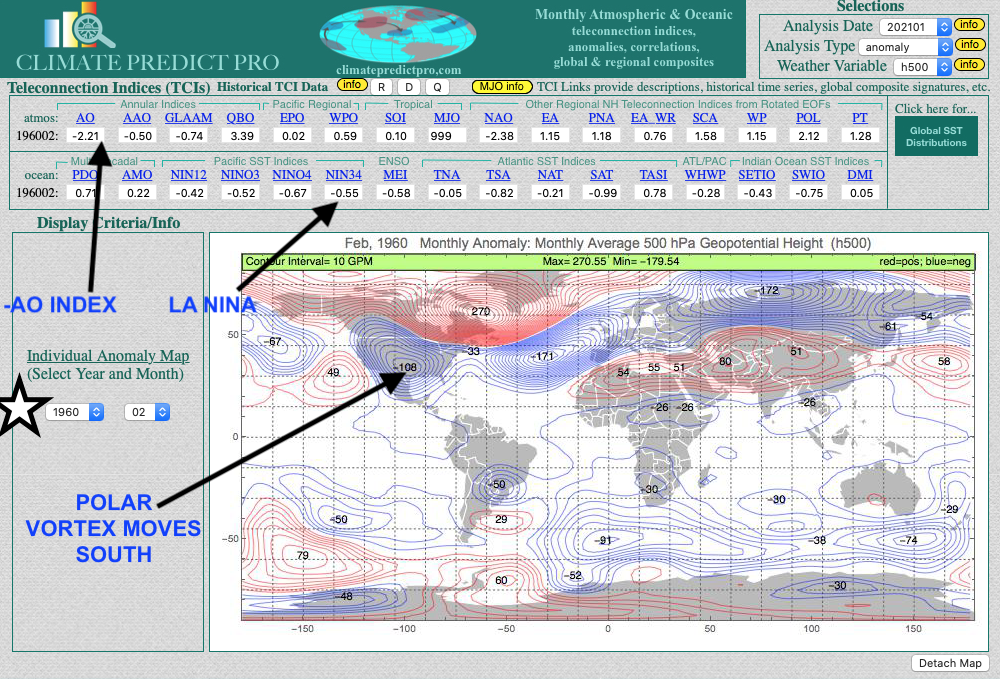
Another major snowstorm is coming to the eastern U.S. this weekend and due to the negative Arctic Oscillation Index. This report here talks a bit more about that and why February and potentially March will be cold https://www.bestweatherinc.com/commodities/how-we-predicted-the-arctic-pig-for-february-setting-the-energy-markets-on-fire/
Funny story I told my dad to buy natural gas. He went to his broker and the guy told him when it comes to that areas he listens to joe bastardi. My dads calls me back, hes like, my broker mentioned some guy named Joe bastard or something do you know of him? I loled. This was back in early Jan when the SSW happened. I bet this continues to rise.
-
26 minutes ago, JakkelWx said:
John pretty much summed up in one tweet what I couldn’t in 58 posts, but yeah, elongate the PV, puts low heights in 50/50 region, hp builds in and roll the dice. Still need to time the branches good as always. Doesn’t garuantee anything, but like playing poker you put your chips in when ahead and should do well in the long run. I told my friend 2 weeks ago that if Philly didn’t get an inch of snow in the next 3 weeks I’d go streaking down Broad Street. I’m not there yet for a similar proclamation, but only because it’ll be a lot colder over the next few weeks and no one wants frozen nips
-
2
-
-
2 minutes ago, psuhoffman said:
I am not putting the kibosh on the Sunday storm, it’s tricky but could happen, but the period after that is a more classic way we score. There will be a pretty extended window after the block retrogrades again and the tpv shifts through the 50/50 to get something to amplify the trough. I would say like 4-5 days. That’s enough time for multiple SWs to have a shot at it. Just need one to break off the tail of the trough and dig into the east to link up with the STJ.
Bingo.
-
2 minutes ago, frd said:
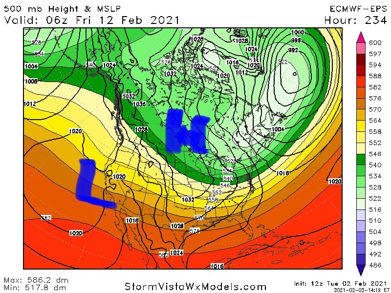
Did you see the almost 1060 High pressure system above Montana at 240 hours in the Euro HI - Res ?
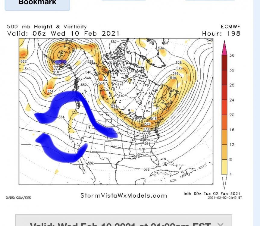
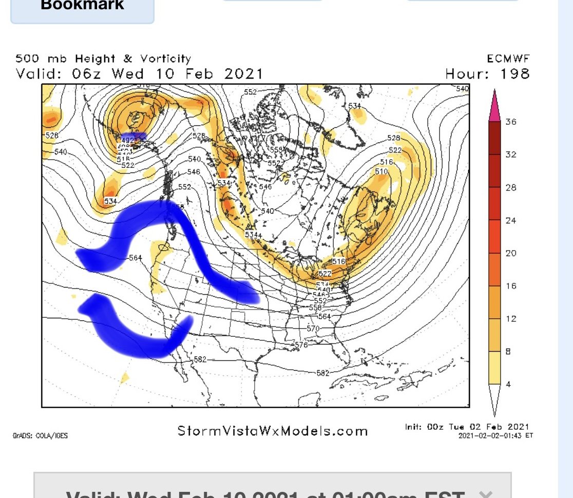
Yes here is eps at same time showing that HP starting to build in. So basically what I’d hope would unfold here is you can see hints of a split flow on the west coast. As the ULL around the lakes head east into 50/50 region it gives room for the Hp to build behind it. Then you have cold airmass in place for whatever comes out west underneath the Rex block. I can’t explain it as well as psu or others but def keep an eye on this time frame. Until then there def a few waves we could score a modest event out of.
-
4 minutes ago, frd said:
Interesting, look out West as well.

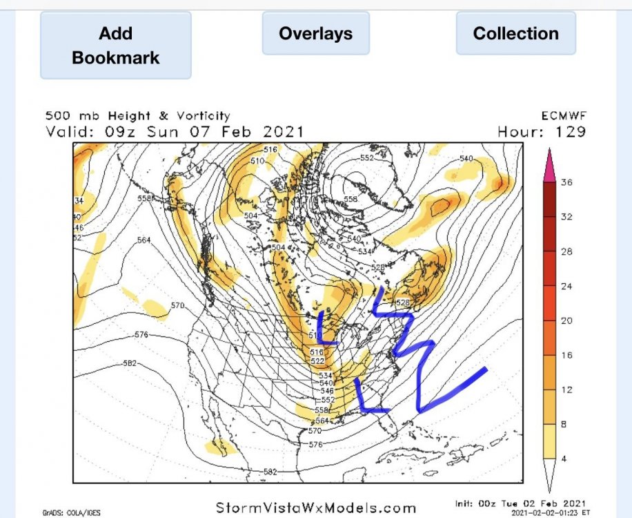
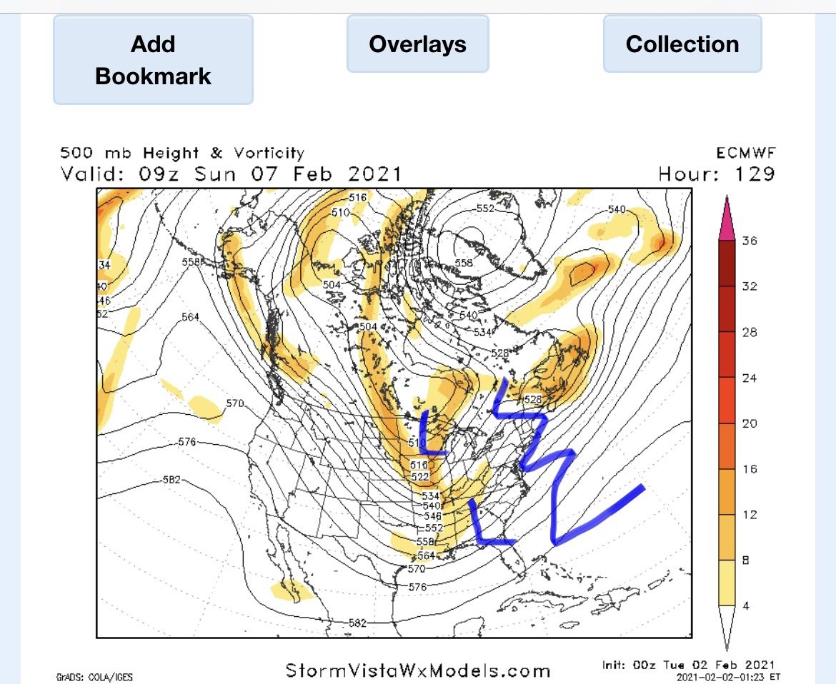
Yeah that’s the Rex block under the -EPO. With a full finished retrograding block. Verbatim the euro has a wave down south there pressed under the NS tpv, but at this range not worried about details. Once that big ULL over lakes would move east if that split flow is modeled right and spacing is good. It’s game on. It’s exactly how blizzard of 96 formed.
does this map look familiar to anyone??
4-5 days before the blizzard of 96
-
5 minutes ago, leesburg 04 said:
Wentz just canceled the back half of February

Haha sorry guys lol. There’s plenty of opportunities before that it just seems this winter the big ones happen at the end of the pattern as -AO relaxes. The fun part is we can rebuilding the -AO.
-
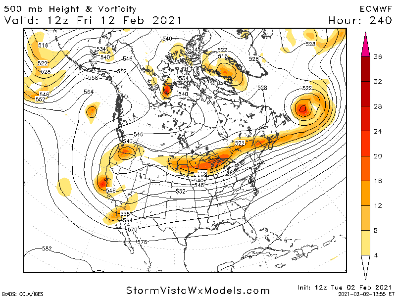
We’ll have multiple shots as the block retrogrades and then a HECS opportunity once the block diminishes for Archambault event feb 10-17. The retrograded block forces low heights out over 50/50 region with potential split flow underneath -epo. This month could be epic if things break right
-
1
-
-
I’m telling you guys whatever happens over next 10 days is gravy. The pattern at the end of euro is HECS potential. We do well at the end of the pattern when it’s about to break down. There’s a split flow setup with lower heights all pressed east into 50/50 region. At this range timing and placement of features is crap, it’s the overall idea you look at. We’re way too far out to know the details but feb 10-17 should have a legit shot at another major event for EC.
-
1
-
-
Hey all! I storm chased up to Dover NJ. Finally got lucky, band stalled over this region all afternoon. Total anywhere from 24-28”, and I’m sure there is isolated 30 spots. Just wanted to see 2 feet somewhere this year and it happened, the rest is gravy.
anywhere, onto the LR
Sunday, the issue with this potential event is that the wave is just an extension of the tpv. This unfortunately could allow HP to slide off the EC and put a low in the lakes. This could still work if the two vorts dive farther SE & with the block this could very well happen.
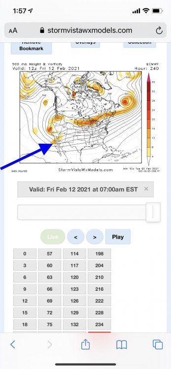
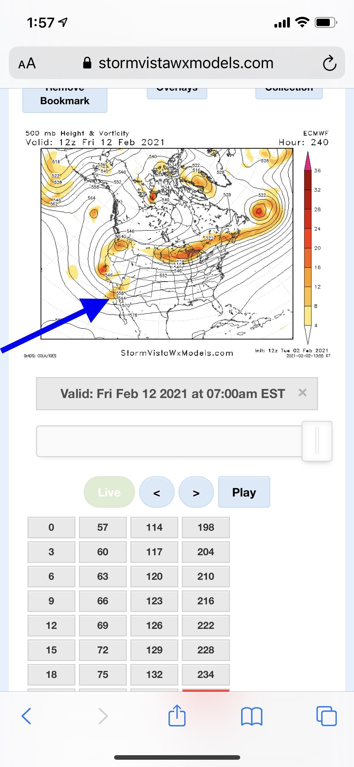
I am highly interested in the day 10-15 time frame. We usually cash as things break down or relax a bit. On this map you can see the block has retrograded. This has allowed a huge 50/50 ULL to form. There’s bit of a split flow out west. What would be important here is if the block retrograded more southwest than due west. If the NS cooperates this has big time potential.
-
5
-
-
30 minutes ago, ForestHillWx said:
I wrote in the interior page, bluewave linked a tweet yesterday from a spotter who measured 24.5” at 4:00 pm. I was finding averages of 22.5” at that time. Since then probably another 2.5-3” with snow falling. Great storm.
Yeah just a complete guess dover id say 25-27 makes sense fallen (maybe more). Otg probably less since overnight with the weight. Those bands currently are just to my west.
-
1
-
-
2 minutes ago, TheSnowman said:
The guy who took the picture in Mendham, NJ with 30”, is a Compact total! Not 6 hours. And that was 8 Hours ago at 7:40pm! It’s been snowing since!
I’m 25 minute drive NNE from there in Dover. I don’t measure so just going off official obs. At 7pm a place 15 mins southwest of me had 25.8. I’m guessing we finish 28-32” here. It’s been snowing lightly all night. This region jackpotted because of a nearly stationary band between like 2pm-6pm
-
26 minutes ago, Ralph Wiggum said:
Snow has not stopped here in Warminster. Had another heavy batch roll thru over the past 90 mins. We are closing in on 12" now. 12k NAM has an additional 2-5" here in Bucks today. Wouldn't be shocked to see that verify. Radar has more backbuilding into the area.
Damn my dad is up near warminster near Davisville/street. Nice hit
-
1
-
-
9 hours ago, Violentweatherfan said:
All I can say is damn is it must be frustrating to be a paid met. Everything was there, how can you go against what the "model consensus"? I'm bummed but not gonna rail against those that share what they learned over the years and posted for us to read that a huge Milller B was gonna shellac us and didn't.
I think a lesson learned for myself and others is h7 pass. Anytime you see the models have an h7 low on top of us you should expect a warm layer to exist. Need it to be farther SE
-
1
-
-
On 1/30/2021 at 1:47 AM, Rjay said:
2nd post in this thread too. Shame we missed the 10 year anniversary.
This is also one of my favorite storms down in Philly. Waa snows overachieved and surprised in the first part and while the gap kind of sucked the main show was incredible with white out conditions for a few hours.
-
Sweet vort pass on last nights euro. Other models sort of backed off a bit but not enough to not be interested. This has a SNE up through NNE look to it. Issue I have with setup is the trough is kind of hooked up back towards Canada. Kind of an extension of the tpv. Would probably be a fast mover but a crusher if this verified.

-
Anyone near dover have latest official measurement? Looks like we will have light snow with moderate bursts through most of the day. My guess is we could get another 1-3” , regardless it’ll make for a very scenic day with 2ft+ on the ground
-
1
-
-
Just now, jm1220 said:
Gravity wave bands SE of Long Island. This one's definitely legit.
I’m legitimately thinking I have a shot to hit 3 feet here. It’ll depend what happens late tonight and Tom if we can add on like 2-3” after this band fades... it’ll be the most snow I’ve ever seen
-
2
-
-
Just now, ForestHillWx said:
Most we’ve had since 2016; it’ll be close if we break it. I had 32.5” in that one. I’m over 25” now. Dover-Chester Road, about 7 miles between the towns.
Keep me posted on our official total. I think this band has a few more hours in it. Then late tonight into tomorrow probably wind whipped light snow so will be close! I’m at the Hilton Dover Rockaway
-
1
-
-
2 minutes ago, jdt said:
I was over 25” two hours ago in Sparta. There will definitely be a 30” total somewhere and perhaps 36”.
The band just reignited, Jesus this Is nuts!
-
Hey guys, I finally may jackpot a chase, or close to it. Currently in Dover NJ. I’ve been sitting in the south end of this band all day. It refused to move west of me. It’s been 8 years coming since I made my first chase up to MA for feb 2013. With what’s left has to be a chance for 30-35” I just don’t know what type of rates we see overnight/tomorrow. I also don’t measure so just going off official nws measurements.

-
3
-
 1
1
-
-
I’ve been getting a stalled ccb band train through here all afternoon. I left Allentown late day yesterday to come to Dover. Probably wouldn’t have mattered, but I may end up over 30”


January 31-February 2, 2021 Major Winter Storm Observations
in Philadelphia Region
Posted
It’s not impossible though, where I was in NJ a band parked itself on me. I was literally probably 10 miles away from being too far S