

Heisy
-
Posts
8,369 -
Joined
-
Last visited
Content Type
Profiles
Blogs
Forums
American Weather
Media Demo
Store
Gallery
Posts posted by Heisy
-
-
You guys think I should stick with Williamsport or maybe head east to Scranton or south towards Harrisburg. I can’t freaking decide
-
 2
2
-
-
So many factors. Where does the low tuck to? Rgem/euro types almost have it to Baltimore. Lol. Then you add how quick does it deepen. 3km would be best case it really imo. Still undecided on Williamsport maybe Scranton or down in Harrisburg. On my search for the jackpot haha
-
3 hours ago, DHS@ABE said:
On December 14th New Jersey had 4,800 new COVID cases with a population of 9 million, Pennsylvania had 9,500 cases with a population of 13 million, Florida had 8,500 cases with a population of over 21 million.
Florida currently has about 1/2 the COVID cases that the Northeastern US states do. The recent fatalities mimic the same pattern.
Enjoy Florida! Restaurants, schools and bars open. Masks are optional. Less COVID.
Do you get your facts from oann?
-
 1
1
-
 2
2
-
3
-
-
24 minutes ago, MAG5035 said:
Unless your already booked up in Williamsport, since your leaving early in the morning I'd have a good look at 0z and 6z guidance to make sure the swath of excessive snowfall is still going through there directly. A couple backup options might be State College, somewhere up US 15 between Harrisburg and Willamsport (Selinsgrove-ish) or Lewistown on the US 322 corridor that goes between Harrisburg and State College... although I think any of those options are looking pretty good at the moment haha.
All those places have pretty good roads so I would imagine they'll be reasonable by Thursday evening since this is supposed to end by daybreak Thur. If they aren't, well then you probably picked the right place for your snow chase haha.
CTP mentioned about CSI banding in their discussion, that's the kind of setup you could easily get thundersnow or certainly very intense snow rates out of.
And lastly, I'm still on the fence with these Jan 2016-esque totals that persist on model guidance. Within what looks like pretty much an area wide 10-20", I certainly think at least a thinner stripe of 2'+ is possible anywhere between I-99/220 and I-81 depending on where these intense bands set up. These bands are likely to have better temps aloft in the snow growth layer to boost snow ratios being located in the central part of the state. A 30" is doable, but that would be one heck of an experience to get there since this looks like about a 15-16hr storm.
Lol the NAM is now making me think poconos would be better lol
-
Idk if anyone remembers my posts from 2-3 days ago saying the best part of this storm for the city will be the thump. That still holds true now.
Heisy’s call:
center city: 2–4” followed by sleet then grapple/drizzle mix during dryslot..maybe some bursts of snow at the end that doesn’t amount to much
northeast philly: 3-5” same deal
Good luck down here I’ll be up in Williamsport!
-
1
-
2
-
-
Hey folks. I’m headed to Williamsport early tomorrow morning. I’m beyond excited haha...couple questions
1) looks like the storm ends early tomorrow. How are the roads up my way? I should be near an interstate. I drive a car not a truck/suv. Think I may be able to get out Thursday night?
2) how’s the instability looking up this way? I’d love to experience some thunder snow.
3) my goal is 18” I think the duration will hurt a bit. I think the snow maps are a bit overdone because of it, but who knows. Do you guys think someone my way might hit 30?!
-
Anyone have a link to the RPM?
-
5 minutes ago, Allsnow said:
7pm
Starts rolling on stormvista at 645, get your game up
")
-
1
-
1
-
-
Haha I know right. I’m so worn out I couldn’t handle another 7 day track.
-
1
-
-
Hello active December...verbatim it misses, but gotta love the potential gfs showing for Christmas Day or day or 2 later....Hell of a ridge out west, if you space out the waves properly that’s dynamite. I’m headed to Williamsport pa btw. Good luck up there this go around. Philly will get one this year
-
2
-
-
What a setup haha... real close this run
-
25 minutes ago, ryanconway63 said:
That's a powerful cold front on the Euro for Christmas Eve
It reminds me of the December 2000 cold front that had epic thunderstorms and setup a nice pattern that lead to the dec 30 event. Of course that was a bust west of philly, but pattern does look good. It’s better than missing this storm and looking like crap.
im chasing to Williamsport Pa. at this rate the best forcing will end up NW of even me
-
49 minutes ago, Ji said:
lol philly is a terrible snow town. Id rather live in Wincehster
Yeah idk what he means by that. We’re just as bad as DC pretty much.
-
GFS at 189 hours looks interesting with the setup
-
2
-
-
CMC almost looks like the maps it had with this storm at day 10
-
To brighten the mood check day 7 gfs. Not bad with that energy coming down from the northwest. I can’t even fathom tracking another event right now though lol
-
1
-
1
-
1
-
-
Why you guys even consider the GFS is beyond me. As a veteran model watcher it always jumps the gun at the 36-48 hr stage. ALWAYS. I only use it for determining if a storm has potential in the medium range. Specifics are a joke. Look at 12z run for more reality.
-
1
-
-
3 minutes ago, Topher said:
Hey, I’m also chasing this storm(from dc area). Very familiar with the selinsgrove, Williamsport area so hoping those two will be in the max area. Would just be happy with 12-15”+.
Awesome! Sent you a pm.
-
Hey all. I’m chasing this storm up from Philly. I don’t want to drive more than 3 hours tops. I was thinking either poconos, but also Williamsport or around the Harrisburg region. Any spots you’d recommend based on current data? I’m a little worried in E PA about the deformation zone lifting farther N than anticipated, but that’d still be better for c pa. Can’t decide! I’d be leaving early tomorrow morning so still time to get some model runs in.
-
1
-
-
We’re going to have plenty of opportunities. This one is tough to swallow for cities point SE, but it’s only mid December. Can tell already this winter will produce.
-
5
-
3
-
-
1 minute ago, Birds~69 said:
GFS...jogged E a bit?

It’s total unsupported crap. CMC is well north 00z
-
8 minutes ago, Animal said:
Pulled from New England 18z euro
safe to say phl get hit hard..liking 10 on my street. Heavy precip beats marginal temps Imop
Overdone. It’s gonna be sleet with a lp sitting there in Philly. Let’s make a bet. Haha btw I might go to Jim Thorpe like you said
-
Just now, qg_omega said:
What a cave to the GFS, we have a new King
It’s one run and a qpf tick Upper air features are fine. Idk man it could be worst you could be in Philly with hours and hours of sleet
-
 1
1
-
-
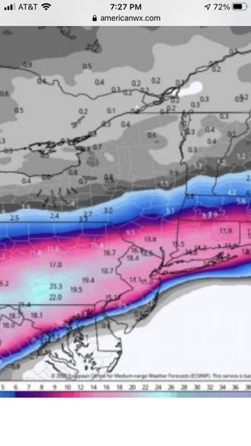
2 minutes ago, wxeyeNH said:
Here is the comparison of 12Z and 18Z Euro runs. 10:1 ratio

I’m headed to either Hershey or like Jim Thorpe. Gonna get mauled over there hopefully.
-
1
-

Active mid December with multiple event potential
in New England
Posted
How much for philly?