

marsman
-
Posts
722 -
Joined
-
Last visited
Content Type
Profiles
Blogs
Forums
American Weather
Media Demo
Store
Gallery
Everything posted by marsman
-

2024 Atlantic Hurricane Season
marsman replied to Stormchaserchuck1's topic in Tropical Headquarters
Good little spin off the coast of Miami. Visible on satellite, appears to be drifting north into a lower shear area. -
The capacitor in my Davis station has gone out (again) so I'm without obs till I get a new battery. The outside obs I do have is the maple in the front yard is dropping leaves like it's early October.
-
56.5 for a low at 6:50am. Forecast to be cooler tonight. Windows open kinda nights!
-
High of 92.5 at 3:20pm.
-
After hitting 90 yesterday, 63.9 this morning at 5:40 and airing out the house.
-
Hurricane Debby - flooding rain threat region wide
marsman replied to olafminesaw's topic in Southeastern States
5.57" from Debby. -
Hurricane Debby - flooding rain threat region wide
marsman replied to olafminesaw's topic in Southeastern States
Up to 3.30". Temp at 76 and dewpoint at 75 - very muggy, the older windows on the house are condensing. -
Hurricane Debby - flooding rain threat region wide
marsman replied to olafminesaw's topic in Southeastern States
WRAL: 1 fatality in Wilson. 2.97" and counting so far after only .41" yesterday. -
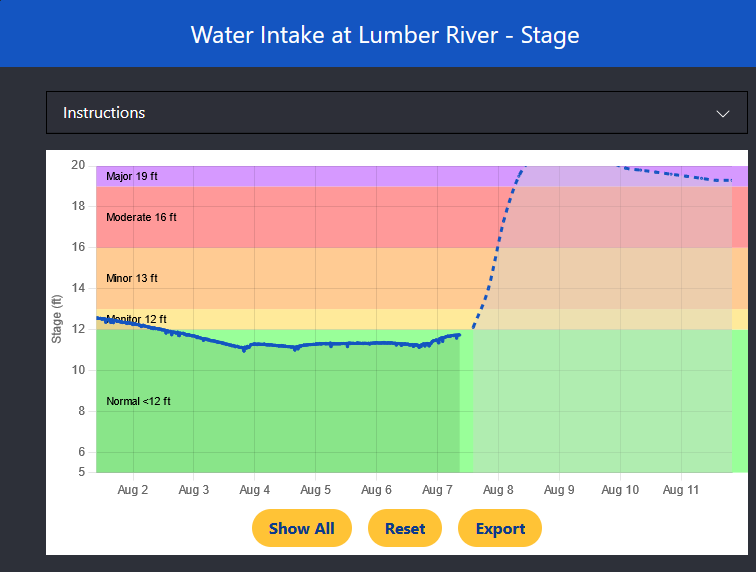
Lumber river forecast off the chart:
-
75 for a high yesterday with intermittent showers after the first heavy band. Only got 0.55".
-
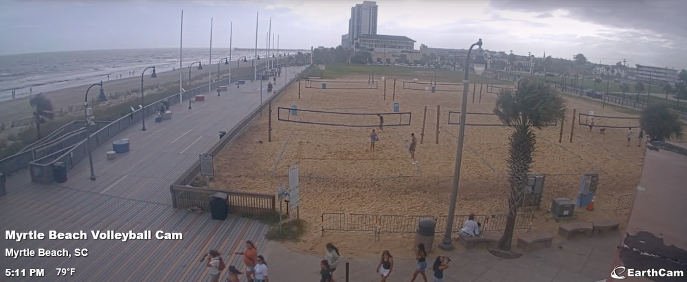
Brandon's got a vortex on the ground in N Myrtle Beach: https://www.youtube.com/watch?v=uRKjp8Vzoow
-
Volleyball too.
-
Ft. Myers Beach earlier today.
-
I don't think I've ever seen a 90 degree turn on an NHC forecast map. Anyone?
-
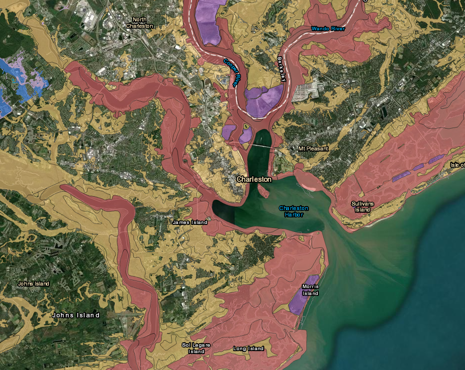
SC Flood map (FEMA MSC doesn't allow to zoom way out) https://scfloodimpact.com/Index
-
Even if it tracks further west over GA, I see it stalling for a time around 32-34N or off the SC coast. Lotta rain.
-
In the July obs threat there was talk about RDU's temperature being higher than what others were reporting. WRAL did a story on it: https://www.wral.com/story/degrees-of-separation-what-s-behind-temperatures-taking-off-at-rdu/21521863/
-
99.7 at 3pm today.
-
July wrap up: High of 101.9 on 7/5 Low of 57.8 on 7/2 Precip: 9.44" 4x 100F+ days on 7/5, 7/6, 7/14, and 7/15
-
TRDU and KRAX showing red on RadarScope. Down for anyone else? RDU looks like it's getting poured on right now.
-
Up to 8.46" for the month, 7th consecutive day with rain.
-
Mowed for the first time in 3+ weeks yesterday. .83" over the past three days. Nothing yet so far today. Surprising 5.95" for the month to date, nearly half of that coming from July 6th.
-
0.0" yesterday. I'd also be in that .01" spot. There's even a little gray section of less than that.
-
96.4 at 5:10pm. Storms in the area creating a breeze.
-
1.71" for yesterday. Serious condensation on the house this morning, even on the new windows.


