

marsman
-
Posts
722 -
Joined
-
Last visited
Content Type
Profiles
Blogs
Forums
American Weather
Media Demo
Store
Gallery
Everything posted by marsman
-
Was a pleasant early morning with temps in the upper 60's! Stayed just below 90 today with a high of 89.6 at 5:40pm.
-
This weekend's disturbance may already be causing problems east of Raleigh. The line that came through RDU last night stalled to the east, Flood Warnings up from Greenville south to Kinston, no strangers to flooding there.
-
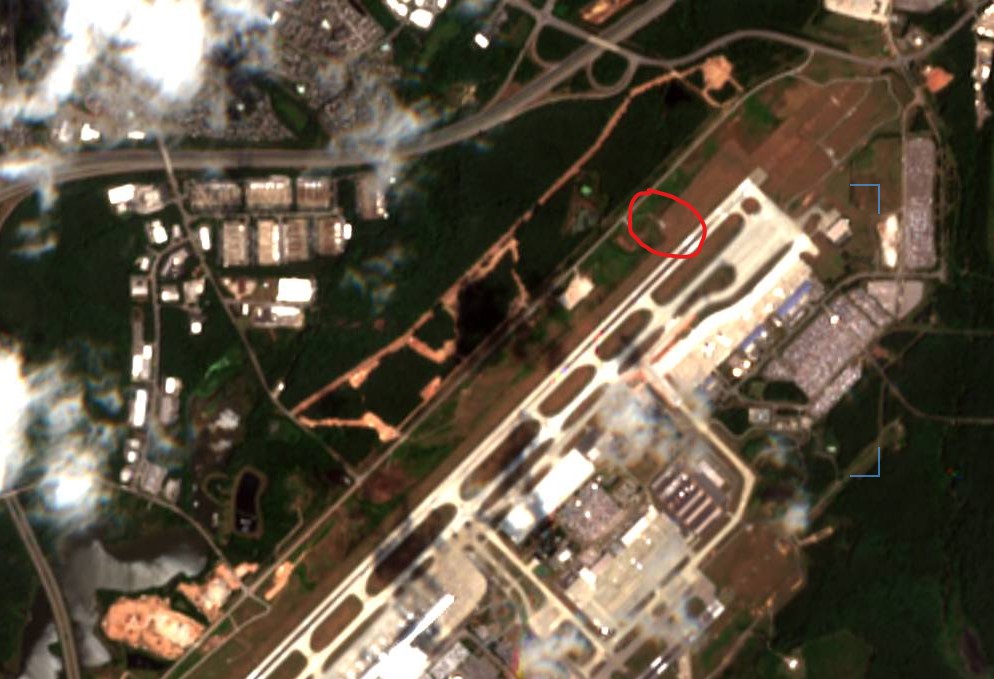
Going back to my comment about runway construction at RDU, here's a sat photo from 06/08. Compared to the Google Maps satellite photo, there is some significant tree/forest removal going on in the area. The station is circled in red: For what it's worth I recorded 101.9 for a high on 07/05.
-
I was in Maine for the first week of July so I'm delayed on the monthly wrap-up. I needed a sweater most nights/mornings, but that's all I'll say. June totals: Rain: 1.00", .26" of that was from 6/30. 20 days without rain. High: 100.9 on 06/26 Low: 49.1 on 06/01
-
The new runway is also going up right where the station is. I wonder if anymore vegetation has been removed or if there is any construction equipment nearby.
-
 Barbados radar: https://www.barbadosweather.org/Radars/LeafScripts/BMSRadarProducts.php
 -
Not counting yesterday's trace, day 19 of no rain. 96.3 at 1:20pm today. Yesterday turned out to be a "pleasant" 87 for a high, even did a little garden work. I look at my lawn and say "look how they massacred my boy..."
-
Trace of rain this morning, didn't even register on the station. Only enough to move the dust/dirt around and increase the humidity.
-
100.9 at 2:40pm. Max Heat Index was 118 at 2:34pm.
-
97.8 yesterday at 5:50pm / 75.8 at 4:40am. Day 14 here with no rain.
-
High of 96.6 at 5:10pm. Still 90 at 7:30pm.
-
92.5 yesterday. The parts of the lawn that see full sun are pretty much gone.
-
2024 Atlantic Hurricane Season
marsman replied to Stormchaserchuck1's topic in Tropical Headquarters
NHC lemon'ed it: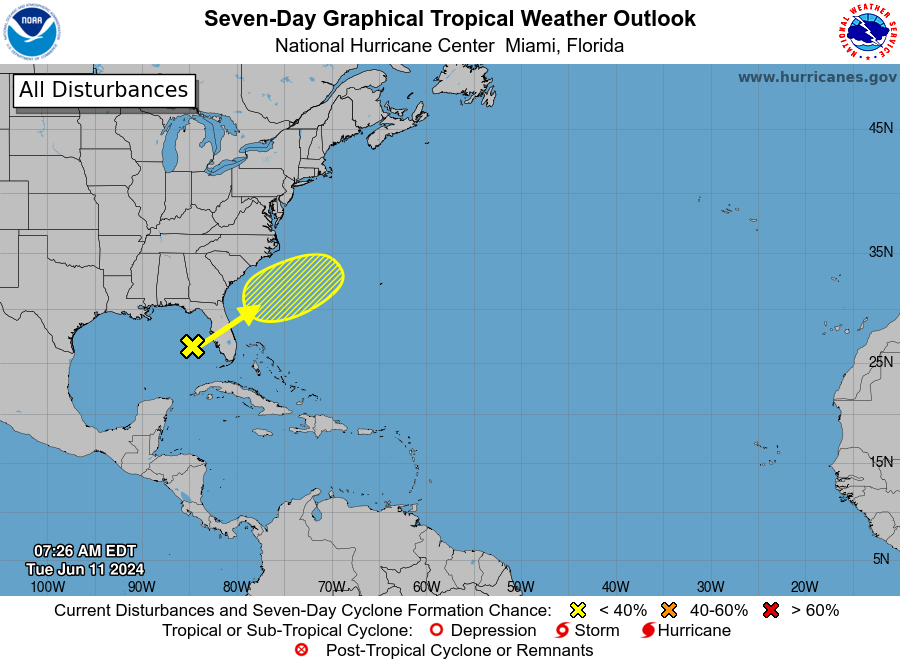
-
High of 90.9 at 6:11pm. Still 88 at 7pm!
-
Picked up 2.15" yesterday. First 1+" since April 3rd.
-
90.6 at 1:05pm. No rain so far, doubt we'll see anything from the storms to the SW impacting the CLT area.
-
87.2 for a high at 5:10pm today. Picked up .11" from the passing storms last night, great for the garden.
-
91.1 yesterday at 2pm. No rain from passing storms, but a lot of smoke came through in the afternoon. Sky was orange for a bit. Didn't hear anything about a wildfire anywhere.
-
High of 93.3 at 5:31pm.
-
High of 91.2 on 4/15. Low of 36.7 on 4/23. 1.42" of rain for the month.
-
78.4 at 4:37pm.
-
Whopping 0.01" of rain today. 1.2" for the month, most of which came down on the 3rd. Hopefully we'll get something on Sunday to get the garden going and wash away the pollen. Meanwhile, in Dubai.....
-
88.8 at 3:47pm. Hit the same on Apr 2.
-
First 90+ of the year - 91.2 at 4:44pm.
-
Rain total from yesterday's storm stayed at .01" Fantastic morning to have the windows open if you can handle a little dust and pollen, low of 58 at 7:30am. Might see the first 90+ of the season next week.

