
marsman
-
Posts
648 -
Joined
-
Last visited
Content Type
Profiles
Blogs
Forums
American Weather
Media Demo
Store
Gallery
Everything posted by marsman
-
NHC will initiate advisories on Potential Tropical Cyclone Sixteen, located offshore of the southeast coast of the United States, at 1100 AM EDT (1500 UTC).
-
Been watching Mount Washington's weather, might be the most interesting thing going on. Currently showing winds at 72mph, gusts to 82 and 38F. Clouds are ripping across the summit.
-
52.2 for a morning low at 6:45am. May be awhile before I see this again.
-
I found this to be a great pictorial and graphical article: Hurricane Florence 5 years on - Collaboration of NWS Morehead City, Raleigh, and Wilmington: https://storymaps.arcgis.com/stories/c77c7dd5e79b406581168c8073a08060
-
57.1 for a low this morning at 7am.
-
This morning: 1.74" from the storm coming through, flash flood warning up for parts of Wake county.
-
94.2 at 12:53pm and .44" of much needed rain, last recorded rain was on 31 August. edit: also some small hail.
-
Same here, RDU is about 2-3 degrees above my readings. High of 97.4 at 2:45pm.
-
Recon is airborne.
-
Calling it - high of 100.1 at 4:55pm.
-
High of 99.2 at 4:58pm
-
.41" from Idalia. Small twigs in the yard, no problem for the lawnmower. Hoping to go below 60 the next two nights and maybe even have a fire!
-
Heard from my family in Valdosta - text only, FaceTime and voice calls aren't going through. Homes are destroyed.
-
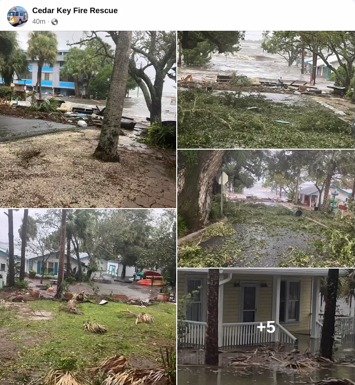
Cedar Key: https://www.facebook.com/CedarKeyFireRescue/posts/pfbid0VLw563P9r7HYiuMRWhjbSUit4TWGeucmDUeeg3C28oNcWhyHuG1CiVpbqZRAr5Jdl

-
I have family in NW Valdosta, they're reporting flooding and some road closures. They still have power, but are in a newer development and not really in a rural area.
-
Family is reporting flooding in Valdosta.
-
Another Tornado Warning for the Marco Island, FL area, this one until 2pm. edit: another one just north, covering most of the Collier County coast. earlier the local news station was on scene in Ft. Myers Beach, i would say about 6-10" of water on the roads.
-
Tornado Warning FLC021-291615- /O.NEW.KMFL.TO.W.0017.230829T1547Z-230829T1615Z/ BULLETIN - EAS ACTIVATION REQUESTED Tornado Warning National Weather Service Miami FL 1147 AM EDT Tue Aug 29 2023 The National Weather Service in Miami has issued a * Tornado Warning for... Southwestern Collier County in southwestern Florida... * Until 1215 PM EDT. * At 1146 AM EDT, a severe thunderstorm capable of producing a waterspout located 11 miles south of Cape Romano, or 17 miles south of Marco Island, moving north at 40 to 45 mph. HAZARD...Tornado. SOURCE...Radar indicated rotation. IMPACT...Expect damage to mobile homes, roofs, and vehicles. Tree damage is likely. * Locations impacted include... Marco Island, Cape Romano, Key Marco and Goodland. PRECAUTIONARY/PREPAREDNESS ACTIONS... TAKE COVER NOW! Move to an interior room on the lowest floor of a sturdy building. Avoid windows. If you are outdoors, in a mobile home, or in a vehicle, move to the closest substantial shelter and protect yourself from flying debris. && LAT...LON 2598 8184 2600 8162 2581 8159 2581 8161 2578 8165 2578 8171 2593 8183 2597 8184 TIME...MOT...LOC 1546Z 163DEG 39KT 2569 8165 TORNADO...RADAR INDICATED MAX HAIL SIZE...0.00 IN $$ Baxter
-
99.6 at 4:05pm - the highest of August so far. 10 days with no measurable rain.
-
96.6 at 3:20pm. Not bad considering the calls for 99+ earlier this week.
-
50's showing up for lows in the RDU area late next week. Maybe... maybe I can actually enjoy an Octoberfest with some October-ish temps.
-
5pm advisory out. They'll likely be strong currents and waves for the east coast coming up. Already seeing 6-10' wave forecasts offshore OBX.
-
98.2 at 2:39pm
-
Yesterday: RDU hit 100, but it only got to 96.5 IMBY. .22" of rain, enough for the garden. 68.9 this morning before the drive in to work, felt amazing, windows were down.
-
Yesterday's high was 79.3F, only saw 0.06" of rain. Not enough for the garden, especially with the temps in the coming days. 8/3 was even cooler, 77.8F for a high.