

madwx
-
Posts
2,362 -
Joined
-
Last visited
Content Type
Profiles
Blogs
Forums
American Weather
Media Demo
Store
Gallery
Everything posted by madwx
-
got 1.62" here today. Really helping stave off the drought.
-
Foreshadowing a summer of 89s in Dayton
-
ended with an average temp of 49.2 here. 2.7 degrees above average. 25th warmest April. Only 1.44 inches of precip, over 2 inches below average and 24th driest on record
-
Only rained imby once since April 11. Need some rain and need it quickly before things start going off the rails in terms of drought
-
like @cyclone77 lots of dust devils in open fields today. the dry air is allowing for some impressive mixing
-
you may find yourself, sitting under a polar high
-
Nice little NW flow wave moving through here this afternoon. Already some lightning strikes near La Crosse
-
I'm 29. Got Pfizer, first dose was a sore arm and dry mouth. Second dose was a sorer arm and general fatigue and a headache, nothing bad but felt tired for about a day or so.
-
so there's been talk of lack of severe weather in the spring in the Midwest so I decided to look at number of Severe Thunderstorm Warnings issued by Milwaukee by April 30 each year: 2021: 0 2020: 8 2019: 3 2018: 3 2017: 26 2016: 2 2015: 12 2014: 14 2013: 3 2012: 4 2011: 24 2010: 10 2009: 3 2008: 14 2007: 11 2006: 21 2005: 29 2004: 10 2003: 0 2002: 29 2001: 6 2000: 19 So no huge trends but we've definitely been in a drought recently for severe weather in the spring. 2002-2011 was really a boom time for early spring severe
-
severe thunderstorm warning in NE Wisconsin right now with sfc temps around 40 degress
-
warm front mixed n of here in the past hour. Jumping from the upper 50s to the low 70s. Gonna make a run at 80 today
-
front crashed back down through the area this evening but should shift back northward tomorrow morning.
-
Up to 72 here. Big win for the HRRR today with temps.
-
The WAA precip moved through here earlier, but luckily it was warm enough throughout the lower atmosphere for it to be all rain
-
Both the NAMs changed drastically and now have the warm front getting hung up at the WI/IL border tomorrow with highs only around 60 tomorrow, meanwhile the HRRR blasts the warm front N and gets us into the low and mid 70s. Past climo tells me the NAM will be correct about this but with the dry air and efficient mixing, I wouldn't be surprised to see the warm front mix fairly far northward
-
interested way to think about people having medical issues after vaccines. With half of the adult population in the US having at least one vaccine so far, it makes it absurdly easy to draw the connection between a vaccine and some kind of ailment since logically tons of people out of that 50% vaccinated are going to have some kind of medical issue during the past 4 months. It would be like saying people are getting sick/dying/etc. after going to Thanksgiving Dinner with family. Just by the sheer number of people doing it of course there will be people with health issues afterwards, even when it's not connected
-
The MJO is moving into phases 8-1-2 which is an active weather look for the central US in the spring
-
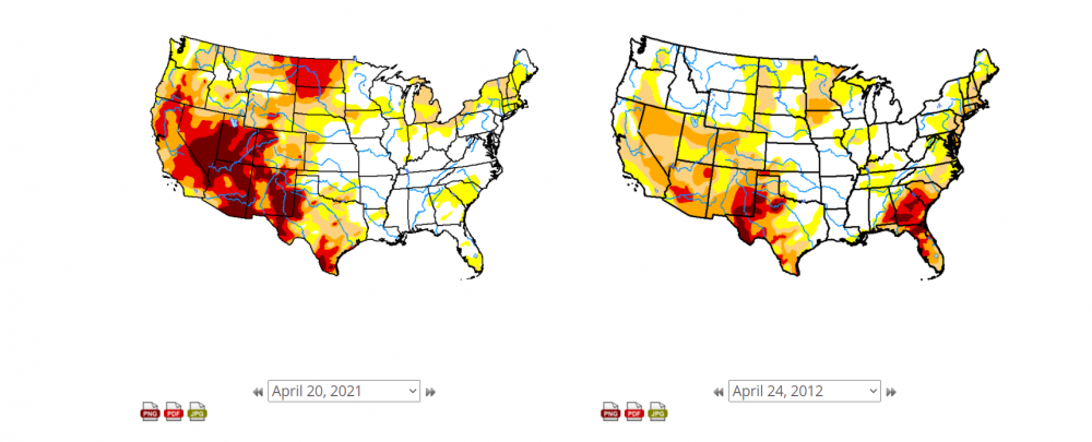
We're actually significantly worse than 2012. At least for areas W of the Mississippi.
-
Getting close to our last freeze here. Tonight is a slam dunk and Saturday night has the potential but then a warm stretch is upcoming and climo starts working against us
-
Visibility below a half mile in this squall. these things mean business. Accumulating on the grass/part of the sidewalk
-
already getting some convective snow showers this morning. Very ominous look in the NW sky
-
Latest measurable snowfall on record for Paducah Kentucky
-
Yeah I had a bad take. I’m willing to admit that
-
thats fair. Wasn't really thinking about south of I80
-
Texas has been a very middle of the road state in terms of Covid deaths per capita. Not as good as Florida(!) or California but not nearly as bad as Alabama and Mississippi.


