

madwx
-
Posts
2,362 -
Joined
-
Last visited
Content Type
Profiles
Blogs
Forums
American Weather
Media Demo
Store
Gallery
Everything posted by madwx
-
going to be a not so good 48 hour stretch starting tomorrow morning. two cold rainy days with temps in the 40s and a serious frost potential friday night
-
only a couple hundredths here. need this upcoming soaker to keep holding off the drought
-
now do the part where you read the rest of his sentence.
-
think a lot of people will have a chance at convection sunday with the cold front crashing SW
-
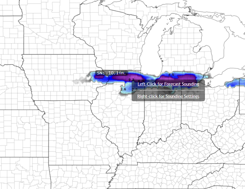
almost time to get the snow machine cranking again
-
Madison had 6 70 degree days during the same stretch. Pretty crazy
-
the boost in protection and long lasting antibodies is well worth any illness you feel after the second shot. It's also far from guaranteed that you will feel bad after the second shot, some just get a sore arm and feel tired.
-
definitely think there will be a few severe chances in the upper midwest over the next week
-
only got down to 36 here this morning. No frost that I could see
-
There is a large trough over the central US right now that is pushing the jet stream to the south making Texas and the SE the preferential spot for storms
-
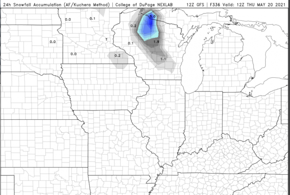
the aformentioned NAM run. Kuchera totals
-
Correct, the maximum north latitude it will track is around 41.5 degrees north. That is its path over the 3 hour period it is expected to reenter, with the best estimate reentry time in the middle where the satellite icon is. The blue is the track before the expected reentry and the yellow is the track after the reentry time but still in the window
-
it changes very rapidly. For example it's now expected to reenter about a half hour earlier which would mean it impacts in the pacific ocean. Each horizontal dash on the yellow/blue line is five minutes in time
-
https://twitter.com/AerospaceCorp I've been using this site to track the predicted landing spot. Obviously there are many dynamics at play that we can't measure and being off by 30 mins means it could reenter about 1/4 of the globe away. but it will most like be somewhere along the yellow or blue lines in this image around 10 pm Central tonight, with the best guess of the N Atlantic right now
-
the real disappointment is that the clouds from this system are going to ruin my Chinese rocket debris views tonight
-
wagons definitely south on this one
-
3KM NAM wants to give us snow showers with a shortwave on Monday. The ride never ends
-
won't be surprised with some upper 20s here as well. looks like a couple more nights with frost potential on sunday and monday nights
-
MKX mention a rain snow mix in passing in their AFD but didn't say much about it.
-
its all fun and games until I realize this subforum is just me, Hoosier and Spartman's 89 sock puppet accounts.
-
eh temps are really marginal so it doesn't really accumulate. In the end I think this will trend to rain
-
This will ruin my Vitamin D intake. Sad
-
don't worry, it gets better.
-
hydrate a lot beforehand. get comfy and find some good movies to watch. also be prepared for the chance that your symptoms are much milder because that can be the case, especially for people who've already had covid.
-
the great Mount Tambora eruption of 2014


