

madwx
-
Posts
2,362 -
Joined
-
Last visited
Content Type
Profiles
Blogs
Forums
American Weather
Media Demo
Store
Gallery
Everything posted by madwx
-
Actually overperformed by a few degrees today up to 25.
-
getting some cumulus popping up here for the first time in a while.
-
also vaccines are very very good at preventing severe illness so at that point any vaccinated person should have no fear at getting anything more than a mild illness even if they do get infected
-
The forecasted cloud cover the past 2 days has been a bust here. Full sunshine now after some mid level clouds this morning
-
He also predicts cold weather will last through the last week of March. Which I will press X to doubt
-
Winter is holding me hostage and I'm Stockholm Syndroming pretty hard rn.
-
Overperforming today, already up to 17 under filtered sunshine. It seems like the full cloud cover won't be rolling in until the evening
-
pretty crazy temp rise this morning as the inversion broke, 20 degrees in the past 3 hours and 15 degrees in the past 2 hours.
-
Down to -14 so far this morning. 2 away from the record low. Got one last major radiational cooling night on Friday night
-
Radiating very well tonight. Down to -5 already
-
We've had the 6th coldest first 15 days of February here with an average temp of 3.7 degrees. The only comparable stretch in recent history is 2007 which had an average of 4.4 degrees but ended the month at 14.4.
-
walked outside in a t shirt and full sun and 16 felt alright
-
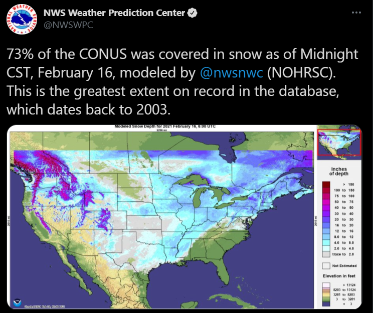
This is the greatest snow cover extent since at least 2003.
-
up to 9 degrees and full sunshine. Feels like a heatwave outside. Will finally be able to melt some of the snow and ice that's been stuck on the roads
-
Got slightly higher today with 73.6% snow coverage. Thinking this should be the max
-
Got 0.4” here on the far NW edge of the snow shield
-
Some N/S oriented gravity waves showing up on MKX radar
-
finally popped above 0 here. Between 8 pm Friday and 3 pm Monday we only had 1 hour above 0.
-
Kuchera is actually really simplistic. You just take the max column temp below 500 mb, subtract it from -2 celsius and add it to 12. So for example if the max column temp was -12 celsius, you would do 10+12 so 22:1 ratios.
-
up to 70.4% of the country covered in snow. Have a chance of passing that tomorrow, depending on how much melting(if any) occurs in Texas
-
waiting for the official number but looks like we got down to -12 or -13 this morning. Just short of the record again. We just had the 7th coldest first half of February for MSN. Looking forward to the slow climb out of this now. The cold has overstayed its welcome.
-
One positive around here is that the consistent snow cover has lead to a fairly shallow frost depth. So when we do warm up the ground won’t stay frozen for long and will be able to soak up water
-
56% of the country is covered by snow now. Will be interesting to see how high that number gets later this week
-
Missed the record low and record cold max by 1 degree today. Last chance at a record will be tomorrow’s record low of -14
-
Looks like we’ll end up right on the edge of the snow and get a dusting. Congrats to all to the SE who will get a great system. Can’t wait to watch all this snow melt after this


