madwx
-
Posts
2,362 -
Joined
-
Last visited
Content Type
Profiles
Blogs
Forums
American Weather
Media Demo
Store
Gallery
Everything posted by madwx
-
0z GFS continues the very slow SE shift with that model
-
18z GFS is holding strong with its north and stronger solution. 18z Euro is definitely caving to drier and a bit more south
-
yeah but they are even more south now. before the northern edge of the defo band was around MSN. Now it's Janesville.
-
18Z NAMs say wagons south
-
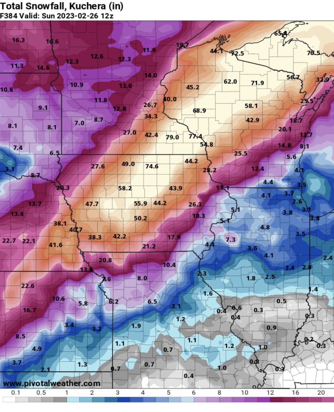
GFS continues to give S WI over 12" on kuchera ratios and over 7" in positive snow depth change. Can't see how this will be a warning criteria storm here. Looks like a slight SE trend on the Euro over the past few runs
-
Will this be the answer to N Illinois' prayers? Will it hit the DBQ-MSN-OSH corridor again? will it get sheared out and go far SE and weak? Stayed tuned here for the answers
-

Winter 2022/23 Medium/Long Range Discussion
madwx replied to Chicago Storm's topic in Lakes/Ohio Valley
under on all of them -
Who left Beavis in charge of today’s GFS?

-
February 8-9 Should There Be a Thread For This Storm
madwx replied to Hoosier's topic in Lakes/Ohio Valley
-
February 8-9 Should There Be a Thread For This Storm
madwx replied to Hoosier's topic in Lakes/Ohio Valley
Madison got 4.8” of snow and the temp never went below 33 yesterday -
February 8-9 Should There Be a Thread For This Storm
madwx replied to Hoosier's topic in Lakes/Ohio Valley
still at 36 well after the storm has ended here. Arctic air has been completely absent behind ever storm system this winter besides the pre Christmas storm -
February 8-9 Should There Be a Thread For This Storm
madwx replied to Hoosier's topic in Lakes/Ohio Valley
4.8” with snow slowing down. Not looking forward to the upcoming shoveling -
February 8-9 Should There Be a Thread For This Storm
madwx replied to Hoosier's topic in Lakes/Ohio Valley
2.7" of pure concrete so far. been a little over an inch an hour since it transitioned to snow -
February 8-9 Should There Be a Thread For This Storm
madwx replied to Hoosier's topic in Lakes/Ohio Valley
Yeah it’s been coming down big league here since about 830. At least a couple inches on the ground and the wind has picked up tremendously. Had sleet for a couple hours before that and roads were ice covered -
Winter 2022/23 Medium/Long Range Discussion
madwx replied to Chicago Storm's topic in Lakes/Ohio Valley
Sucks to be them -
February 8-9 Should There Be a Thread For This Storm
madwx replied to Hoosier's topic in Lakes/Ohio Valley
Time 2 jackpot -
Winter 2022/23 Medium/Long Range Discussion
madwx replied to Chicago Storm's topic in Lakes/Ohio Valley
at least the sun will be out -
up to the upper 40s. Looking like we'll do this again early next week
-
February 8-9 Should There Be a Thread For This Storm
madwx replied to Hoosier's topic in Lakes/Ohio Valley
looks like MSN is reeling this one in. Partying like it's 2007-2009 again -
February 8-9 Should There Be a Thread For This Storm
madwx replied to Hoosier's topic in Lakes/Ohio Valley
Hoping to thread my morning commute in before the changeover so I can just watch the rippage outside my office window -
February 8-9 Should There Be a Thread For This Storm
madwx replied to Hoosier's topic in Lakes/Ohio Valley
0Z models say wagons SE so far -
snowpack definitely got nuked overnight. Should be down to piles before any snow starts falling on Thursday morning.
-
February 8-9 Should There Be a Thread For This Storm
madwx replied to Hoosier's topic in Lakes/Ohio Valley
This is a perfect storm to use positive snow depth change model outputs. Kuchera and especially 10:1 are going to to far overestimate actually accumulation along the rain snow line -
Winter 2022/23 Medium/Long Range Discussion
madwx replied to Chicago Storm's topic in Lakes/Ohio Valley
Yeah, this does concern me, but it's not a death knell. Feb 2001 had a SSW and it was at the end of a multi year La Nina and April was above average. -
Winter 2022/23 Medium/Long Range Discussion
madwx replied to Chicago Storm's topic in Lakes/Ohio Valley
5-6-7 is a good way to stay above average through the 18th or so