jojo762
-
Posts
4,228 -
Joined
-
Last visited
Content Type
Profiles
Blogs
Forums
American Weather
Media Demo
Store
Gallery
Everything posted by jojo762
-
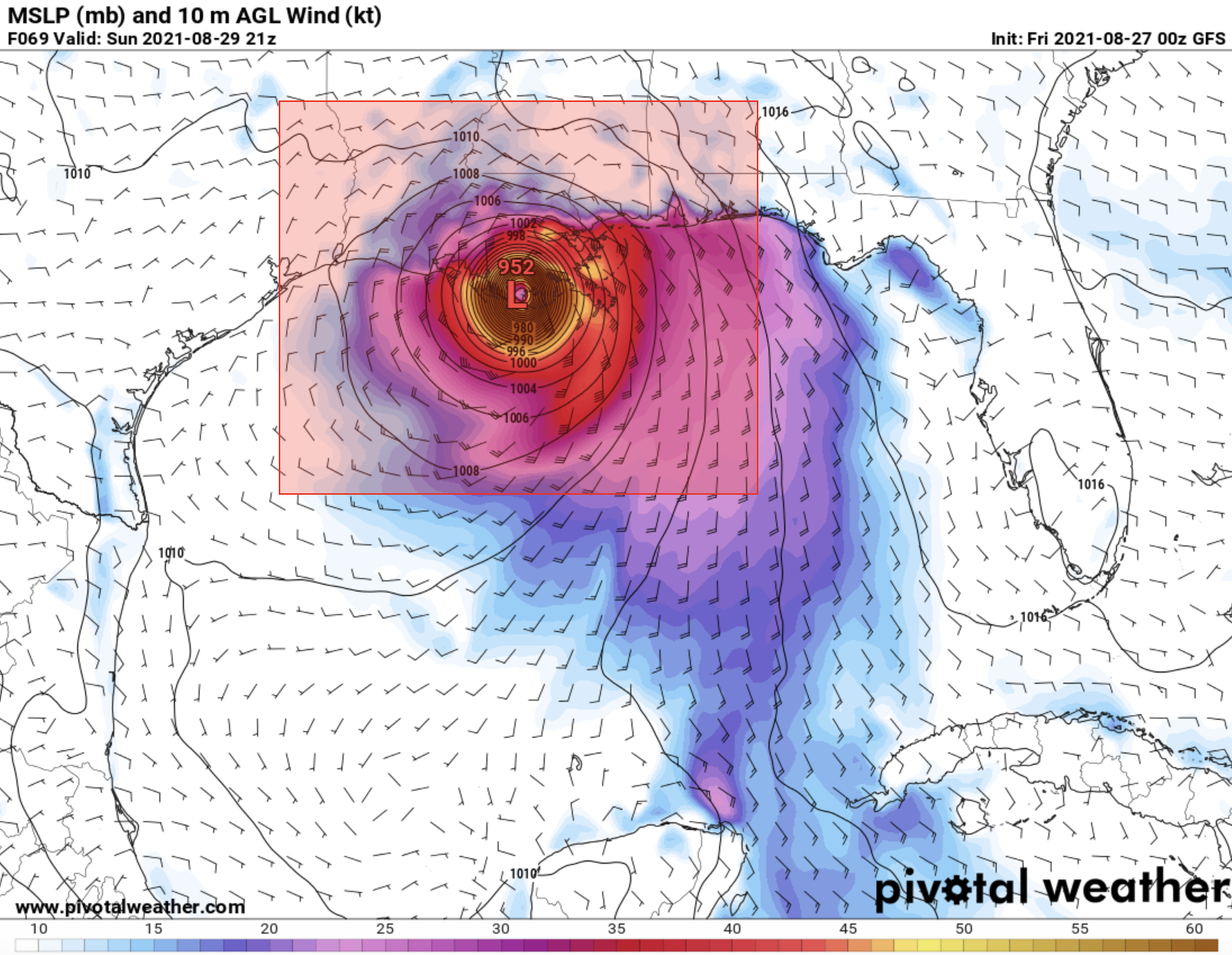
Ida high-end cat 1 and on the precipice of Cat 2 strength per latest recon..
-
Really cranking now... convection rapidly wrapping upshear.
-
I'm guessing, basing off the recon altitude data, that they got pretty shook by the eye wall. Not too surprising given the intense nature of the convection around the eye.
-
Extrapolated. But it seems unlikely that the dropsonde would be too far off from that.
-
If you believe what the GFS is selling, there sure is not going to be much -- if any -- shear to speak of on Sunday to impede Ida from intensifying right up to landfall... Not great.

-
Data is not data when it comes to the NAM and tropical systems. It's a fact everyone has to learn when they want to track AO TCs.
-
Was just about to post about this... But the overall structure of the system has ramped up the last few hours. In addition to what you stated, Ida is starting to take on the classic "shrimp" look, albeit still kind of dry and disorganized look. The outflow is really starting to crank too in all/most quadrants. This isn't exactly a bold take, but seems like Ida has a real shot at cat 1 status prior to Cuba if this steady structural re-organizing continues throughout the night and into tomorrow.
-
Basing on latest ASCAT pass depicting 35kt winds, as well as recent visible satellite imagery depicting what appears to be a developing LLC i'm guessing that NHC will start issuing advisories on this thing fairly soon. They *could* name it if they want, since vis sat does seem to indicate at least some weak westerlies at the surface (indicating the presence of an LLC), but ASCAT says that we do not yet have a true LLC -- so they'll probably stick with the "PTC" label if/when they do issue the initial advisory.
-

Central/Western Medium-Long Range Discussion
jojo762 replied to andyhb's topic in Central/Western States
ICT was pretty gung-ho about Saturday in their afternoon AFD. -
Central/Western Medium-Long Range Discussion
jojo762 replied to andyhb's topic in Central/Western States
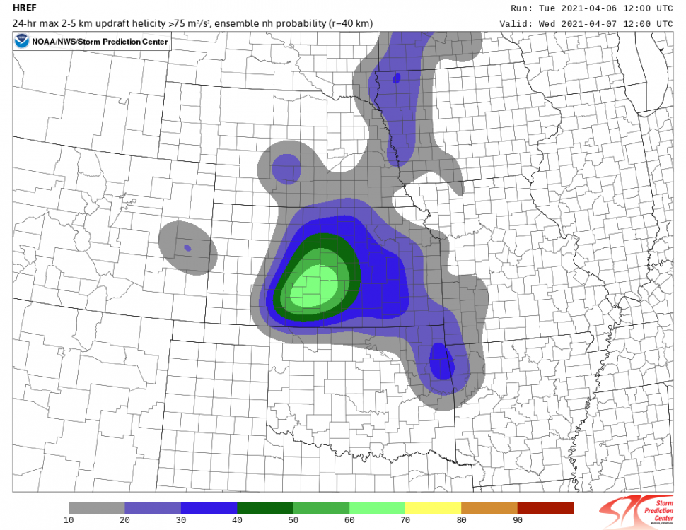
Models are beginning to come into maybe some agreement for an apparent severe weather threat near the I-35 corridor in KS/OK on Saturday. It's a pretty subtle S/W that, for the most part, has not been particularly well modeled to this point (eg. the Euro did not even show it until last night's 00z run). Still some issues to work out. But 18z GFS and 12z Euro are in pretty dang good agreement for a 100+ hour forecast. Attached 500mb, 850mb, and SFC td map from 12z Euro. -
Fairly notable differences for Monday between the core models we typically base our forecasts off, GFS and NAM are further east with the cold front on Monday while the ECMWF develops a triple point with a SFC low across central OK with a weak dryline extending southward into northern Texas. on Monday afternoon/evening. ECMWF solution would actually be quite interesting from a chasing perspective, while the NAM and GFS would probably yield mostly nocturnal SVR-caliber storms along the cold front. Interested to see if the 12z Euro "sticks to its guns."
-
Going to go ahead and give the upslope flow a shot in NW KS/NE CO. Very much a boom or bust day... We'll see how it goes, but i'm cautiously optimistic for now. Strong steam-wise vorticity combined with strong venting flow and low mid-level RH should at a minimum produce beautiful LP structures... Tornado threat is a bit more ambiguous, as is the case with most upslope flow setups. But easterly SFC flow combined with sufficient 3CAPE and do some spectacular things. Biggest question appears to be moisture as guidance provides a variety of outcomes. If we verify on the higher-end of progs it could be a big'ish day, if we verify on the low end it could be slightly boring from a tornado perspective.
-
Great write up. When that meso started expanding and got super convective looking (with all the inflow bands and readily apparent SVC) it was pretty obvious something big/fun was about to happen. Never could've imagined beforehand that the day would go that well. Great pics!!!
-
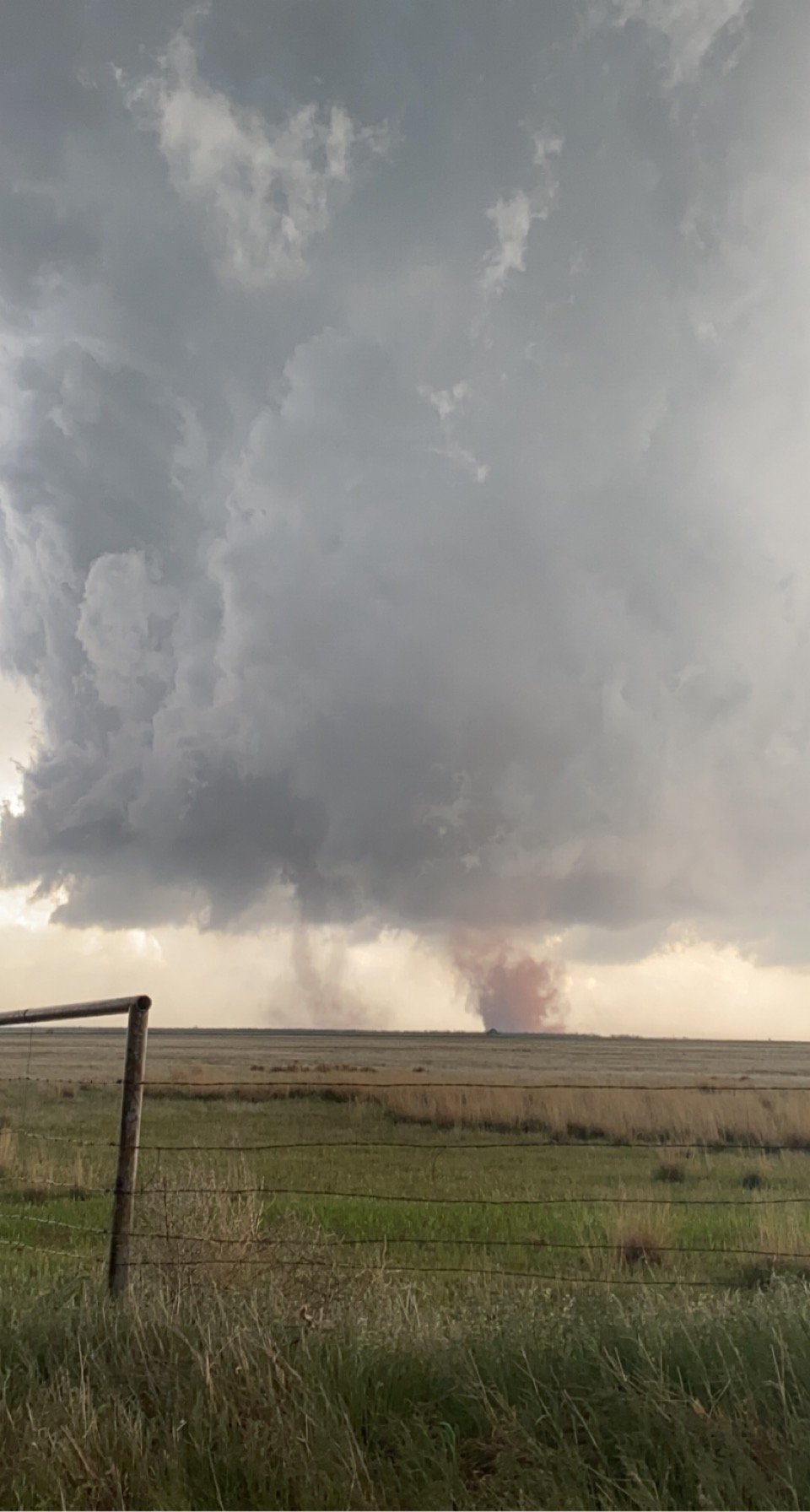
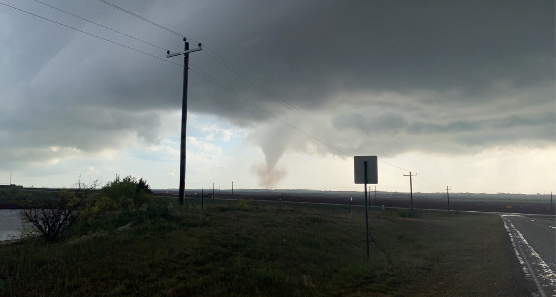
Yesterday was easily one of my favorite chases i've ever been on -- up there with , and probably exceeding, McCook/Farnam 2019. Initially was wanting to sit in Vernon to hedge between potential supercells farther down the dryline vs the triple point, proceeded to Crowell, TX and decided the triple point was the play I was going to be making as the northern storm that initiated near CDS quickly acquired a low-level meso (despite that the updrafts to the south looked very stout and impressive). Storm generated a nice wall cloud before cycling/going outflow dominant for a bit (which was certainly concerning), but reorganized over the next forty minutes and put on a show shortly thereafter. Altogether between 5:30 and 6:30pm saw at least 8 tornadoes, including twins. Wish I would've been more aggressive with my driving (i.e stayed going south on TX highway six instead of cutting east), as some people that were closer got some mind-numbingly beautiful shots.

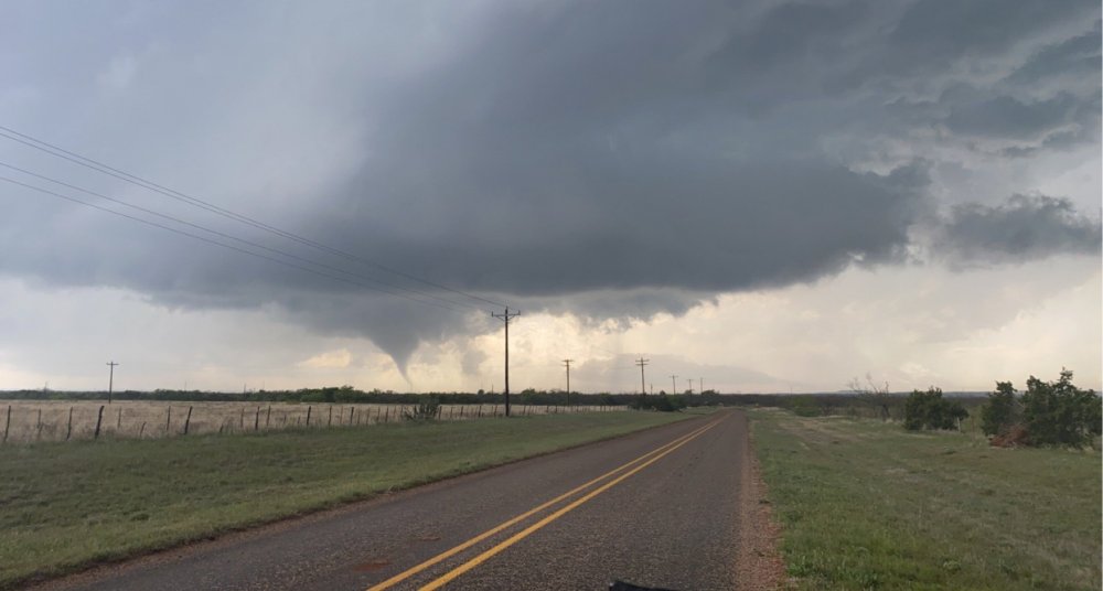
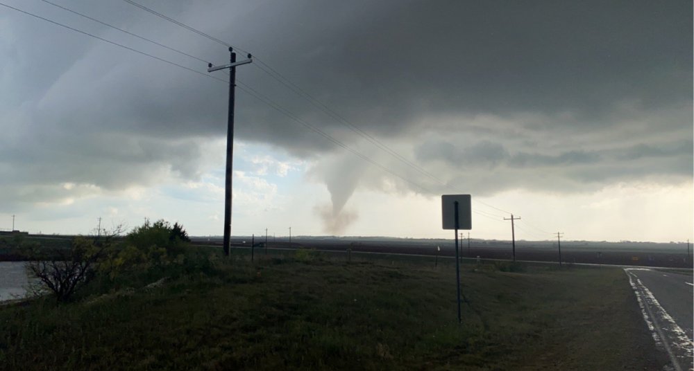
-
Combo of SDS and FOMO today was real with me today. Left KC prior to 8am for somewhere between Childress to Wichita Falls. Like my chances of a photogenic supercell. Ingredients *could* materialize for a decent tornado threat from 23-01z.
-
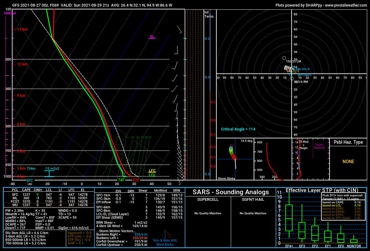
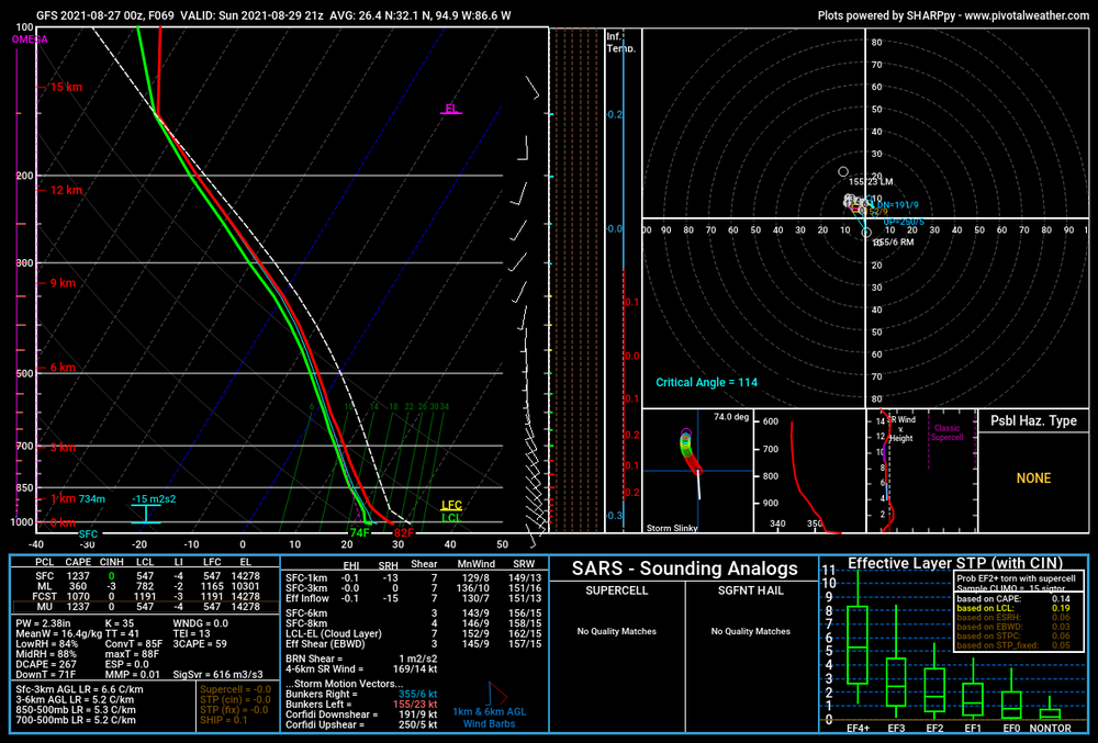
00z ECMWF last night continued to show a highly volatile setup from NE KS into western OK and down into TX. From a synoptic-scale it really does not get much more obvious than this. Euro depicts the 70-80kt mid-level jet core impinging across the dryline by 00z with a 40-50kt southerly LLJ east of the dryline. The warm-sector on the euro is quite expansive, characterized mostly by mid-60s dewpoints and strong instability. Parts of the dryline are plagued by strong CINh, and this is well seen in the euro QPF fields hinting at limited coverage along the dryline in OK and TX and coldfront in KS. This would not qualify as a true write-up about the 00z Euro if it did not feature at least one cherry-picked, "eye candy" sounding. (roughly halfway between Woodward and Elk City)
-
Central/Western Medium-Long Range Discussion
jojo762 replied to andyhb's topic in Central/Western States
GFS hints at this very idea (and has actually for several runs, really), with early May potentially being a powder keg over the Plains. Euro and EPS are on a bit of an island right now wrt to the trough evolution on Tuesday. That's not to say that it couldn't end up being right -- but generally the days of the euro absolutely owning mid-range verification seem to anecdotally be coming to an end. -
Looks like the long awaited return of a severe-favorable pattern is coming soon. Next Tuesday is looking potentially big-time from a severe weather prospective across the Plains. Big-league negative tilt trough with a strong LLJ. Main question at this point seems to be moisture.
-
Central/Western Medium-Long Range Discussion
jojo762 replied to andyhb's topic in Central/Western States
General idea in mid/long-range guidance is that there could be a solid trough in the southern Plains next week... Not much agreement on timing or degree of moisture ATTM, but at least its something to watch? -
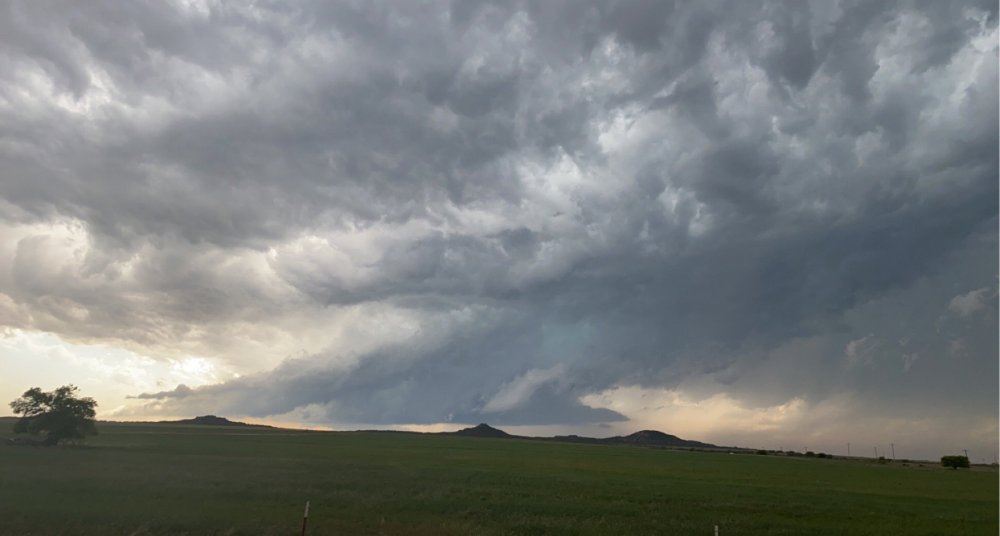
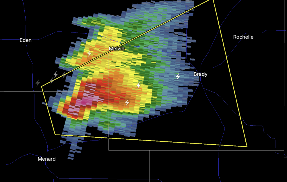
Brady, TX could take a beating from this one in a half-hour or so.
-
Theoretical chase target today is Eden, TX... basing on current obs I may adjust a bit further east toward Brady, but either way today looks primed for several strong supercells along the stalled frontal boundary in Central TX. 12z RAOBs from MAF and EPZ depicted 850-500mb lapse rates of 7.8-8.0 C/km, this combined with a strongly mixed PBL by late afternoon will create moderate CAPE profiles along the boundary, this thermo profile juxtaposed with elongated mid-level hodographs will result in supercells capable of very large hail shortly after initiation. The tornado threat is very minimal today owing to very weak 0-3km shear. Given the strong mid-level winds and relatively dry low to mid-levels this type of setup could yield a fairly beautiful high-based supercell or two...
-
Central/Western Medium-Long Range Discussion
jojo762 replied to andyhb's topic in Central/Western States
I'd take it... 2013 was VERY boring until the last two weeks in May -- which saw NINE Moderate risk days across the Plains, with some very notable tornadoes thrown in there: Our last official EF5 tornado, in Moore, and the El Reno 302mph, 2.6 mile wide tornado to name a couple. -
Central/Western Medium-Long Range Discussion
jojo762 replied to andyhb's topic in Central/Western States
Extended range guidance looks *very* rough for OK/KS... Some potential for a setup on Friday in Texas as @Chinook alluded to, but still inconsistency in modeling. Looking like we will have a strong STJ influence across the northern Gulf coast for quite sometime, which clearly is not favorable for moisture return into the plains. Ultimately there will probably be some SLGT-risk caliber setups in TX the next 10-14 days, but probably nothing superbly obvious. FWIW (which isn't much), latest long-range fantasy land guidance suggest it could be well into May until we see another favorable SW-flow setup in the Plains -- yikes. -
I'm not going to pull the trigger on saying there will for sure be N TX dryline storms today... But SFC temps sure seem to be running at-forecast or even a smidge above 12z HREF mean temps for 15z. The cloud cover doesn't seem to be having much of an impact -- and it looks like the LLVL clouds could clear out a bit more.
-
While there are very clearly issues with today's setup (eg. lingering CINH and seasonally marginal moisture) 12z CAMs are really hammering the area INVOF the triple point in southwest/central KS this evening for potential isolated supercell development. IF this does actually happen, it could get pretty interesting if the storm were to become surface-based and lower its base a bit as SRH will be quite conducive for low-level mesocyclones.