

jojo762
-
Posts
4,228 -
Joined
-
Last visited
Content Type
Profiles
Blogs
Forums
American Weather
Media Demo
Store
Gallery
Everything posted by jojo762
-
NOAA plane also found a 147kt FL wind (~170mph).
-
138kt FL wind, 129kt SFMR. Not quite enough yet to push us into Cat 5 territory
-
Katrina was also *BAD* for reasons well outside of just the “hurricane being intense.” Katrina will always been in a league of its own. I suppose it’s conceivable that some day it gets beat, as all records are meant to be broken, but don’t think this is the angle of approach to do it for NOLA. LIKEWISE, some of these smaller towns east of the eye could be wiped off the map… sadly.
-
AF305 going in for a NE-quad pass… Cat 5 data incoming soon? I think so.
-
Landfall somewhere in Barataria Bay is looking like a pretty safe bet imo at this point.
-
Yep.
-
Now this is the skew-t of a rapidly intensifying hurricane... wow.
-
Eyewall is going absolutely bonkers on GLM. Tons of lightning detected by GOES.
-
Dropsonde measured 950mb with a 7kt wind. Not quite what we saw from the extrapolated pressure.
-
It is absolutely wild being able to see convective blow ups on IR and a corresponding increase in reflectivity on KLIX. Hadn't really noticed that myself before with previous systems.
-
153mph FL winds + ~127mph SFMR... Yeah i'd go ahead and say this'll be upgraded...
-
wow. 133kt FL, 110kt SFMR... 943.6mb extrap. EDIT: I'll also add that there were higher SFMR readings, but they were flagged.
-
Didn't get data all the way through the eyewall/into the eye. But 116kt FL wind..
-
Recon is really about to take it on the chin when they enter the eyewall. Brand new VHT just wrapped around that side, evident both on IR and KLIX radar.
-
115kt seems reasonable. I'll say we get cat 4 winds either this pass, or the next NE quad pass.. Been going off for awhile.
-
AF302 leaving San Antonio now... So pretty much constant recon all night.
-
Cat 4 on this NE-SW pass or nah?
-
Trochoidal wobbles are going bananas right now with Ida on IR imagery.. Not something we see frequently.
-
The breadth of the hurricane-force FL winds in the southeast quadrant is nuts.
-
955mb center drop. Impressive strengthening since last recon.
-
94kt max SFMR in the SE eyewall, with 110kt max FL wind... I'd feel fine upgrading to 100kt/115mph now. But may as well wait until we see what the NE/E quad bring.
-
954mb extrap... 110kt FL winds in the SE quad...
-
Per latest recon data hurricane-force wind radii has expanded greatly in the northwest quadrant... Not great.
-
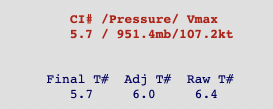
Unapologetically, I present the ADT estimates again, but probably the last one i'll post. ~125mph cat 3 Final T#, Raw T# well into cat 4 strength.
-
Actually they likely organized an impromptu emergency recon flight (when one was really, already, supposed to be happening but wasn't due to mechanical issues)...


