

jojo762
-
Posts
4,228 -
Joined
-
Last visited
Content Type
Profiles
Blogs
Forums
American Weather
Media Demo
Store
Gallery
Everything posted by jojo762
-
DMAX will do that. Fudging insane progression last 3 hours on IR imagery. Recon will almost certainly find cat 3 winds somewhere in the eyewall... Possibly cat 4, which would be some remarkably *rapid* intensification.
-
Ida is gonna look pretty mean when that DMC band currently wrapping around the south side gets to the east-side.
-
What recon finds from a Vmax perspective is highly dependent on what type of passes they do (so for example the initial pass could be unimpressive from a wind perspective if the go NW/SE) ... But after they've done the NE quad i'm assuming we'll have a 954mb, 105kt/120mph cat 3. I'll also add that I think we make landfall in the upper 930s (as shown by hi-res guidance), and max winds ~130-140mph.
-
KLIX measuring 30+dbz in the northern/northwestern eyewall at ~35,400ft-38,200ft.
-
Looks like we should get a center fix in about 1.5 hours.. ~0430z.
-
Surprising... But with a recon mission en route that's actually reasonable... Can make any upgrades as necessary when the plane arrives.
-
Believe it or not, GOES GLM does not detect any lightning currently in the eyewall of Ida.
-
Clearing out an eye is an extremely dynamic process, that involves a lot of wobbling around, etc... that gives off the appearance of something like "a new tiny eye coming in and replacing the old tiny eye." Once you've seen enough of them, you figure out that they are bizarre, seemingly inexplicable cycles/processes.
-
Honestly think NHC will go ahead and nudge this up to 100kt with the 03z advisory... maybe even higher if we pop a warming eye with all this intense convection ongoing.
-
*AF recon has issues resulting in no recon until very early in the morning* Ida: "hold my beer"
-
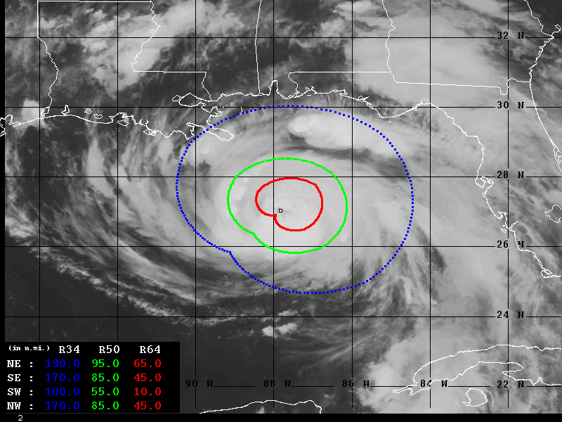
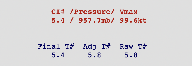
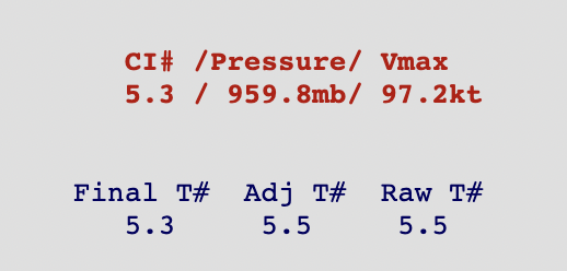
Hurricane-force wind radii is quite large. If landfall still occurs near OFCL theres a chance areas as far as the LA/MS coast could see hurricane-force winds -- likely for several hours. Meanwhile raw ADT estimates are approaching category 4 intensity... but the final ADT# is sitting at ~115mph.
-
967mb drop with 10kt sfc wind.
-
Most importantly the max-winds are much closer to the eye than they were in the original pass a couple hours ago. Sure looks like all systems are go...
-
91kt/105mph FL and 85kt/98mph SFMR found by recon in the NE quad, as well as extrap pressure of 965.1mb.
-
For posterity.
-
Dvorak T# estimates we are on the verge of category-three intensity.
-
The circulation has tightened greatly on IR the last 15 minutes with miniature hot-towers going up on the north and east part of the circulation.
-
Basing off the NOAA HH data sure looks like Ida is closer to a 90mph storm right now than a 105mph storm.
-
Roughly a similar intensification rate to the previous six hours as well...
-
Interested to see what happens with that strong area of subsidence that has developed on the west-side of the CDO. Not quite sure what to make of it, and if it actually means anything to the circulation's likely RI tonight.
-
To clarify, I do actually agree that Ida looks the best it has all afternoon. But that does not mean that it's core has not sputtered most of the afternoon and morning -- while still gradually intensifying. Likewise we're approaching the well-advertised go-time/Dmax, so this whole "it's sputtering" argument is about to get blown to smithereens.
-
The storm is in a pristine environment for intensification, and its core has sputtered most of the morning and afternoon on satellite -- struggling to become inertially stable, which would allow more energy to be expended on intensification instead of structural matters.... Little doubt it will eventually undergo RI, but its current state at this moment in time does not seem like it would readily allow for it. EDIT: There's been posts all morning and afternoon doing a PxP of "wow the IR presentation looks the best yet!!"
-
I understand that they missed the true-center to the south by a little bit.. But this is not exactly the most impressive eye dropsonde -- speaks to the structural/organization troubles Ida has had today wrt intensifying at a greater clip. For some reason the core has really struggled to become better organized/tight today, not sure why really. Not something we are going to be able to diagnose easily without the HH radar readily available.
-
Eight additional Hurricane-force wind barbs on the TT recon map between the max and the beginning of the eye. With the strongest systems, from my experience, there’s usually the strongest winds of the hurricane and then the beginning of the eye with no space in between really.
-
That kind of wind profile they found, with the main wind-max displaced from “where it should be” with what we traditionally think of as a storm “about to undergo” RI, just doesn’t make it seem like it’s going to be able to intensify rapidly anytime soon. Perhaps it was their weird flight heading change before entering the eye, but that’s just my two-cents.


