
MNstorms
-
Posts
446 -
Joined
-
Last visited
Content Type
Profiles
Blogs
Forums
American Weather
Media Demo
Store
Gallery
Everything posted by MNstorms
-

2023 Short/Medium Range Severe Weather Discussion
MNstorms replied to Chicago Storm's topic in Lakes/Ohio Valley
Tomorrow looks more interesting than Friday for me. -
Warned for 80mph winds. 75mph observed.
-
Tonight looks decent, at least the best chance for myself this season. More CAPE then one could ever ask for. Probably a step under a derecho. I thought an enhanced risk would be issued on the last update.
-
2023 Short/Medium Range Severe Weather Discussion
MNstorms replied to Chicago Storm's topic in Lakes/Ohio Valley
Looks like the TORD radar may have failed. Hasn't updated for 12 minutes. -
2023 Short/Medium Range Severe Weather Discussion
MNstorms replied to Chicago Storm's topic in Lakes/Ohio Valley
This is probably the worst area a tornado could ever be. -
2023 Short/Medium Range Severe Weather Discussion
MNstorms replied to Chicago Storm's topic in Lakes/Ohio Valley
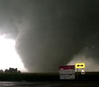
Interesting storm shape. -
Wouldn't be surprised to see a slight risk added to Minnesota and Dakotas for tomorrow. Might be the best chance of the year to actually get a storm for me. Still sitting at 0s.
-
Getting real bored here. Barely have heard thunder this year. This is the latest in my life I've gone without even a slight risk. Nothing in the forecast. I've had 0 watches or warnings. MPX has issued a record low 6 Tornado Warnings. Dull.
-
Exactly like I said. This was 30-40 minutes later.
-
Correct. There was tornado widely report first south of Gering.
-
People went full Jonesboro again. Hills blocked their view and called a lowering a tornado. I've been watching a stream that was close up and they had nothing. Edit. Proof before I get told off. A chaser with a similar view to Freddy's deleted their tweet and called this a tornado. A couple minutes later pass the hills.
-
Record breaking smoke and it may get worse overnight.
-
Looked straight up cloudy for a bit. Made it feel not as hot out. Sun wasn't even peaking out.
-
0.1'' - 0.5'' rain was forecasted last night. Everywhere got at least 1'' with widespread 3-5''. Lots of flooding.
-
Looks like Minnesota and Iowa are in play for Friday. Gotta wait another couple of runs to see. Wouldn't be surprise to see a Day4 tonight.
-
Severe Weather 4-19-23 through 4-21-23
MNstorms replied to cheese007's topic in Central/Western States
It's becoming predictable where the next rotation will be. -
Severe Weather 4-19-23 through 4-21-23
MNstorms replied to cheese007's topic in Central/Western States
Yikes -
Severe Weather 4-19-23 through 4-21-23
MNstorms replied to cheese007's topic in Central/Western States
About to be another to the south -
Severe Weather 4-19-23 through 4-21-23
MNstorms replied to cheese007's topic in Central/Western States
Debris ball. -
Severe Weather 4-19-23 through 4-21-23
MNstorms replied to cheese007's topic in Central/Western States
Reed Timmer has a tornado with this -
This is the first model run that all 3 short model have even been close to agreement. Reminds me a bit of May 2, 2013 snow.
-
Time to get excited!
-
90F to snow in 2 days.
-
Got up to 89F today. Several places in Minnesota tied the record for earliest 90F in state history. Haven't seen a 91F. Edit, actually looks like 90F here too.
-
Minneapolis will likely break it's record warm low today. Still 71F at 1am. Record is 60F. Record today is 83F. I wonder if we could get the earliest 90F on record by 3 days.


