MNstorms
-
Posts
446 -
Joined
-
Last visited
Content Type
Profiles
Blogs
Forums
American Weather
Media Demo
Store
Gallery
Everything posted by MNstorms
-
Interesting that they are issuing tornado warnings well ahead of the line.
-
Well I'm centered in this. SUMMARY...The threat of severe thunderstorms including tornadoes appears to be increasing across southern Minnesota and northern Iowa. DISCUSSION...Latest surface analysis continues to show a surface low associated with a well-defined MCV over southeast SD. A warm front extends eastward from the low along the MN/IA border. Relatively strong heating has been occurring along and north of the warm front over southern MN, where backed low-level winds and dewpoints in the upper 60s to lower 70s are resulting in a very favorable environment for supercell development. Recent CAM and WoFS solutions also indicate this potential. A compact low-level jet is expected to strengthen in the next few hours in this area as well, enhancing low-level shear and suggesting a heightened risk for a few tornadoes. Large hail and damaging winds would also be possible with storms along/north of the warm front. Farther west, radar suggests a developing bowing complex over Murray/Cottonwood/Nobles/Jackson counties MN. This activity will likely accelerate eastward along the warm front during the next 2-3 hours, posing an enhanced risk of damaging wind gusts and transient QLCS spinups.
-
Multiple tornado warnings now.
-
Tornado watch expanded.
-
SUMMARY...A severe hail, wind, and tornado risk persist mainly from southeast South Dakota into southwest Minnesota. Hail may eventually occur north of the tornado watch. DISCUSSION...An MCV continues to move rapidly north, now crossing the MO River out of northeast NE, with arcing line of storms extending southeastward along the valley. Meanwhile, other storms currently extend from west of FSD north and eastward into southwest MN near the warm front. Surface observations show a cool boundary layer along the warm front, which has recently become reinforced by outflows. In addition, dewpoints continue to fall in the well-mixed air across IA. The result is a relatively narrow zone of tornado potential over the next few hours, from southeast SD eastward along the front into southern MN. Any supercells in this zone may produce a brief tornado, but meridional flow aloft near the MCV may push cells quickly north of the boundary where they will become elevated.
-
This is after 25 minutes. Already a solid supercell.
-
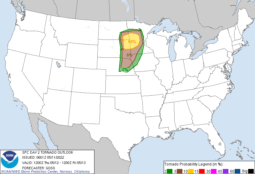
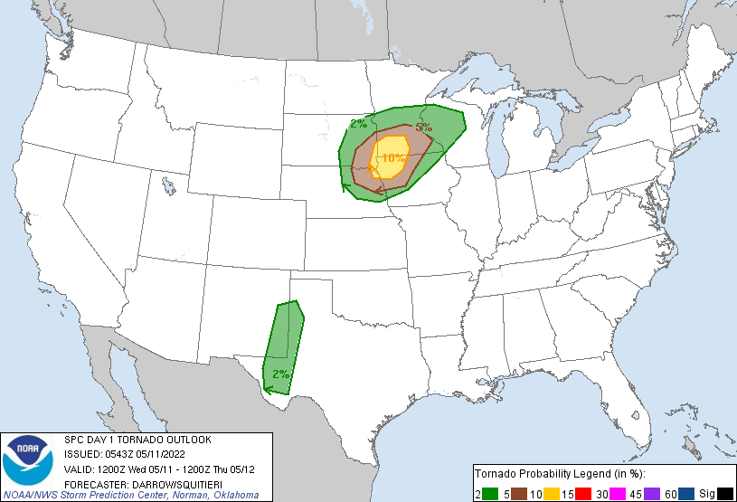
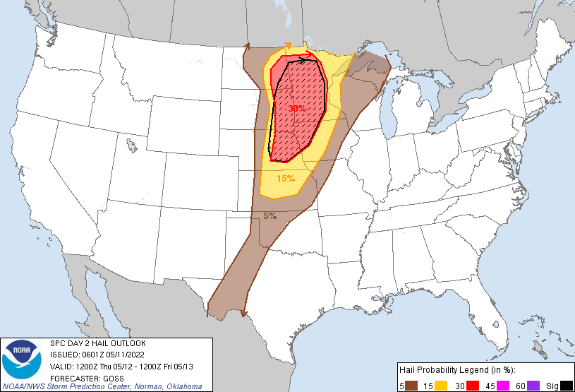
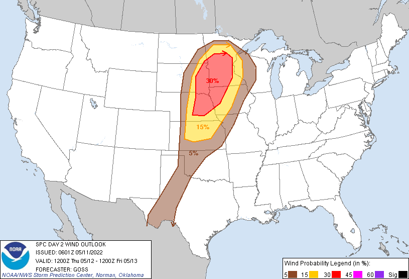
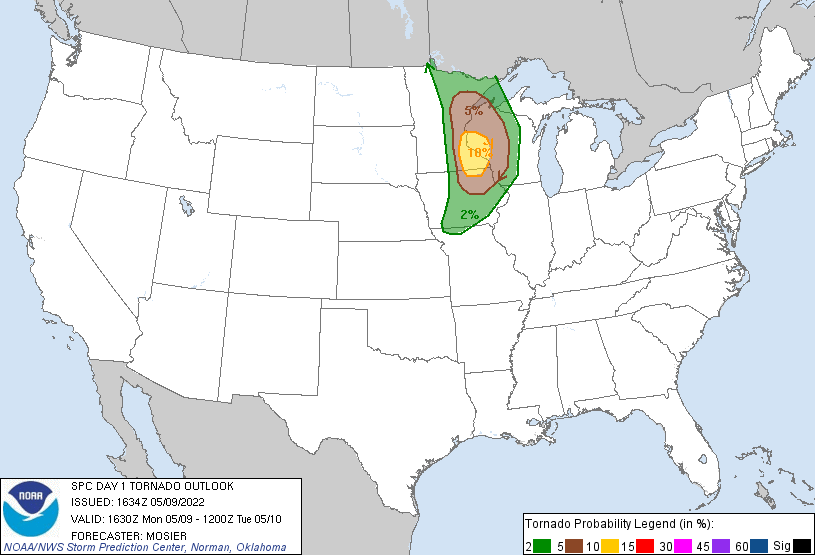
I don't remember the last time I saw back to back 10% tornado risks in Minnesota. Day 1 ...SUMMARY... Severe thunderstorms are expected this afternoon/evening over the north-central states. Very large hail, wind, and a threat for tornadoes is expected. Additionally, widely scattered severe thunderstorms are anticipated across the southern High Plains. Wind/hail are the primary threats. ...North-Central States... Weak mid-level short-wave trough that translated across northern Mexico into the southern High Plains Tuesday afternoon has contributed to a substantial MCS over the eastern TX Panhandle into western OK. This convection is expected to propagate slowly east and gradually weaken by sunrise. However, latest diagnostic data suggests an MCV has evolved over the northeastern TX Panhandle along the northern fringe of the MCS. HREF members appear to have sampled this feature well, and subsequent movement should track north-northeast across KS into southeast NE by 18z, then into southern MN by 12/00z. As the mid-level feature lifts northeast, LLJ should respond and strengthen across western IA into western MN. This will encourage the warm front draped across IA/southeast NE to retreat into southern MN prior to the aforementioned short wave. Surface dew points are quite high across the warm sector south of this boundary and moderate/high buoyancy is expected to develop by mid day. Maximum surface heating/steepest surface-3km lapse rates are forecast across NE into extreme western IA. As a result, there is increasing concern that supercells will develop ahead of the short wave/MCV by 19-20z over eastern NE, then spread northeast along the warm front. Ample shear/buoyancy will be present for very large hail with this activity, along with a tornado threat. Have increased severe probabilities for this corridor to account for more pronounced supercell threat ahead of this MCV. Day2 ...SUMMARY... Well-organized severe storms are expected to evolve from the eastern Dakotas and Minnesota southward into the central Plains Thursday. Very large hail and damaging winds are expected, along with potential for a couple of tornadoes. ...Synopsis... While an upper low retrogrades westward out of the western Atlantic into the Southeast, a vigorous, increasingly negatively tilted trough will advance rapidly northeastward from the Rockies into/across the northern and central Plains Thursday. As this occurs, rapid surface cyclogenesis will occur across the Dakotas during the afternoon and evening, with the low becoming occluded overnight as it retrogrades northwestward into northwestern North Dakota through the end of the period. Meanwhile, a warm front will shift northward across the upper Mississippi Valley, while a cold front advances eastward across the northern and central Plains through the period. ...Eastern Dakotas east to the Upper Mississippi Valley and south across the Mid Missouri Valley... Lingering/elevated convection -- and possible/low-end severe potential -- may be spreading across Lake Superior/western Upper Michigan/northern Wisconsin at the start of the period. Meanwhile, diurnal heating of a moist airmass across the north-central U.S. will commence. While warm-sector capping will inhibit storm initiation well into the afternoon, increasing ascent ahead of the advancing upper system -- focused near the surface cold front -- will result in storm development within a zone from central/eastern South Dakota southward into northern Kansas. Given increasing flow aloft supporting favorable shear for organized storms, updrafts will likely acquire rotation rather quickly. Very large hail and locally damaging winds can be expected, with a couple of tornadoes also possible -- particularly near a northward-moving warm front expected to extend from an eastern South Dakota surface low, eastward across the central Minnesota vicinity during the afternoon and early evening. With time, upscale growth/linear organization of the convection is expected, possibly evolving into one or more small-scale bowing MCSs. Along with continued hail potential and some risk for a tornado or two embedded within the line, damaging wind risk would increase/expand into the evening hours, assuming this upscale evolution. Risk will likely continue into the overnight hours, though a general/gradual weakening of storms with time is expected.
-
Wednesday looks interesting. I wonder if we'll see in upgrade for Day2. RAP model is uhh, interesting... 8000+ CAPE anyone?
-
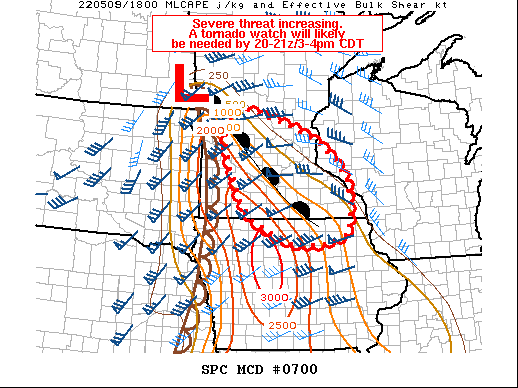
Tornado watch likely. I don't remember the last time I've seen a dry line this far north. Probability of Watch Issuance...95 percent SUMMARY...The airmass across southern MN into northern IA is rapidly destabilizing and severe potential is increasing. A tornado watch will likely be needed by 20-21z. DISCUSSION...The airmass across southern MN into far northern IA is rapidly recovering from morning convection and quickly destabilizating. Mid to upper 60s F surface dewpoints are now widespread across northern IA to near the MN state line as temperatures have warmed into the upper 60s to mid 70s. This is resulting in rapidly eroding MLCIN. Towering cumulus have been noted across southwest MN over the past hour or so as a north to south oriented surface boundary/dryline quickly progresses eastward. A warm front is extending southeast from a surface low near Fargo ND toward southeast MN. The warm front is forecast to lift northward into central MN/west-central WI over the next few hours. While large-scale ascent is forecast to remain rather weak, strong vertical shear, both effective and in the 0-1 km layer, steep lapse rates and strong instability will support organized supercells. Weaker forcing will likely limit the number of storms, but one or two intense cells are expected to develop over the next few hours. Current VWP data from the KMPX 88-D near the warm frontal zone already indicated enlarged, favorably curved hodographs with 0-1 km SRH greater than 450 m2/s2. Any cell that develops withing the northward retreating warm frontal zone will have enhanced tornado potential in addition to large hail and damaging gusts. MCD is farther west than I would have thought.
-
Big hailers tonight and tomorrow just going to miss me.
- 49 replies
-
- 1
-

-
- northern plains
- great plains
- (and 2 more)
-
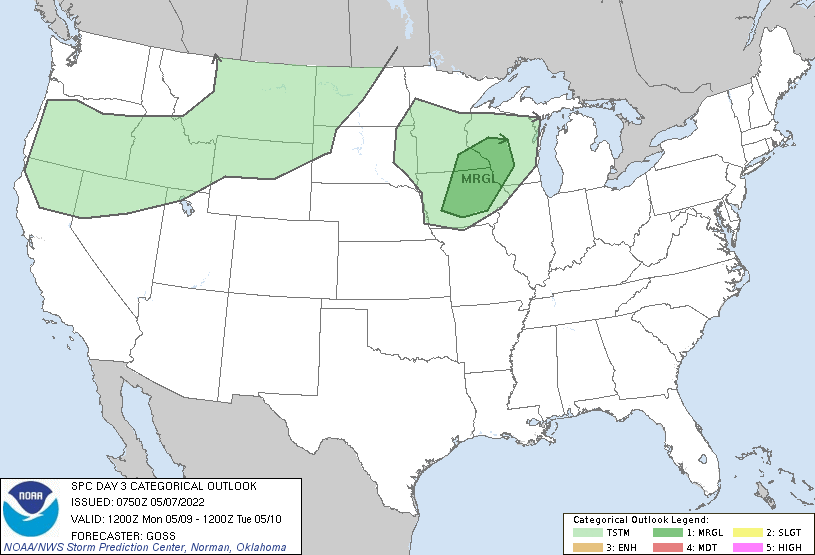
SPC still thinking Iowa to Wisconsin.
-
Both RAP and HRRR have insane ingredients but barely storms developing.

.thumb.png.6a01dadb7ee9cbded42d710b9d2407a4.png)
-
Well that's an interesting decrease in chances.
-
NAM isn't even close to agreement with other models for Monday.
-
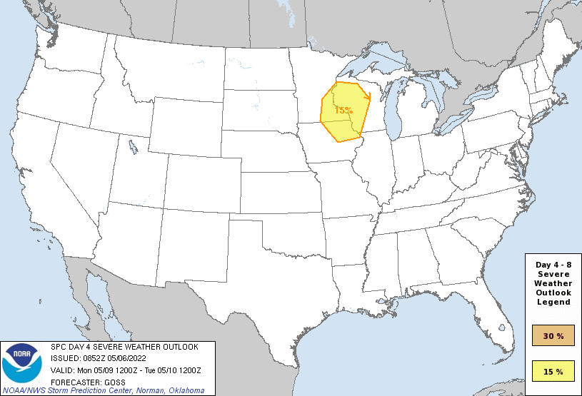
Looking more like a June weather pattern than a May one over the northern plains. There was an area highlight for Sunday but that was taken off today. Jet stream is really constant with trough ejections. Medium-range guidance is in good agreement that the overall upper pattern amplifies significantly on D4/Sunday and D5/Monday as western CONUS troughing deepens and upper ridging along the MS Valley builds. Position of the upper trough leads to deep southwesterly flow aloft across the Plains. At the same time, strong moisture advection will occur, with mid 60s dewpoints reaching eastern KS by D4/Sunday and into much of IA by D5/Monday. By D6/Tuesday, a large area of 70+ dewpoints may exist from the Arklatex north into IA. This low-level moisture, coupled with the EML fostered by the deep southwesterly flow aloft, is forecast to result in strong instability across at least some portion of the Plains and/or Upper/Mid MS Valley from D4/Sunday through at least D6/Tuesday. The somewhat stagnant upper pattern and lack of progressive surface features leads to dearth of forcing for ascent for D4/Sunday, leading to predictability issues. Some elevated thunderstorms are possible across the northern Plains, but uncertainty on location and overall severity merit precluding any outlook areas. Somewhat more discernible/predictable surface features are expected on D5/Monday, with a front moving into the upper MS Valley. Given the forecast buoyancy and shear, any storms that do develop will likely be severe. Some severe potential may persist across the Upper/Mid MS Valley on D6/Tuesday, but guidance varies crucially on the position of various surface features, limiting predictability. Additionally, guidance indicates that upper ridging will build west across more of the Plains on D6/Tuesday and D7/Wednesday, likely shifting the potential for storms back west towards the High Plains.
-

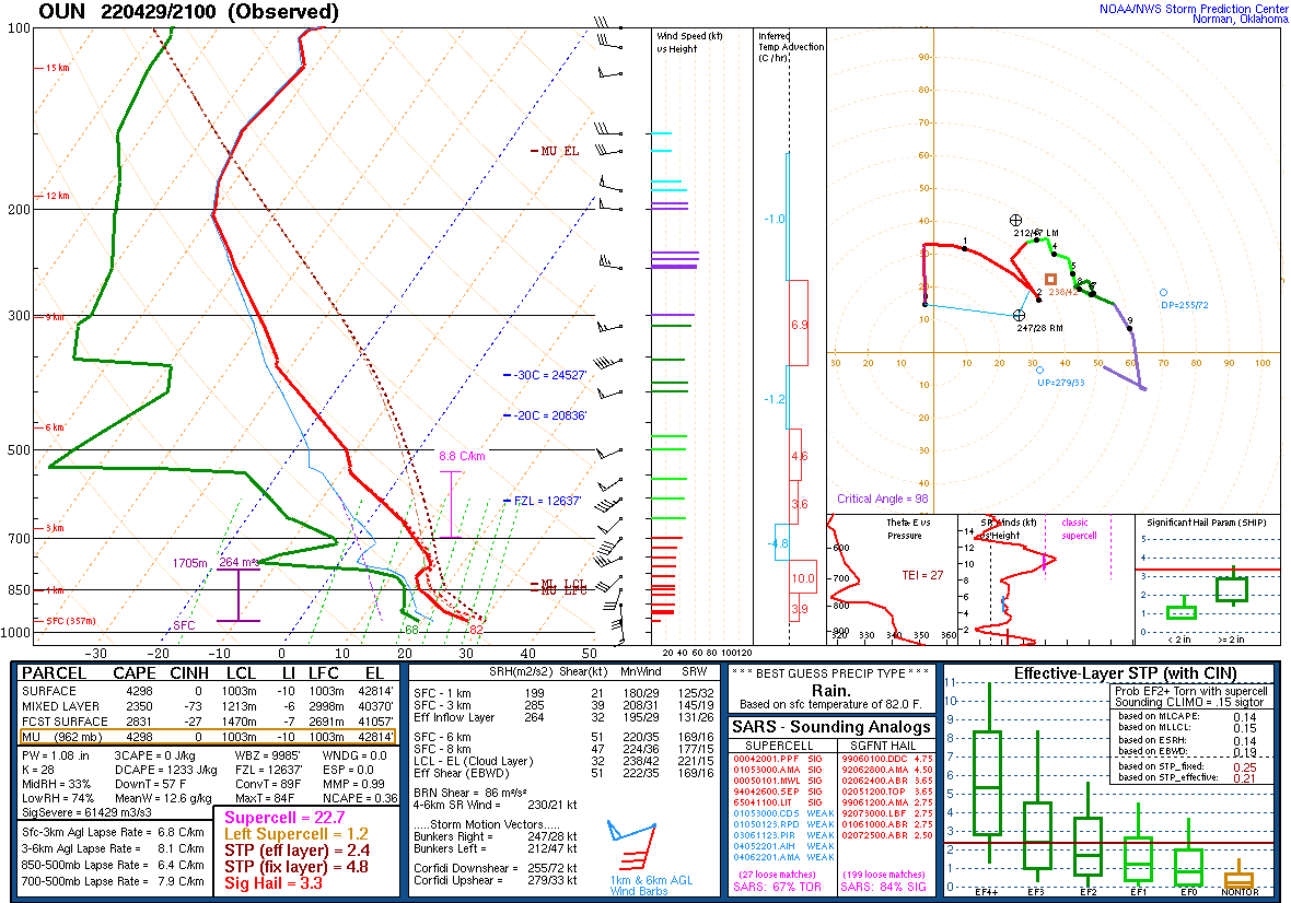
Central/Southern Plains Severe Weather Palooza (4/29 - 05/05)
MNstorms replied to Powerball's topic in Central/Western States
Wow -
Central/Southern Plains Severe Weather Palooza (4/29 - 05/05)
MNstorms replied to Powerball's topic in Central/Western States
Seminole circulation is over a mile wide. Jeez. -
Central/Southern Plains Severe Weather Palooza (4/29 - 05/05)
MNstorms replied to Powerball's topic in Central/Western States
Lots of supercells becoming organized. Not good. -
Central/Southern Plains Severe Weather Palooza (4/29 - 05/05)
MNstorms replied to Powerball's topic in Central/Western States
Here's KWTV stream -
Central/Southern Plains Severe Weather Palooza (4/29 - 05/05)
MNstorms replied to Powerball's topic in Central/Western States
Reed Timmer has a tornado near Dumont TX. Not even tornado warned yet. -
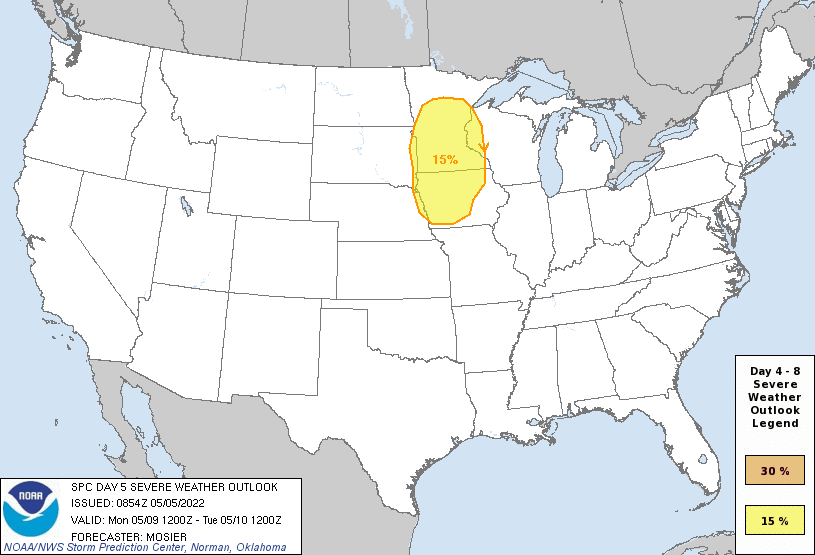
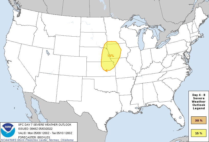
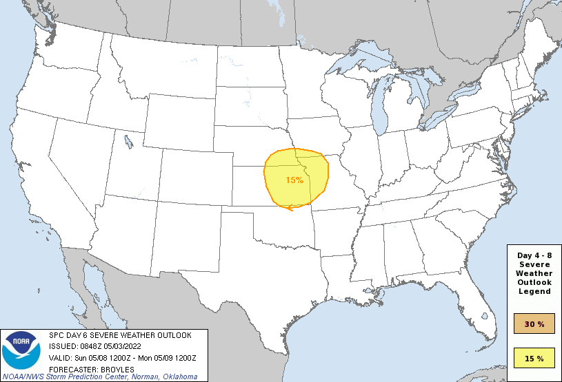
SPC now has these areas highlighted. On Saturday, the models are in better agreement, with a narrow corridor of moisture returning northward into the central Plains. Thunderstorms will be possible along the western edge and on the northern end of the stronger instability, in parts of central and eastern Nebraska Saturday evening. Forecast instability and deep-layer shear appear strong enough for a severe threat. But there is considerable spatial uncertainty and the magnitude of moisture return is questionable. For this reason, will hold off on a 15 percent contour at this time. Model differences increase on Sunday, with some solutions moving a shortwave trough across the central and northern Plains, while others maintain southwest mid-level flow in that same area. The models are in better agreement concerning moisture return, with a moist and unstable airmass in place by afternoon from northeast Oklahoma into north-central Missouri. Under that scenario, severe storm development would be likely along the western edge and at the north end of the stronger instability. But that would be dependent upon the timing of a shortwave trough. Due to the magnitude of instability that is forecast and potential for a shortwave trough to impact the region, a 15 percent contour is added for parts of the central Plains and lower to mid Missouri Valley for Sunday. ...Monday/Day 7 and Tuesday/Day 8... On Monday, the models are again in reasonable agreement concerning moisture return in the central U.S., with the richest airmass of the season advecting northward into parts of the lower to mid Missouri Valley. With a potential for strong instability, surface dewpoints in the lower to mid 70s F, and a shortwave trough in southwest mid-level flow, will add a 15 percent area also for Monday over parts of the lower to mid Missouri Valley. The same potential is forecast on Tuesday by some models solutions, but due to increased uncertainty on Day 8 at the furthest out range, will hold off on adding a severe threat area.
-
Um ok GFS calm down. Last GDPS run is agreeing more with the GFS as well that next week may be interesting.
-
Central/Southern Plains Severe Weather Palooza (4/29 - 05/05)
MNstorms replied to Powerball's topic in Central/Western States
Yeah just a bit unstable Well the big storm the HRRR has around Oklahoma City is forming near Binger.
-
Well that sucks.
-
Well okay then HRRR. 10-15F warming than the NAM 3k and 5-10F higher dew points makes Saturday look interesting but it's far out. EDIT: RAP is closer to the HRRR as well.
.png.7a4231b12946e572c529fa931b7430ec.png)