jm1220
-
Posts
26,235 -
Joined
-
Last visited
Content Type
Profiles
Blogs
Forums
American Weather
Media Demo
Store
Gallery
Everything posted by jm1220
-
Can't see the thermals but not too dissimilar to the RGEM? I guess a huge front end thump and then dryslot/mix this run. Can't say it enough-700 mb low determines if that'll be a problem or not. GFS brings that off S NJ, this and the NAM seem to bring it through N NJ.
-
Seems like the GFS just weakens the storm overall in the face of the confluence which causes these southern outcomes. NAM/RGEM keep the dynamics going longer and are able to get them further north. We'll see which is right...
-
They aren't really all that NW. GFS is a somewhat suppressed outlier.
-
There'll very likely be a weenie deform band just north of the 700 low track. Lots of sustained strong lift there and good ratios.
-
Looks just about exactly like 18z to me. Looking more likely that this central PA to W CT jackpot band is legit.
- 3,760 replies
-
- 1
-

-
- heavy snow
- heavy rain
- (and 3 more)
-
Snow and ice storm, December 5-6, 2003 - Storm Summary (raymondcmartinjr.com) Not to drag this off topic anymore but much of the state of PA had 8-12". Not saying that's an analog or any of these storms, but it's definitely possible to have heavy snow in Central PA, southern NYS and here.
-
Jan 2016, Presidents Day 2003, 12/5/03 among others? A huge deformation band forms and pivots starting in South Central PA and drives north into W CT. That's the best place per the mid level dynamics and mid level low tracks on the Nam. Because those tracks are more lousy down here we get most of what we have from the initial warm air advection and then the leftover CCB coming east. Also it warms aloft: per soundings we wouldn't lose much to sleet-but would be close.
-
On the 3k like the 12k much of this is a front end thump. By 6z, it gets above 0C at 800mb on LI and probably NYC very briefly but it's barely precipitating (what's falling would be sleet). Something of a CCB comes through and cools the column back down.
- 3,760 replies
-
- 1
-
-
- heavy snow
- heavy rain
- (and 3 more)
-
Problem is really the dryslot this run for NYC and east. The 700mb low track should be a little further SE. It looks like a 3-5 hour crazy thump up front, light snow/sleet/mix in that dryslot, then whatever can come from the CCB as it slides east. There's 1-1.5" liquid for this area but 2"+ in a band from Torrington CT to State College, PA. That's where the huge totals would be.
-
On the snow maps it does look like sleet cuts down accums for the city on south/east. The 10-1 map has 10" for the city
-
On second thought really not much change from 18z to me, maybe a bit more amped.
-
The warm air would come above 850mb, probably at 750-800mb. The 850 low track looks good so the warmth would come above that layer. That being said, the way the NAM evolves it could mean we all have an insane front end thump then sleet when the precip tapers down. By 9z there's a dryslot coming in.
-
IDK, to me it looks more amped this run (not hugely but noticeable). I could definitely see how areas south of the city deal with sleet/rain for a time on this run. The 700 low looks to track maybe over or just north of the city, meaning warm air aloft will try to get in.
- 3,760 replies
-
- 1
-
-
- heavy snow
- heavy rain
- (and 3 more)
-
Becoming cautiously optimistic for here but won’t take much to bring the mix line through to the sound. Seems as if it may be more an issue SW of here since the low hasn’t developed enough by the time it gets to PHL-TTN?
- 3,760 replies
-
- 1
-
-
- heavy snow
- heavy rain
- (and 3 more)
-
Yep. Thank goodness we have that there or this is an easy washout.
- 3,760 replies
-
- 2
-
-
- heavy snow
- heavy rain
- (and 3 more)
-
Over NJ they are screwed more by onshore winds from the NE than mid level warmth to me, at least from Toms River north. That evolution would be heavy snow Philly on north if it was a month later and waters colder.
- 3,760 replies
-
- 1
-
-
- heavy snow
- heavy rain
- (and 3 more)
-
Not sure we can blame this on convective feedback. If the confluence says it can’t go north any further, that’s what happens.
- 3,760 replies
-
- 3
-
-

-
- heavy snow
- heavy rain
- (and 3 more)
-
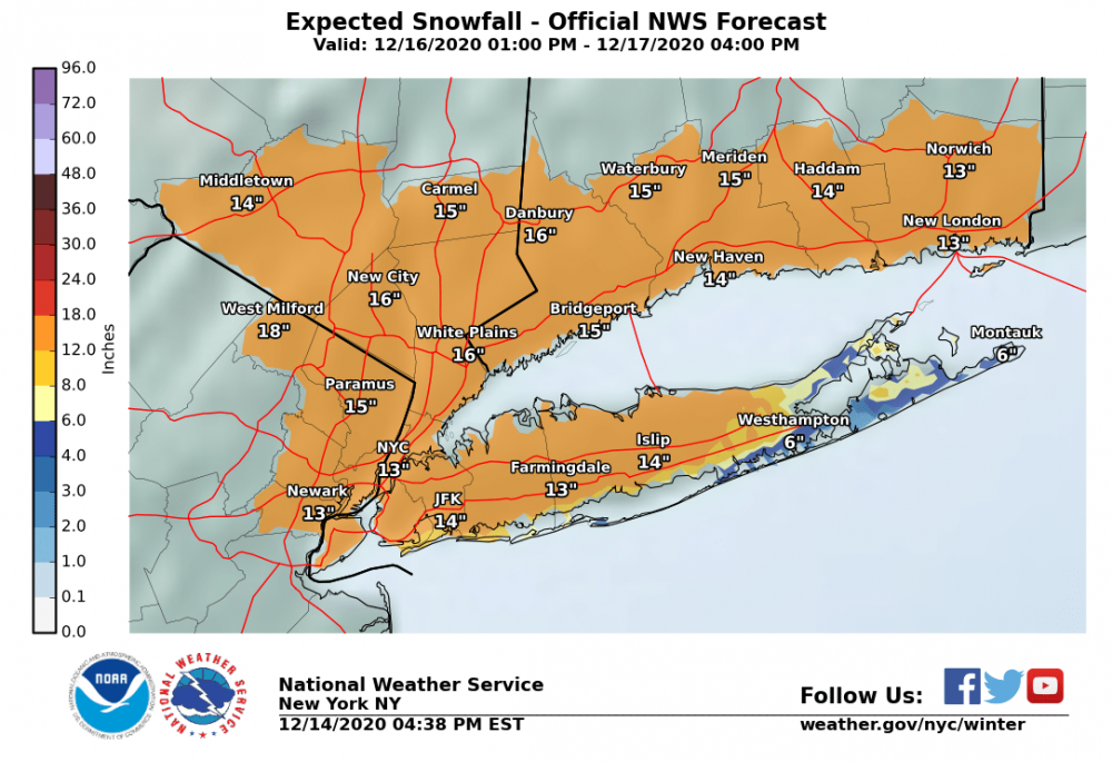
Looks like Upton going with around a foot or just over at this point for most of the NYC area, and sleet or rain cutting things back out east.
- 3,760 replies
-
- 1
-
-
- heavy snow
- heavy rain
- (and 3 more)
-
If the winds stay from a NE direction which is very likely I doubt anyone other than the twin forks maybe see any rain. Coastal NJ will have mostly rain because of NE winds-there that's onshore with warm early Dec waters. As for the sleet, the 700/850 low tracks are key, and there was improvement on the recent NAM/Euro runs.
- 3,760 replies
-
- 3
-
-
- heavy snow
- heavy rain
- (and 3 more)
-
Actually the GFS doesn’t look much different to me at all. The 0.75” liquid line makes it just a hair further north in CT vs 12z? On both runs Boston is just under 0.5” liquid.
-
GFS was always going to trend north. Not much doubt this tries to tuck toward southern NJ-then hopefully sharp east turn. Areas of CT and S NY will do quite well with this-never bought these crazy cutoffs just north of me.
- 3,760 replies
-
- 1
-
-
- heavy snow
- heavy rain
- (and 3 more)
-
I'm not too concerned with it. The Euro/NAM coming southeast was a good thing. And even so the RGEM was pretty nice verbatim for our area. Philly area gets a ton of sleet.
- 3,760 replies
-
- 1
-
-
- heavy snow
- heavy rain
- (and 3 more)
-
S NJ is very unlikely to get much snow from this even if the mid levels cool a little more. Surface winds there coming from the Atlantic are a killer in Dec.
- 3,760 replies
-
- 1
-
-
- heavy snow
- heavy rain
- (and 3 more)
-
The 700 low on this 18z run looks like it tracks just about over NYC and LI, 850 low about 75 miles SE. Good improvement here. I would think this could be enough to keep much mix away.
- 3,760 replies
-
- 2
-
-
- heavy snow
- heavy rain
- (and 3 more)