

Toro99
-
Posts
56 -
Joined
-
Last visited
Content Type
Profiles
Blogs
Forums
American Weather
Media Demo
Store
Gallery
Everything posted by Toro99
-
The tornado watch was issued about 9 minutes before the thunderstorm warning popped up on my TV, I’m sorry, but that’s ridiculous
-
GRR holding off as usual until the storm is overhead to issue any watches
-
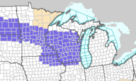
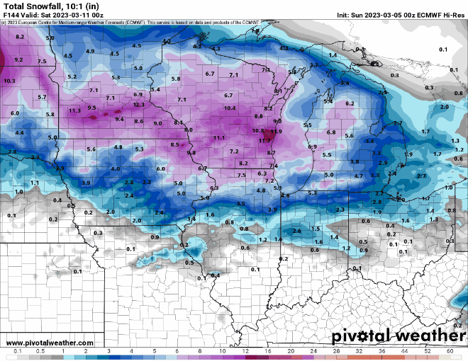
Nov 28-30th Post Turkey Day Winter Storm
Toro99 replied to Chicago Storm's topic in Lakes/Ohio Valley
Flake size and totals signal underperformed so far in SW MI -
Fascinating listen, not sure what to believe anymore.
-
-
They finally went with an advisory for their entire area, in the middle of the night, mid event. Classic
-
Classic screw-you-michigan look to the watch/warning map
-
GRR doing its Braveheart thing as usual.....
-
Probably a bit early, but calling this a massive bust for Southwest Michigan. I have about 5 inches measured, starting at about 2 PM, and now we’re dry slotted. We’ve been under a warning since 10 AM. Not a meteorologist, but just looking at the radar presentation throughout this event so far, it looks like a splotchy disorganized mess, and it has never gotten his act together. If you want to see how the storm was forecasted, look north of Toronto on radar currently, that’s how it was supposed to be here all day and through the night. I know it’s a bit cliché, but I have to believe the southern convection stole a lot of moisture and led to the splotchy precipitation throughout the event so far.
-
Had that the last hour or so, flake size starting to improve and stick a bit just to your SW. Dry air finally saturating, I trust this is just getting going for SW MI
-
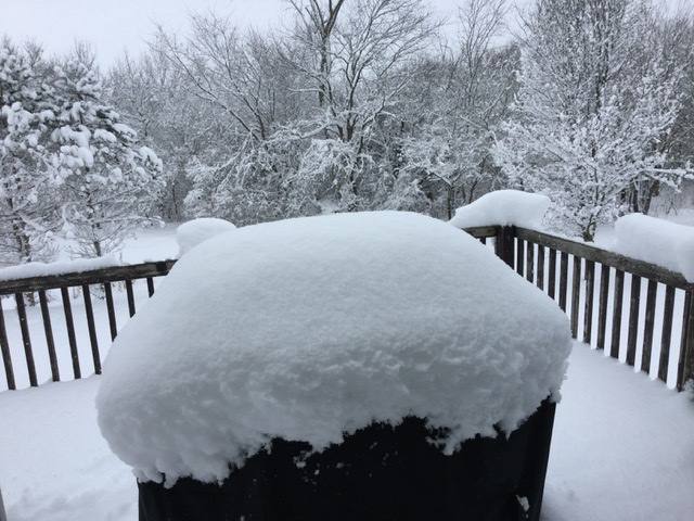
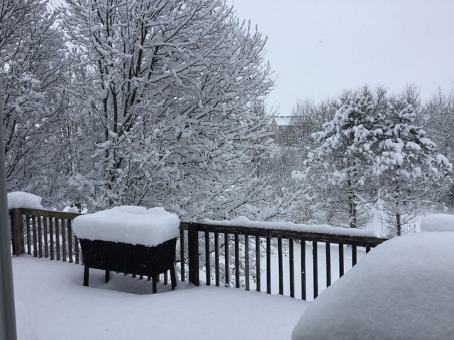
Not sure, but seemed like an over performer here in West Michigan in general. All schools cancelled today, 2nd round really produced here in Jamestown (se Ottawa county). I’ve easily got 4-6 on my deck railing/grill, and most of that was after a brief bit of rain early afternoon. Models seemed to catch on to SE/flatter evolution which helped keep the rain/snow line further south. Beautiful out right now.
-
Winter 2023/24 Medium/Long Range Discussion
Toro99 replied to Chicago Storm's topic in Lakes/Ohio Valley
Posting 384hr maps should be banned, or suspended for a month. Maybe suspend for the number of hours on the posted map -
Models (at times) are irrelevant post Otis. One of the many lessons learned the hard way.
-
Lake Mead ftw
-
Gapped, guaranteed
-
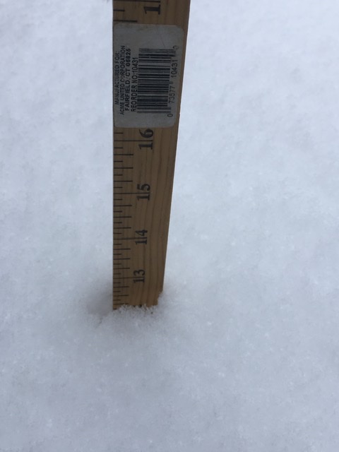
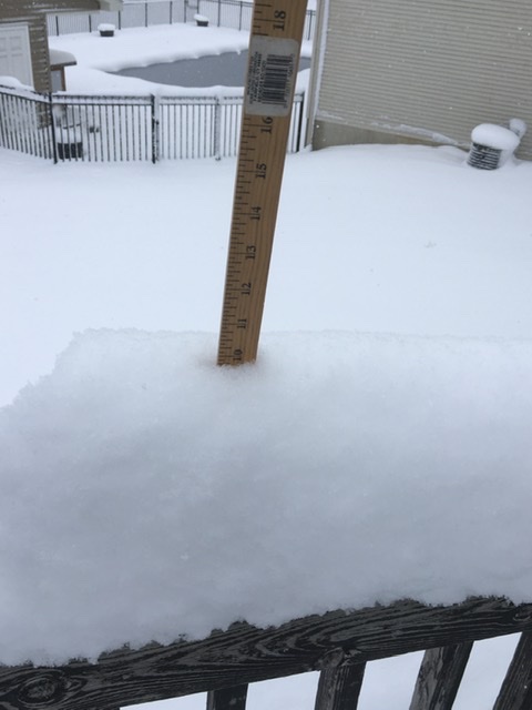
Probably the most gorgeous snowfall we’ve had in as long as I can remember here in Hudsonville, southwest of Grand Rapids. Incredible flake stacking, what an over performer! Over a foot and counting on an elevated deck, and I’ve never seen 10 inches stack on a 1 inch wide deck railing! I am making a mental note of the storm, to remind myself that not every storm underperforms. Should help with my psychological state moving forward.
- 411 replies
-
- 10
-

-
Trends die hard
-
Winter 2022/23 Medium/Long Range Discussion
Toro99 replied to Chicago Storm's topic in Lakes/Ohio Valley
Jaded board = no thread courage -
Don't ever remember seeing a plume spread like this (GRR) at the start of the event: 0" - 17.5", with everything in-between
-
Seriously, borderline theatrical. Chat gpt writing AFDs
-
Omg, the overnight GRR write up is worth a read
-
Winter 2022/23 Medium/Long Range Discussion
Toro99 replied to Chicago Storm's topic in Lakes/Ohio Valley
The number of rain events forecast by the Euro and GFS in the extended range is utterly flabbergasting for this time of year. So disappointing, when a lot of us were counting on February to be our month. Did I just type the word flabbergasting? Good grief, that’s how bad it is -
Pre-Christmas (Dec 21-23rd) Winter Storm Part 2
Toro99 replied to Chicago Storm's topic in Lakes/Ohio Valley
Val-d’Or is the place to be -
Pre-Christmas (Dec 21-23rd) Winter Storm
Toro99 replied to Chicago Storm's topic in Lakes/Ohio Valley
Plumes at the end of their range for GRR are still fun. You know, the office that refuses to issue a wsw.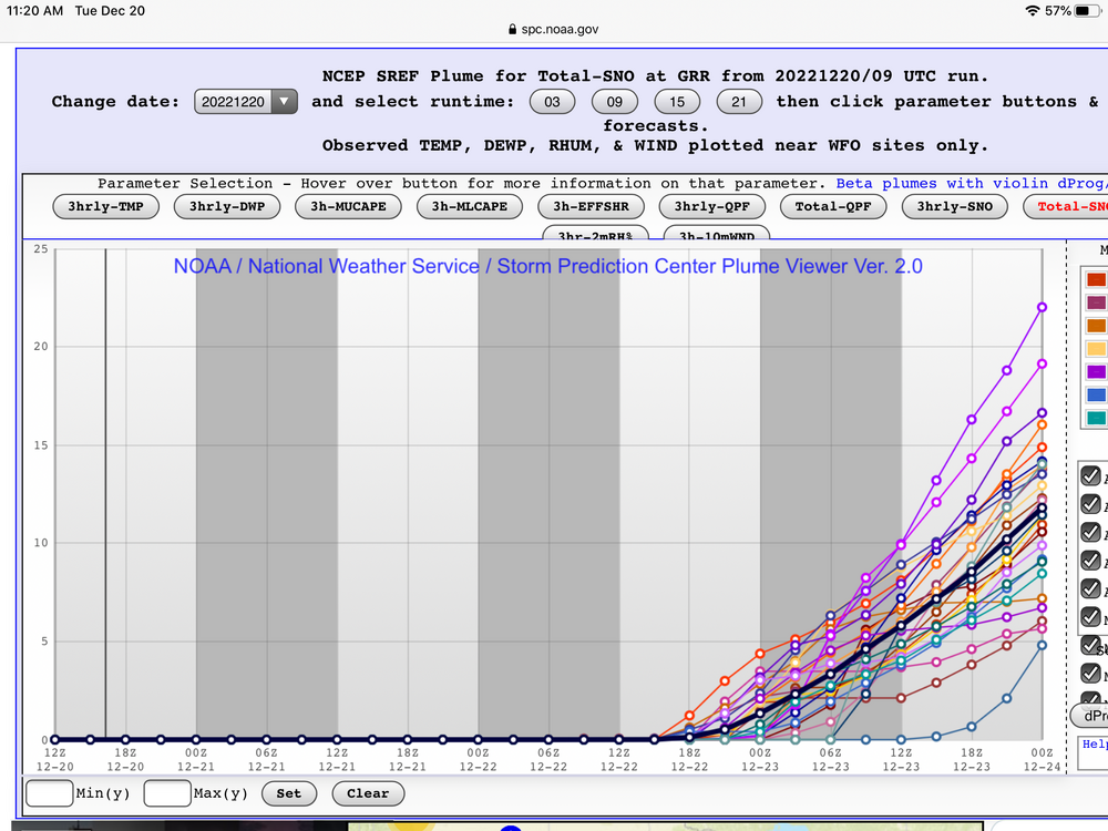
-
Yeah, I had had high hopes when I was in one of those cells this morning, but they don’t last and have been very spotty. Accumulations are probably still on track, but it doesn’t feel like a “warning” type event. Not sure I can remember a long-duration-super-spotty/choppy LES storm. Hoping for more consistency through tomorrow/sat. I mean going from 4”/hr rates with dendrites the size of quarters, to nothing for a couple hours in the heart of a WSW is actually brutal for some reason


