Upstate Tiger
-
Posts
963 -
Joined
-
Last visited
Content Type
Profiles
Blogs
Forums
American Weather
Media Demo
Store
Gallery
Everything posted by Upstate Tiger
-

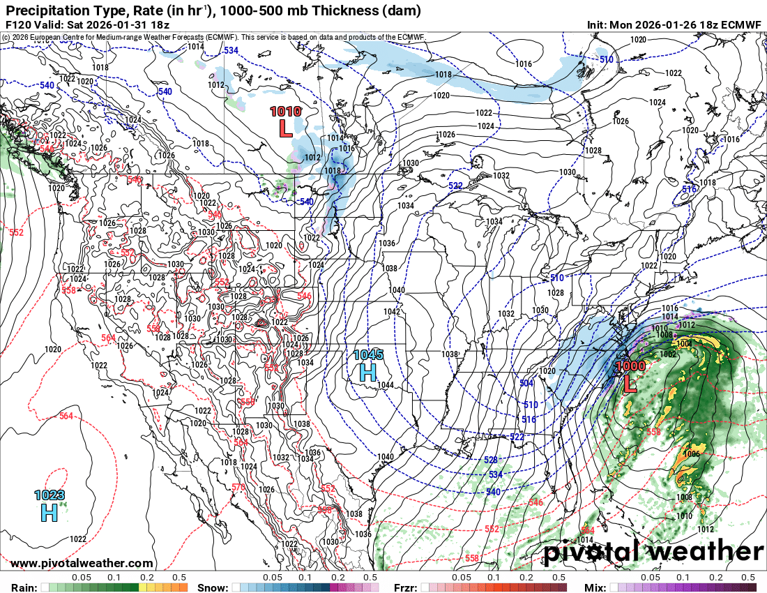
The “I bring the mojo” Jan 30-Feb 1 potential winter storm
Upstate Tiger replied to lilj4425's topic in Southeastern States
He nailed last week's storm... -
The “I bring the mojo” Jan 30-Feb 1 potential winter storm
Upstate Tiger replied to lilj4425's topic in Southeastern States
So we like Bam again? Just want to make sure I am not hating the wrong people... -
77,78,79 all had snow on Super Bowl Sunday in the upstate
-
The “I bring the mojo” Jan 30-Feb 1 potential winter storm
Upstate Tiger replied to lilj4425's topic in Southeastern States
Euros stuck at 54. Boy it must really be cooking up something good (or bad) -
The “I bring the mojo” Jan 30-Feb 1 potential winter storm
Upstate Tiger replied to lilj4425's topic in Southeastern States
06 GFS much better surface reflection. Can someone post the Weathernext? -
The “I bring the mojo” Jan 30-Feb 1 potential winter storm
Upstate Tiger replied to lilj4425's topic in Southeastern States
Need to go back and look at H5. Really thought the surface would have been better with gulf low placement and transfer. The big dogs usually transfer right off shore at the Ga Fl line. Still showing off NC. -
The “I bring the mojo” Jan 30-Feb 1 potential winter storm
Upstate Tiger replied to lilj4425's topic in Southeastern States
We can work with this.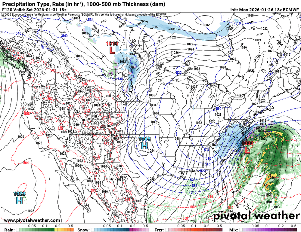
-
The “I bring the mojo” Jan 30-Feb 1 potential winter storm
Upstate Tiger replied to lilj4425's topic in Southeastern States
18z Euro not bad at this range. Shows snow for most of NC. -
The “I bring the mojo” Jan 30-Feb 1 potential winter storm
Upstate Tiger replied to lilj4425's topic in Southeastern States
And unlike 1980, the preceding days will not be mild. -
The “I bring the mojo” Jan 30-Feb 1 potential winter storm
Upstate Tiger replied to lilj4425's topic in Southeastern States
The 3/1/1980 storm was a bit of a disappointment in the upstate. Friday the 29th was sunny and temp climbed to 60. NWS issued a WSW that afternoon and forecast of temp falling to 30 by morning and remaining steady or falling through Saturday, with 8”-10” of snow. The temp was at 30 at daybreak and did drop through the day. But a warm nose kept the upstate sleet all day. We accumulated a couple inches of sleet. Every time it transitioned to snow and we thought the changeover had occurred, it would go back to sleet. We were slightly saved by a ULL that night that gave us a quick 2”-3”. So not a total bust. -
This pattern reminds me an awful lot of January 77. There's a misconception that we had a lot of snow that month but the cold was the real story. It is still the coldest month on record at GSP. The highest temperature recorded at GSP for the month was 50 degrees. 77/78, 78/79, and 79/80 were the trifecta for SE winter storms. 01/3/77 - 1"-2" of snow in the upstate 1/10/77 - Superbowl Sunday, 3"-4" in the upstate, brutal cold the following week 1/15/77 - ice storm 1/17/77 - famous (or infamous) cold wave. Temps in the low to mid teen in the upstate during the day. 1/24/77 - 5" of snow February and March turned warm with above normal temps, so it was really a 4 week stretch that changed the record books. Side note, February 80 is still the coldest February on record in the upstate.
-
The “I bring the mojo” Jan 30-Feb 1 potential winter storm
Upstate Tiger replied to lilj4425's topic in Southeastern States
I am happy with what the models are showing at this point. Personally I would like to see an earlier phase and a Miller A evolution for those of us in the western parts of NC and SC. But I am greedy that way... -
Now it’s serious. A triple dog dare. Josh committed a slight breach in etiquette by skipping the double dog dare and going straight for the throat.
-
Pretty memorable storm. If for no other reason than the vast size of the storm and the amazing CAD. I’ve followed winter storms in the SE for over 50 years and they are all unique. Fun tracking with you guys and gals! Now on to the next one. Have a feeling this winter still holds some surprises.
-
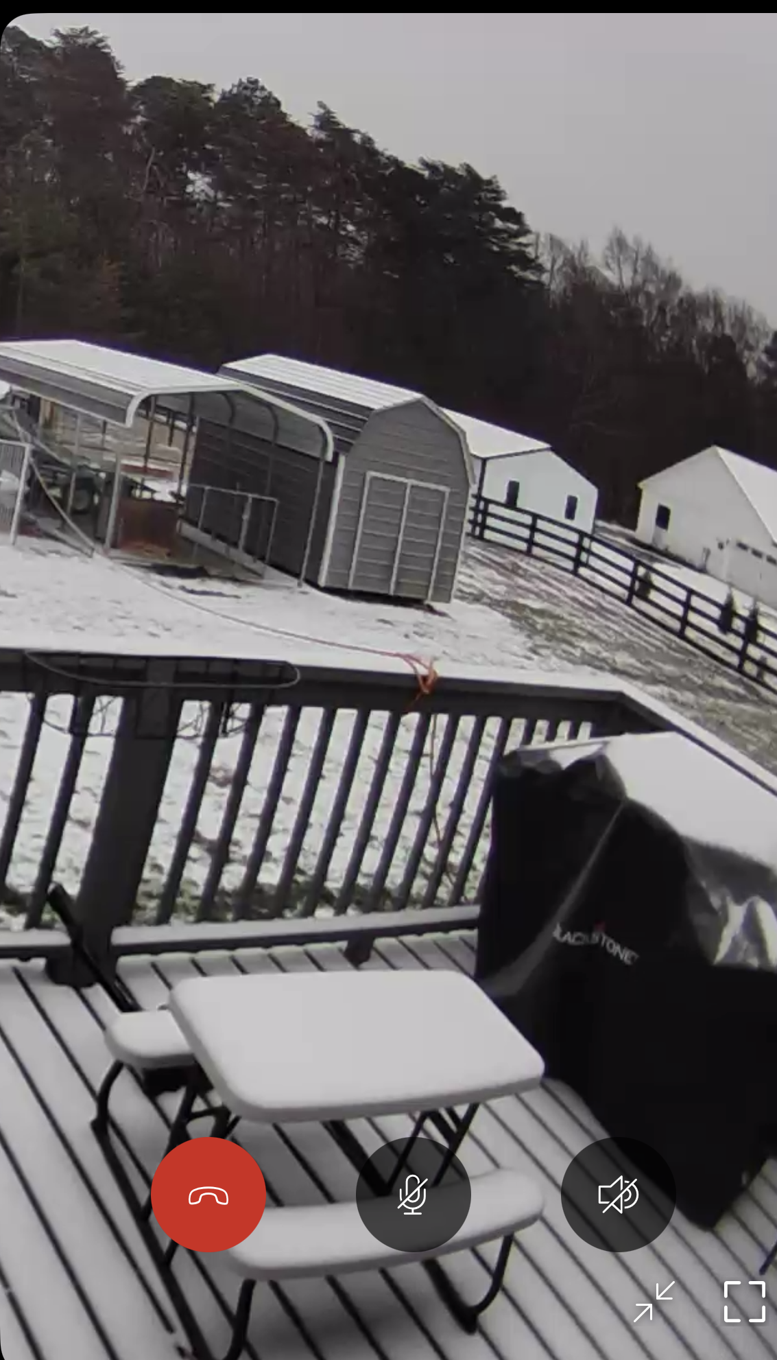
Southern Crippler - Get well soon Jimbo Storm Obs
Upstate Tiger replied to BooneWX's topic in Southeastern States
Is this for real? -
Southern Crippler - Get well soon Jimbo Storm Obs
Upstate Tiger replied to BooneWX's topic in Southeastern States
Heavy sleet in Lincolnton as the line starts to move through. -
Southern Crippler - Get well soon Jimbo Storm Obs
Upstate Tiger replied to BooneWX's topic in Southeastern States
Radar doesn’t look impressive but we’re getting the heaviest snow and sleet since really early this morning. -
Southern Crippler - Get well soon Jimbo Storm Obs
Upstate Tiger replied to BooneWX's topic in Southeastern States
West Lincoln this morning. 18 degrees. Mostly sleet.
-
Next weekend’s potential storm is suppressed. As others have said, probably a good thing at this range. The crazy thing on the models long range is one clipper after another after another. We are going to see some frozen bodies of water that haven’t been frozen in decades.
-
Southern Crippler - Get well soon Jimbo Storm Obs
Upstate Tiger replied to BooneWX's topic in Southeastern States
Snow and 24. Looks like about an inch. -
Southern Crippler - Get well soon Jimbo Storm Obs
Upstate Tiger replied to BooneWX's topic in Southeastern States
Snow and 21 in Lincolnton. Ground white. -
Southern Crippler - Get well soon Jimbo Storm Obs
Upstate Tiger replied to BooneWX's topic in Southeastern States
This is some of the stoutest CAD I’ve ever observed. The source cold is insane. -
Southern Crippler - Get well soon Jimbo Storm Obs
Upstate Tiger replied to BooneWX's topic in Southeastern States
Must have had a little bit of drizzle that coated my truck in the last hour. 24/14 here in West Lincoln. -
January 25/26 Jimbo Back Surgery Storm
Upstate Tiger replied to Jimbo!'s topic in Southeastern States
I remember that happening in the upstate in the late 70s -
January 25/26 Jimbo Back Surgery Storm
Upstate Tiger replied to Jimbo!'s topic in Southeastern States
GSP has issued an Ice Storm Warning for my area in Lincoln County (NC Piedmont).