wxmeddler
-
Posts
7,044 -
Joined
-
Last visited
About wxmeddler

Recent Profile Visitors
7,620 profile views


-
Getting a little worried about the Sunday / Monday rain event... the setup seems fairly primed to produce flooding somewhere in the ridge/valley and piedmont region.
-
Yes. Next question... It honestly has to do with the experience of the person in the hot seat. The operators down in Oklahoma / Texas / Kansas etc. are good because they've had the reps. As you move east there is a tendency over warn just because of the lack of events to get practice on what does and does not produce. The training is helpful but provides 50 cases at most. You really need hundreds / thousands to get good.
-

2026 Mid-Atlantic Severe Storm General Discussion
wxmeddler replied to Kmlwx's topic in Mid Atlantic
Trees are the real killer to reliability. A major issue is that we're getting to the point in some of the older suburbs / planned communities that the trees planted at the time of housing construction are reaching the post-maturity age. They are going to fail/fall, and unless the landowner / HOA / town / county is on top of it (they are not), then you're gonna get outages with 30 mph gusts.- 1,685 replies
-
- 2
-

-
- severe
- thunderstorms
- (and 7 more)
-
2026 Mid-Atlantic Severe Storm General Discussion
wxmeddler replied to Kmlwx's topic in Mid Atlantic
- 1,685 replies
-
- 2
-
-
- severe
- thunderstorms
- (and 7 more)
-
Hi, Yes. We're in active discussions about multiple sites in the county(ies). Hopefully something soon.
-
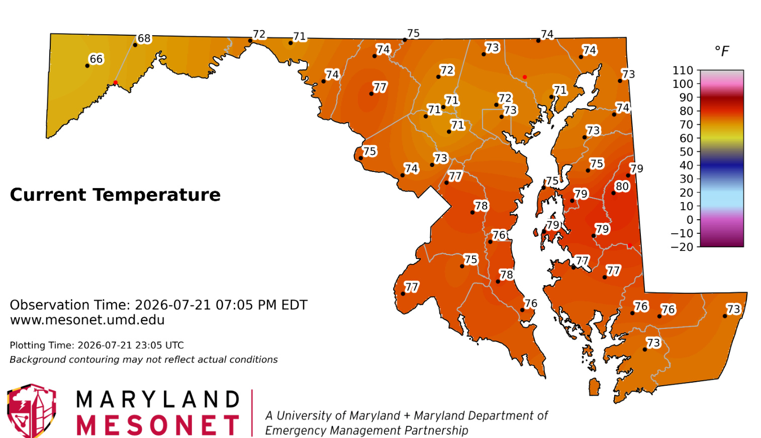
Quite impressive that most areas didn't get above 80. The high clouds staved it off.
-
Today was a great day to work outside. Still a touch warm for my liking on where I was on the eastern shore. Prefer 72 over 82 with full sunshine this time of year but I'll take what I can get with these dew points today.
-
2026 Mid-Atlantic Severe Storm General Discussion
wxmeddler replied to Kmlwx's topic in Mid Atlantic
Just rain and wind from here on out mostly. And most of the wind threat will likely be US50 and south. -
2026 Mid-Atlantic Severe Storm General Discussion
wxmeddler replied to Kmlwx's topic in Mid Atlantic
The atmosphere is pretty well turned over at this point. Not sure we're going to get much more in the way of tornadoes unless it's some QLCS / bookend thing.
-
2026 Mid-Atlantic Severe Storm General Discussion
wxmeddler replied to Kmlwx's topic in Mid Atlantic
Very obvious TDS west of Winchester. LWX has gone radar confirmed.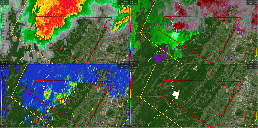
-
2026 Mid-Atlantic Severe Storm General Discussion
wxmeddler replied to Kmlwx's topic in Mid Atlantic
The best looking hodographs come in around 20z and last through about 3z. Eastern shore looks thermodynamically best right now given the satellite but the are better hodographs west. Convective temperatures are around 95F -ish, and we're not gonna get there in N/W of I-95 with the clouds. This is all for semi-isolated supercell stuff... if you just want a thunderstorm, you'll get a good chance of that everywhere later.- 1,685 replies
-
- 1
-
-
- severe
- thunderstorms
- (and 7 more)
-
2026 Mid-Atlantic Severe Storm General Discussion
wxmeddler replied to Kmlwx's topic in Mid Atlantic
That looks like 65 mph damage, there were pockets of 80 in there from TDWR. Locally more damaging than the '12 derecho. I think the derecho only had 50-65 in the Pasadena / Rivera Beach area. -
There was quite blue skies this morning, but it's gotten progressively worse as the day goes on. Smoke and haze.
-
2026 Mid-Atlantic Severe Storm General Discussion
wxmeddler replied to Kmlwx's topic in Mid Atlantic
More bulk shear and more low level curvature. 10-15 kt southeaserlies at the surface with 20 kt southerlies at 850 would have done the trick for tornadoes. Mid-Level dry air pocket for more widespread winds.- 1,685 replies
-
- 1
-

-
- severe
- thunderstorms
- (and 7 more)
-
That's over where my parents live... my mom said the traffic light was out at Lake Waterford Park. Yeah, most of the damage was north / east of MD100 / MD10.