

mahantango#1
-
Posts
5,079 -
Joined
-
Last visited
Content Type
Profiles
Blogs
Forums
American Weather
Media Demo
Store
Gallery
Posts posted by mahantango#1
-
-
52 minutes ago, pasnownut said:
Or go look at nooner GFS. Beatdown incoming.
We need that come up about 60 miles north and west!
-
 2
2
-
-
18 minutes ago, AccuChris said:
The NAM is just odd. It literally shows nothing

.Maybe we should start raising the flag with the fork on it. Quite a few letdowns again this winter.
-
46 minutes ago, Voyager said:
What a warm up...
I know the forecast temps dropped toward late week, but damn, it's 35 and damp as hell this morning. It almost feels worse than the previous frigid cold temps the past few weeks.
And it again it's been cloudy for awhile.
-
1
-
-
-
From DT: and his video about 25 min ago he's still calling bull on the gfs.
Yes I saw the 18z wed op GFS . There is a better chance of monkeys flying out of my ass on Sunday night then that model verifying.
-
From DT:
THIS WEEK IN WX VIDEO TONIGHT
LETS MONGER ABOUT SUNDAY MONDAY POSSIBLE EAST COAST WINTER STORM
Just to give you all a clue…..Yesterday and again this morning and again this evening. NOAA/ NWS flew reconnaissance aircraft into the eastern Pacific to get a better sampling of the upper atmosphere and to make up for the loss of data from closure of several key weather stations in the upper planes in Midwest, which used to end up with the balloons to gather information about the atmosphere.
The fact that the national weather service had to send out extra planes into the eastern, pacific to gather this data speaks to how badly the overall weather models have performed recently because of the lack of information from the weather stations that have been partially shut down in the upper Midwest.
Guess what happened when they flew those planes and gather the extra data? They were a huge changes in what the models are showing is going to happen for Sunday Monday. Full details and discussion tonight on the weather video around 1030pm
-
-
53 minutes ago, Voyager said:
I'm sorry, but after a month of dirty, salty roads, if this rain this week washes them clean, I don't want it to return.

-
-
3 hours ago, canderson said:
Oddly precip ended up not being an issue - many areas had nearly .25” rain Sunday.
I clocked in at .14”.
Same amount of rain here .14
-
Looks like between 2-4 inches of the snow, ice pack left on the ground (at my place) to melt this week. The snow piles...thats a different story.
-
14 minutes ago, Jns2183 said:
@canderson March and April are coming up. For wind weenies like you it's mecca
Sent from my SM-S731U using Tapatalk
Please no more 20 to 50mph winds.
-
1
-
-
44 minutes ago, Voyager said:
So. I did more measurements...
Backyard walkway: 2"
My white GMC: 2.5"
My neighbor's blue Ford: 2.25"
Congrats on this astounding snow victory!

-
 1
1
-
-
22 minutes ago, Voyager said:
That would be my range. I just woke up, got a coffee and a smoke, and went out back. I measured 2 inches on the backyard walkway. Might have been a little more if I actually had a snow board, because it initially was melting on contact on paved surfaces. I'd probably get a truer measurement if I went out front and measured on one of the cars.
If I look closely I can see it snowed on the exposed grass in the yard that I shoveled from the January snowstorm. On to the next threat of snow.
-
Wet snow here and 34 degrees.
-
2
-
-
9 minutes ago, Voyager said:
Cars caved. Sidewalks caving Street? Not yet, but it's snowing big fatties right now, so it's just a matter of time.
Rain here.
-
5 minutes ago, canderson said:
CTP has hinted at very minimum precip all week and ultimately that’s the kill shot.
I of course am happy so I don’t empty my innards starting In a few hours for naught lol
Enjoy your prep mixture. Too bad they don't recommend mixing it with vodka, or some other kind of alcohol. That would make the experience better when your shitfaced getting to the bathroom.
-
 1
1
-
-
-
After a bitter cold stretch from late January through early February, who doesn't love a welcomed warmup for #ValentinesDay and the days following? Asking for a friend. #PAwx

-
from NWS this morning:
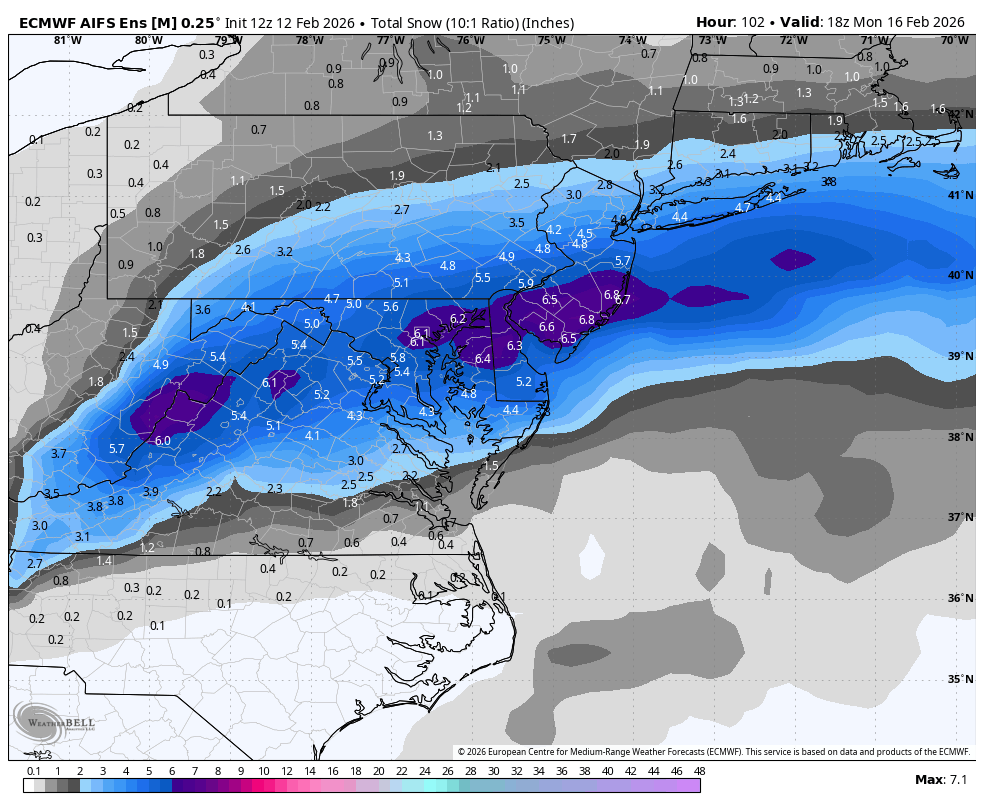
The other tricky aspects of the fcst include: relatively warm
boundary layer/road temps, precip rates/banding, onset timing,
elevation, and wet bulb effects. Without going to far into the
weeds, the key takeaway for this cycle is that odds have
increased on the margin for accumulating wet snowfall across
south central and particularly southeast PA Sunday afternoon
into Sunday night. The largest % chance increase is for areas
to the east of I-81 with WPC, RRFS, and NBM showing low to
moderate chances (30-50%) of snowfall totals >1 inch. The
official NDFD fcst initialized off of the 14/01Z NBM is likely a
bit too low at this point and would anticipate/front-run an
uptick in POPs and snow amounts to be more in the C-1" range
with the next cycle. There is the potential for additional
changes to this forecast in the next 12-24 hours so continue to
monitor especially for possible early Monday morning commute
impacts.
-
4
-
-
Is it me or is anybody else noticing that the snow cover is getting less, but I don't see any puddles or runoff. It just seems to be evaporating.
-
1
-
-
Our Climate Watch Fearless Forecast calls for no more than 5 of the next 28 days to feature high temperatures 8º or more below average. And not as dry in Pennsylvania as recent weeks.


-
1
-
-
10 minutes ago, Itstrainingtime said:
You posted 6z...12z is even better!
Is there any other model support for Sunday? We need an February 1983 repeat
-
24 minutes ago, Itstrainingtime said:
Even down here, my forecast on Thursday evening (night before the storm) was for "4 or more inches, with the potential for as much as a foot" - the following day, 24.5" fell.
NWS kept updating the amounts during the storm.
-
 1
1
-


Central PA Winter 25/26 Discussion and Obs
in Upstate New York/Pennsylvania
Posted
Capital Weather Gang:
We're going to get out ahead of this because we know we'll get questions. No, we do not believe the GFS (American) model (just in), which shows 3 feet of snow for DC Sunday-Monday. It is ranked 4th for accuracy for a reason + not supported by other models which generally show a modest event. We'll post our analysis of what's most likely early afternoon today.
Posted 11a Thursday.