

mahantango#1
-
Posts
5,079 -
Joined
-
Last visited
Content Type
Profiles
Blogs
Forums
American Weather
Media Demo
Store
Gallery
Posts posted by mahantango#1
-
-
-3 here this morning.
-
 3
3
-
-
JB said last night he has no changes on this hitting us. But he also said he might have to abandon his idea also. But right now this idea of a storm here, looks like burnt toast
-
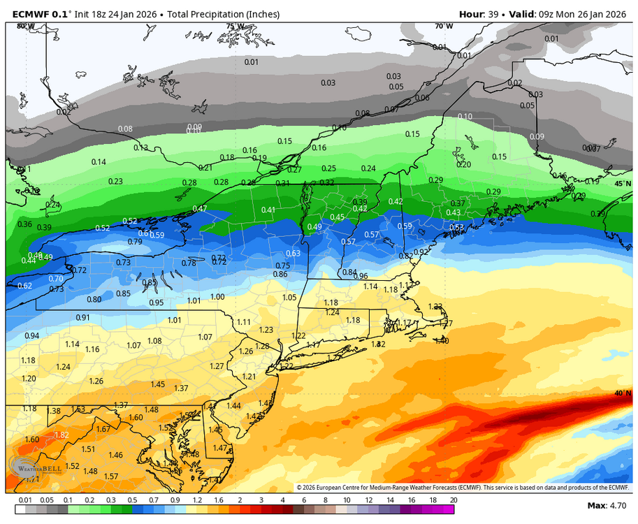
FollowLATE MON/ EARLY TUE UPDATE ON JAN 31- FEB 1 POSSIBLE SEVERE EAST COAST WINTER STORM THREAT /1 This is a discussion -NOT a forecast. 0z early Monday (1AM) op-Euro/ 6z op-EURO/ 6z Euro all develop a massive VERY powerful East Coast winter storm that deepens 975mb with winds over 45 mph.12:43 AM · Jan 27, 2026Everybody can reply12along with an incredible snow amount from Central NC to new England. BUT that is 1 **possible** outcome. The question is HOW does the Euro model do this ?? First It should be pointed out that other models are showing SIMILAR OVERALL solutions in various degrees. /21Not surprisingly most of the GFS and GFS AI model runs have the MASSIVE Intense LOW somewhat further east (Typical behavior with th GFS mode and BIG East Coast LOWs) This image shows how this massive storm COULD develop in to bring about such an extreme snowstorm in the this weekend. /31The first map shows a major s/w ( shortwave) running W-E from Iowa to the Great Lakes on Friday. This feature develops a closed 500 low that rapidly rotates as it heads SE. It swings around in SW- NE alignment, then a N to S, then NW-SE ( negative Tilt) alignment. /4 SEE IMAGE 21The 500mb Low develops a negative Tilt ( NW-SE) and " captures" the surface LOW off SC and pulls it NW. The surface LOW reaches max size /intensity FEB 1 when the 500mb LOW the surface LOW become vertically stacked off of DEL / 51Note on MAP C the 500 LOW tracks across NC then turns NE off the NJ coast and captures the surface Low. THAT IS THE KEY- any variation causes a big change with how the LOW develops & which part of the coast gets hit. The 18z Monday Euro; note the 500 LOW is in SC - NOT NC /61This would allow the surface LOW to the captured further to the east which would mean the big cities of I-95 from Boston to DC wouldn't miss out on the best snows while eastern VA / eastern NC and Cape Cod would get blasted. /7 See 18Z op EURO118Z EURO ensemble has significant cluster of LOWS further West /8
-
2
-
-
1 hour ago, canderson said:
Another day, another day with winds 15 mph above forecast. Blowing 40.
I'll say it again and again, I had enough of this wind.
-
1
-
 1
1
-
-
Now with this sleet on top of the snow will it drift when winds pick up tomorrow? I seen wet snow drift after the winds dried it out.
-
That sleet on top of that snow made it heavy to shovel.
-
1 minute ago, Blizzard of 93 said:
Dare I say… best rate & flake size now in Marysville!
Same here as well!
-
1
-
-
Mostly snow here with some sleet. Almost 9" accumulation so far today.
-
6.75" snow so far.
-
1
-
-
-
NWS State college is live now on Facebook.
-
2 minutes ago, Blizzard of 93 said:
Hopefully the sleet stays away.
-
4 minutes ago, whiteout said:
Where are they hosting this?I think on Facebook, thats where I got the post.
-
US National Weather Service State College PA's
We plan to go live at 9 AM to provide a brief update on today's significant winter storm. Check back here at 9 if you're interested!
-
 1
1
-
-
I'm wondering just how far north the sleet will make it in The Susquehanna Valley?
-
8 minutes ago, Blizzard of 93 said:
Juiced up!
We need this for the drought
-
1
-
-
3 minutes ago, Blizzard of 93 said:
Current dew point st MDT is -7
Impressive air mass that should help us.
My dp is -0.6
-
We're probably less than 12 hours from the onset of our first major snowstorm in years. I hope you all enjoy no matter the outcome
-
6
-
 1
1
-
-
Bernie Rayno said this morning that he thinks the sleet will have a tough time making inroads on these negative dewpoints. But he said he's been wrong and right before on similar situations. That's his personal opinion.
-
1
-
-
Nws introduced snow possibly mixed with sleet tomorrow in my forecast for tomorrow evening from 6to10pm
-
1 hour ago, Itstrainingtime said:
82/70: Key Largo
That sucks you have to deal with that summer heat and humidity. Come back home to reality where it's 14 here.
-
8 minutes ago, canderson said:
The last GFS lost the weekend blizzard in its entirety lol
Sometimes the GFS gets lost. Remember just a few days ago where it has the storm. I guess we'll see if the models come around.
-
1
-
-
2.5 was my low.
-
Just now, canderson said:
Might not break 20 degrees for the next 8 days
This is gonna be brutal. After years of relative so called mild winters, this is gonna sting.


Central PA Winter 25/26 Discussion and Obs
in Upstate New York/Pennsylvania
Posted
Wow!