

mahantango#1
-
Posts
5,079 -
Joined
-
Last visited
Content Type
Profiles
Blogs
Forums
American Weather
Media Demo
Store
Gallery
Posts posted by mahantango#1
-
-
I remember this storm very well. Original forecast was 1-3 than 2-4 till it was all set an done i received 18 inches. I think Harrisburg got 24 inches. There was Thunder and lightning during the storm. February 10-12th, 1983:
Called the “Megalopolitan blockbuster snowstorm,” this major snowstorm impacted the Mid-Atlantic and southern New England. Snowfall of up to 25 inches fell in Allentown, Pennsylvania. Snowfall of 35 inches occurred in parts of the Blue Ridge Mountains of West Virginia at Glen Cary. Windsor Locks, Connecticut, recorded a record 19 inches in 12 hours. A ship sunk off the Virginia/Maryland coast, killing 33. There were 46 total storm-related fatalities.-
 1
1
-
-
-
30 minutes ago, Voyager said:
There was a big time wind shift around 1:00pm in Hazleton. A West wind that was blocked by the water silos turned into a north wind that's now blowing a blizzard of the roof of the plant.
Of course the fallout ends up right where the unload hose hooks to the truck.
You have to a long talk with mother nature again as it is cloudy all day again. You have to stress to her we need sunshine
-
1
-
-
Wind now gusting to 34mph.
-
1
-
-
4 minutes ago, pasnownut said:
and that MU dude wrote it off with his arrogant undertones yesterday....so there's that.
With NAO headed pos, my worry is and has been that this thing lifts far enough to wash away my hopes for white gold.
Seems like every winter we go through this several times, trying to determine if the storm is coming north. Time will tell if we get this one. I hope we do. But something tells me we won't. So I guess it's 50, 50 right now.
-
1
-
-
JB is not changing his stance on this potential storm coming north...yet.
The Euro at 06z is coming back, but now its north. It was shoved south yesterday. This is why I have not changed my idea on this until I see this get into the west coast. So only long range forecast, that started on the 4th has not changed yet for this potential. If I have to change it I will change it once but not till I see the reality of the feature that arrives Thursday or Friday, not with every flipping model run
That does not say I am right. Every one of you who has written this off COULD BE SPOT ON RIGHT!!! You may have had it all the way and I would have been wrong all the way. So I am not saying you are wrong. Nor am I critical of you because you have the opposite stand to mine. I just wonder if you would quit if you were looking at it the way I do. You see, I see what you do. I see all the models too. But the weather is the greatest teacher of what the apostle Paul said:" Those who know what they know don't know what they ought to know". That goes for me. If on Friday I have to eat crow, it means I did not know what I ought to know. But what you ought to know is never obvious, and in a way ,modeling is something obvious.. The consensus is always there. So I see it just like you. I am just showing that perhaps there is merit in taking the time to take a stand and holding it until you are sure. So I am not good enough to be sure that I was wrong, and still think after the work put in I could be right. So until I see what things look like tomorrow and Friday, no changes in this idea that started Feb 4
-
2
-
-
 * An extreme winter in D.C. — the harshest in at least a decade *The Midwest Regional Climate Center tracks seasonal harshness using the Accumulated Winter Severity Index, which accounts for both the intensity and longevity of cold and snow.So far this winter, D.C.’s rating on the 0–5 scale: 5 — Extreme.That’s the highest rating here in the past 10 years.Even if the rest of winter turns mild, the damage is done. Based on what we’ve already endured, the season is locked in at at least a 4 — Severe.
-
1
-
-
4 minutes ago, Blizzard of 93 said:
6z Euro continues to be on board with a slightly warmer & more tucked low position near the DelMarVa before it exits off of the coast.
It still brings warning level snow to the Harrisburg area this run.
If we end up with this track, I like our chances.


I guess if it verified it would be a heavy wet snow.
-
1
-
 1
1
-
-
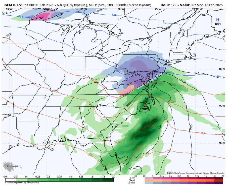
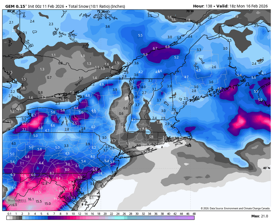
Weekend Storm UpdateDespite what you might have heard…I am STILL tracking the potential for a significant snow event this weekend. If it happens, the snow would arrive Sunday afternoon/evening. Model Guidance has been all over the place but I’ve been fairly consistent with my message: This looks like a Miller B Nor’Easter.Miller B storms typically have a mix line that sets up along I-78/I-80 in eastern PA and NJ.The European Model suggests that mix changes over to heavy snow as this storm strengthens.Whether or not that actually happens is pure speculation at this point. There are some non-linear processes that need to go exactly correct for this storm to produce significant snow. If not, the storm could miss off to the south. So nothing is set in stone yet, but the threat remains.~Meteorologist Mark Margavage
-
2
-
-
Just now, Blizzard of 93 said:
If the 12z models are board, they will be updating again later today.
Theres still time to score, no need for the hail-mary...yet.
-
1 minute ago, Blizzard of 93 said:
It’s not me…
I am showing what the models said…
I know, seems they are really downplaying the event this morn.
-
-
2 hours ago, Blizzard of 93 said:
0z Canadian is still on board as well & has not wavered much the last couple of days.
NWS will tend to disagree with you.
-
 1
1
-
-
36 minutes ago, Voyager said:
Interesting little temp spike this morning. It was 30 at 4:00am, then it went up to 36 at 5:00am, and now back down to 33 at 5:45am.
Were in the middle of a heatwave!
-
 1
1
-
-
Decided to walk down to the creek and take some pictures while there still ice on the creek. That was the easy part. What wasn't easy was walking through that snowpack. Cardio workout for sure was not anticipated. I wonder just how thick the ice is? Questions remain. How long will the ice stay with warmer temperatures forecast? Will the ice slowly melt away? Will we get more snow adding to more water content to the snowpack? Or will we get a big sudden thaw with a huge rain storm? And then will we get the ice breaking up and producing ice jams and flooding? These questions will be answered in the coming weeks.


-
7
-
-
1 hour ago, Yardstickgozinya said:
The good news is NWS has Increased their confidence in a winter storm during Sun-Mon timeframe. The bad news is NWS has lowered confidence in the occurrence of precipitation Sun-Mon. Once again they're getting all the angles covered.

Area Forecast Discussion
National Weather Service State College PA
444 AM EST Tue Feb 10 2026

.WHAT HAS CHANGED...
* Increased confidence in winter storm during Sun-Mon timeframe
* Holding off on any winter weather advisories for possible ice
  accums for E/NE this evening-SW later tonight

&&

.KEY MESSAGES...
1) Light precip possible later today and this evening, with
light post-frontal snow showers and gusty winds over the
Alleghenies later tonight through Wednesday night.

2) Lowered confidence in occurrence of precipitation Sun-Mon.
Confidence in timing of possible precip is slightly higher.
Confidence in precip types/amounts remain low
I have now lowered my confidence in them as they have increased confidence in lowering confidence.
-
1
-
2
-
-
6 minutes ago, Blizzard of 93 said:
Here are CTP’s thoughts on the Sunday Winter storm chance.
KEY MESSAGE 2: Risk managing potential for Valentine`s Day
weekend storm

Aside from the 09/12Z GFS to some extent, an ensemble consensus
including ECMWF, CMC, NBM, and AI runs would lean toward an
increasing potential for wintry weather arriving by the second
half of Valentine`s Day weekend. That said, there is still plenty
of time and space between now and then. Wintry weather/impacts,
particularly details surrounding how much and what ptypes, are
uncertain/unclear. Confidence right now is on low side, but the
potential certainly exists and will need to be monitored in the
coming days.
Some tv mets. are writing the storm off.
-
1 hour ago, canderson said:
More 35-45 mph winds Tuesday night through Wednesday night.
Oh great!
-
40 minutes ago, RedSky said:
Soil? what does that even look like
I guess we'll know in over a month what that looks like.
-
-
27 minutes ago, Voyager said:
+5 here, but as I moved the Wunderground map westward, I saw the crazy negative numbers to the west. It looked like mahantango was in the minus double digits as well.
Only -5 here might drop a degree till sunrise.
-
25 minutes ago, Voyager said:
+5 here, but as I moved the Wunderground map westward, I saw the crazy negative numbers to the west. It looked like mahantango was in the minus double digits as well.
Only -5 here might drop a degree till sunrise.
-
1
-
-
34 minutes ago, canderson said:
It’s still windy - gusting into low 20s - that might help cap temps (again).
Winds calmed down here, but you living near the river, I understand wind speed there will be higher.
-
1
-
-
Gonna be a very cold night tonight.
-
1
-


Central PA Winter 25/26 Discussion and Obs
in Upstate New York/Pennsylvania
Posted
I think Harrisburg had that too if my memory serves me correct.