

mahantango#1
-
Posts
5,079 -
Joined
-
Last visited
Content Type
Profiles
Blogs
Forums
American Weather
Media Demo
Store
Gallery
Posts posted by mahantango#1
-
-
If it keeps snowing like it is now till tomorrow morning, we won't have anything to worry about. Seems where i'm located at I might be in the screw zone. Even though I'm technically in the WSW.
-
5 minutes ago, Storm Clouds said:
SMH idiots…why are they using a SERF mean snow map? Probably because it shows the most snow…
I guess I woke the forum up.
-
 1
1
-
-
LATE SEASON WINTER STORM IS ON TRACK TO AFFECT OUR AREA !!!**ANY CHANGES IN TRACK WILL AFFECT TOTALS SIGNIFICANTLY.**WE WONT KNOW THIS UNTIL THIS EVENING WHEN THE COASTAL LOW FORMS OVER THE ATLANTIC OCEAN.Just a few REMINDERS! @8 AMBlizzard Warning For PHILLY AREA was added overnight!Keep in mind these few key points…..1. Precipitation will start this morning for many as light Rain or Rain/Snow. THIS IS AND WAS EXPECTED!2. STORM will not be very impressive until LATE afternoon or evening around 3-6 PM. Once the sun goes down the coastal storm will gets its act together and rapidly strengthen. This will allow precipitation to get thrown our way from the ocean and that’s when accumulating SNOW will begin to pile up. Best time for accumulation snow to fall will be OVERNIGHT tonight into Monday.3. **REMEMBER** A slight change in track can make BIG changes in totals.A more WEST track would give us higher snow totals AND a track even SLIGHTLY EAST would LOWER totals.LET THE EVENT PLAY OUT!!***This storm will take time to get organized and cranking. Be patient and LET THINGS PLAY OUT! It will be SLOW GOING until AFTER SUNSET.We are watching and waiting!A STORM THIS SIZE DOES WHAT IT WANTS!Stay Tuned! we Will update throughout the day!!!! (AS NECESSARY)Please consider donating to our Coffee And Food Fund! We are Exhausted but we will keep going and keep you SAFE!We truly appreciate your support!Please Copy And Paste Our Name to avoid copy cat accounts!Venmo: @ssstormchasingllcCashApp: $SSSTORMTEAMGOD BLESS AND STAY TUNEDEnjoy The EARLY MORNING SHORT RANGE SHREF MODEL!#TeamSS-LLC-2026

-
12 minutes ago, Voyager said:
Sure wish this forum would wake up a bit. The Philly and NYC forums are quite active, and as such I'm having to go to them for analysis, obs, and general commentary.
The forum would surely wake up when you start talking about 90 degree heat and 77 degree dewpoints and aa heat index of 115.
-
3
-
 1
1
-
-
Down to 27 here.
-
5 minutes ago, Yardstickgozinya said:
Yeah, that's kinda strange. I believe your east of me and my p&c has 2 to 6 inches total . Nws has also been putting quite an emphasis on their lack of confidence and the possibility of extremely varying accumulations over short distance.
I'm located in Northern Dauphin County. I can throw a stone across the creek into Northumberland county. Yea all these forecasts are all over the place.
-
 1
1
-
-
All this talk of snow. My NWS forecast has not changed even with the WSW it's still saying 2-4.
-
Good ole SS:
 READ THE ENTIRE UPDATE!!!
*THIS COULD BE A BLIZZARD *OR*THIS MAY ONLY BE A FEW INCHES.***WE DON’T KNOW JUST YET***————————————————-**STORM MODE ACTIVATED**————————————————-**THIS FORECAST COULD EASILY CHANGE TODAY** STAY TUNED!!!————————————————-**WE SIMPLY DON’T KNOW THE TRACK DUE TO MODEL SPREAD!————————————————-PREPARE FOR THE WORST AND HOPE FOR THE BEST!————————————————-STARTING: SUNDAY DAYBREAKENDING: MONDAY DAYBREAK(HEAVIEST SNOW LATE SUNDAY)————————————————-WHAT: VERY HEAVY WET SNOW!AMOUNTS: 6”-30” Depending on your location and the track of storm.Areas along 83 may see close to a FOOT while areas WEST of 83 may only see 4-8”. Areas near I-95 may see 2-3 FEET (Maybe More). Highest amounts of 2-3 Feet will likely be near the coast! If the storm shifts east heavy snow will move out over the ocean. If it shifts west heavy snow will move over Central Pennsylvania. There are so many variables and we do not know.—————————————————-WE BELIEVE MANY PEOPLE FROM 83 AND POINTS EAST will “LIKELY” see significant WET snow!HOWEVER that’s NOT a guarantee!**Models are all over the place!!!**Look at these models and you will understand. THERE IS A HUGE SPREAD in totals and not much model agreement. There’s ALSO TIME today for TRACK changes to happen.We are monitoring all the data that comes in and we’ll get it out to you as fast as possible. We are now in storm mode and we will not answer many questions, but we will get the info out as fast as we can. Please understand this is an extremely difficult forecast. There is no way in this world for anyone to know which way this storm could track or wheel track. Just now that this is an extremely powerful and dangerous storm and a track west or east will change this forecast drastically. Someone will get 24 feet of snow!-This storm is so big and powerful it will wobble and just a slight wobble WEST will SHIFT huge totals over SCPA. YES THAT IS A POSSIBILITY!!! BUT, we don’t know and likely WONT KNOW until the event is happening!!!WE STRONGLY SUGGEST GETTING SOME GROCERIES AND SUPPLIES IF YOU ARE NEAR 83 & POINTS EAST!!You may not need them but time is running out and it’s better to be prepared and not need it !!!We are monitoring all the data that comes in and we’ll get it out to you as fast as possible. We are now in storm mode and we will not answer many questions, but we will get the info out as fast as we can. Please understand this is an extremely difficult forecast. There is no way in this world for anyone to know which way this storm could track or wheel track. Just now that this is an extremely powerful and dangerous storm and a track west or east will change this forecast drastically. Someone will get 2-4 feet of snow! BUT WHERE????Even if you only get 6 inches of snow, it’s going to be a very heavy wet snow and extremely hard to shovel. Just imagine if the storm shifts and you get 12 to 20 inches of snow? With this being a very heavy snow that changes things significantly. Please be prepared for that and even possible power outages. There are lots of possibilities with this storm and we just do not know where exactly things will be the worst. We are monitoring and we will do our best to sort through the data, but it may be a storm that we have to just watch and report on in real time.Stay Tuned For More Updates!
READ THE ENTIRE UPDATE!!!
*THIS COULD BE A BLIZZARD *OR*THIS MAY ONLY BE A FEW INCHES.***WE DON’T KNOW JUST YET***————————————————-**STORM MODE ACTIVATED**————————————————-**THIS FORECAST COULD EASILY CHANGE TODAY** STAY TUNED!!!————————————————-**WE SIMPLY DON’T KNOW THE TRACK DUE TO MODEL SPREAD!————————————————-PREPARE FOR THE WORST AND HOPE FOR THE BEST!————————————————-STARTING: SUNDAY DAYBREAKENDING: MONDAY DAYBREAK(HEAVIEST SNOW LATE SUNDAY)————————————————-WHAT: VERY HEAVY WET SNOW!AMOUNTS: 6”-30” Depending on your location and the track of storm.Areas along 83 may see close to a FOOT while areas WEST of 83 may only see 4-8”. Areas near I-95 may see 2-3 FEET (Maybe More). Highest amounts of 2-3 Feet will likely be near the coast! If the storm shifts east heavy snow will move out over the ocean. If it shifts west heavy snow will move over Central Pennsylvania. There are so many variables and we do not know.—————————————————-WE BELIEVE MANY PEOPLE FROM 83 AND POINTS EAST will “LIKELY” see significant WET snow!HOWEVER that’s NOT a guarantee!**Models are all over the place!!!**Look at these models and you will understand. THERE IS A HUGE SPREAD in totals and not much model agreement. There’s ALSO TIME today for TRACK changes to happen.We are monitoring all the data that comes in and we’ll get it out to you as fast as possible. We are now in storm mode and we will not answer many questions, but we will get the info out as fast as we can. Please understand this is an extremely difficult forecast. There is no way in this world for anyone to know which way this storm could track or wheel track. Just now that this is an extremely powerful and dangerous storm and a track west or east will change this forecast drastically. Someone will get 24 feet of snow!-This storm is so big and powerful it will wobble and just a slight wobble WEST will SHIFT huge totals over SCPA. YES THAT IS A POSSIBILITY!!! BUT, we don’t know and likely WONT KNOW until the event is happening!!!WE STRONGLY SUGGEST GETTING SOME GROCERIES AND SUPPLIES IF YOU ARE NEAR 83 & POINTS EAST!!You may not need them but time is running out and it’s better to be prepared and not need it !!!We are monitoring all the data that comes in and we’ll get it out to you as fast as possible. We are now in storm mode and we will not answer many questions, but we will get the info out as fast as we can. Please understand this is an extremely difficult forecast. There is no way in this world for anyone to know which way this storm could track or wheel track. Just now that this is an extremely powerful and dangerous storm and a track west or east will change this forecast drastically. Someone will get 2-4 feet of snow! BUT WHERE????Even if you only get 6 inches of snow, it’s going to be a very heavy wet snow and extremely hard to shovel. Just imagine if the storm shifts and you get 12 to 20 inches of snow? With this being a very heavy snow that changes things significantly. Please be prepared for that and even possible power outages. There are lots of possibilities with this storm and we just do not know where exactly things will be the worst. We are monitoring and we will do our best to sort through the data, but it may be a storm that we have to just watch and report on in real time.Stay Tuned For More Updates!-
1
-
-
-
I do not believe there will be any shifting east of the modeling.The storm track is LOCKED IN.The only remaining question is how quickly the upper low strengthens. This impacts the DCA to PHL to eastern MD zone. Sending maps to explain.X live this later this AM. MY THOUGHTS.3-6 DCA, BWI into eastern PA & NW NJ.6-12 from PHL-central NJ.12" in NYC. 12-18 along the Jersey shore into central Long Island. 1-2 feet from eastern LI to Boston including the Cape Cop. Around a foot in PVD, 6-12 HFD. 6-12 eastern MD/DE
-
All modeling has the upper low placement in nearly the exact same location 1 am Mon. Every single model shown below. The question is strength. A old forecaster rule of thump is a a foot of snow for every closed contour.GFS is the only one that does that fast enuf for 6-12 in DCA.
-
3 minutes ago, MickeyTim6533 said:
what are they basing this off? 6z gfs shows eastern berks getting almost two feet
Maybe the roll of the dice at this point.
-
-
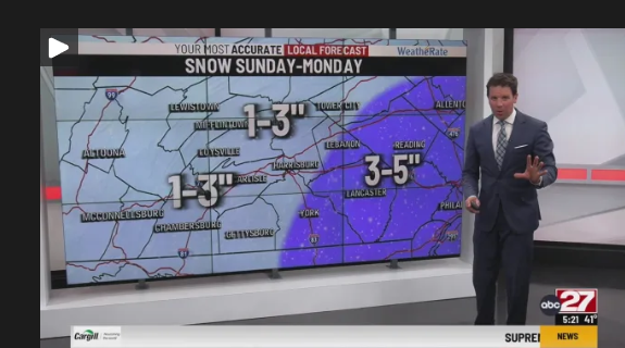
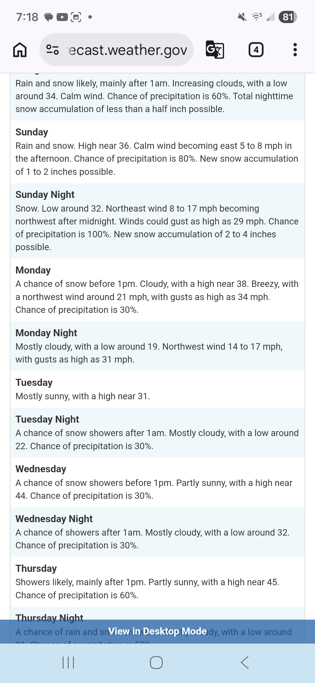
SundaySnow before 10am, then snow, possibly mixed with rain between 10am and 4pm, then snow after 4pm. High near 36. Calm wind becoming east around 6 mph in the afternoon. Chance of precipitation is 100%. New snow accumulation of less than one inch possible.Sunday NightSnow. Low around 29. Light and variable wind becoming north 5 to 9 mph in the evening. Winds could gust as high as 21 mph. Chance of precipitation is 100%. New snow accumulation of 2 to 4 inches possible.Thats my NWS forecast.
-
1
-
-
-
15 minutes ago, Ruin said:
god pls let this be so wrong and let us get like 8 inches this guy is always so smug about low balling snow
Yea 27 is really downplaying this coming event.
-
30 minutes ago, canderson said:
It is crazy foggy
Whiteout fog.
-
57 minutes ago, Voyager said:
Is there any chance things move even more west yet before Sunday? I hate when a big dog comes and Philly to NYC steals the thunder and gets crushed while we're out here looking at gradients and lesser amounts.
If we're going to get this, I want to be in the 20" plus area.
I hope we all the the most accumulation possible...then we can all move on to Spring
-
1
-
-
URGENT - WINTER WEATHER MESSAGE
National Weather Service State College PA
140 PM EST Fri Feb 20 2026
PAZ057>059-064>066-211145-
/O.NEW.KCTP.WS.A.0004.260222T1000Z-260223T1800Z/
Dauphin-Schuylkill-Lebanon-Adams-York-Lancaster-
Including the cities of Pottsville, Hershey, Harrisburg, York,
Lancaster, Lebanon, and Gettysburg
140 PM EST Fri Feb 20 2026
...WINTER STORM WATCH IN EFFECT FROM LATE SATURDAY NIGHT THROUGH
MONDAY AFTERNOON...
* WHAT...Heavy snow possible. Total snow accumulations between 4 and
6 inches possible.
* WHERE...A portion of central Pennsylvania.
* WHEN...From late Saturday night through Monday afternoon.
* IMPACTS...Travel could be very difficult. The hazardous conditions
could impact the Monday morning commute.
* ADDITIONAL DETAILS...There is still some uncertainty regarding the
track of this storm. Any westward shifts in the track may result
in higher snowfall amounts.
PRECAUTIONARY/PREPAREDNESS ACTIONS...
Monitor the latest forecasts for updates on this situation.
&&
-
1
-
-
After today and tomorrow the snow (wha'ts left) on the ground will be gone...except the piles of snow.
-
storm 2 days out and the US GFS continues to have an epic storm in places where the euro has next to nothing I have no changes on my idea of 6-12 locally 18 DC to Boston, which almost seems like a mid-ground. This model battle should be something GVT officials are looking at. If GFS misses, what good is it? Why spend the money it took to develop this model if it consistently is least accurate vs the major models, though it beats up on the Navy NoGaps and CFSV2 , which is like beating up on a division 2 school if you are Division 1I will show the method I use for numbers later today You might find it interesting. Will do Bos,NYC, DC, State College and ACY
-
2
-
-
So is it still early for a final outcome of this storm, were within about 50 or so hours of the storm?
-
-
From our good friend DT:
NEXT TIME SOME IDIOT ARGUES THE GFS HANDLES EAST COAST SNOWSTORMS WELL...
TIME TO CANCEL THE GFS.....
33 INCHES OF SNOW DC ? Yeah its broken
every Single run of the operational GFS for the past 3 days has showed a massive historic record shattering blizzard for some portion of the Middle Atlantic...
now even the GFS AI is saying "WTF op-GFS !? "
The 6z and 12z GFS ensembles are waaaaaay east
The problem is that the operational GFS goes Bonkers with the 500mb LOW. It is over developing the 500 LOW amplification and it grabs the surface LOW and pulls a NW to just east of Wallops Island on the lower Virginia Eastern shore. Then every run of op- GFS stalls the LOW for 24 hours producing this incredibly heavy snow area from a monster rapidly intensifying Coastal nor'easter.
This is nonsense.
There is a better chance of monkeys flying out of my ass on Sunday night or Monday morning then this solution as proposed by the operational GFS of a massive historic BLIZZARD of record shattering proportions in the Mid-Atlantic actually concurring
As I stated in the video there is an upstream kicker and all the other models see it except for the operational GFS.
When the GFS AI and GFS ensembles don't even support this kind of extreme solution then you know the operational GFS is just busted.
I figure it's about 12 hours before somebody starts blaming immigrants for fucking with the model.


Central PA Winter 25/26 Discussion and Obs
in Upstate New York/Pennsylvania
Posted
Heard the geese last night around 11pm sounds like they were headed north. So the signs of spring are starting to show.