

mahantango#1
-
Posts
4,256 -
Joined
-
Last visited
Content Type
Profiles
Blogs
Forums
American Weather
Media Demo
Store
Gallery
Posts posted by mahantango#1
-
-
Wxrisk.com updated their profile picture.
LOW MID 90s a good bet JUNE 22-28 east of the mountains
-
 1
1
-
-
6 hours ago, canderson said:
Big heat and humidity hit this weekend and look to last without a real end in sight.

-
 1
1
-
-
1.10 rain this weekend. 3.24 for the month so far. Please no more for at least a week.
-
looks like another gloomy day on tap.
-
1
-
-
3 minutes ago, Voyager said:
0.76" so far for this "event".
.57 here.
-
1
-
-
.09 rain overnight here. A cool 59 cloudy gloomy kind of day so far. Hopefully there will be some improvement throughout the day. And keep that heavier rain away from me. I rototilled the garden yesterday. I hilled up my potatoes yesterday. That ground was heavy to move up against the potato plants. They should have been hilled up several weeks ago. But the constant rain and water laying in the garden made it impossible to do.
-
1
-
-
-
-
Flood Watch National Weather Service State College PA 241 AM EDT Sat Jun 14 2025 PAZ010>012-017>019-045-046-049>053-142000- /O.NEW.KCTP.FA.A.0012.250614T0641Z-250614T2000Z/ /00000.0.ER.000000T0000Z.000000T0000Z.000000T0000Z.OO/ Elk-Cameron-Northern Clinton-Clearfield-Northern Centre-Southern Centre-Southern Clinton-Southern Lycoming-Union-Snyder-Montour- Northumberland-Columbia- Including the cities of Sunbury, Renovo, Ridgway, St. Marys, DuBois, Lewisburg, Bloomsburg, Philipsburg, Williamsport, Lock Haven, Clearfield, Berwick, Selinsgrove, Shamokin, Danville, State College, and Emporium 241 AM EDT Sat Jun 14 2025 ...FLOOD WATCH IN EFFECT THROUGH THIS AFTERNOON... * WHAT...Flash flooding caused by excessive rainfall is possible. * WHERE...A portion of central Pennsylvania, including the following areas, Cameron, Clearfield, Columbia, Elk, Montour, Northern Centre, Northern Clinton, Northumberland, Snyder, Southern Centre, Southern Clinton, Southern Lycoming and Union. * WHEN...Through this afternoon. * IMPACTS...Excessive runoff may result in flooding of rivers, creeks, streams, and other low-lying and flood-prone locations. Flooding may occur in poor drainage and urban areas. * ADDITIONAL DETAILS... - A several hour period of moderate to heavy rainfall and possible embedded thunderstorms this morning could produce widespread rainfall amounts of 1 to 2 inches in the Watch area with local amounts exceeding 3 inches. Rainfall rates of 1 to 2 inches per hour could produce flash flooding. - http://www.weather.gov/safety/flood PRECAUTIONARY/PREPAREDNESS ACTIONS... You should monitor later forecasts and be prepared to take action should Flash Flood Warnings be issued.-
1
-
-
1 minute ago, Voyager said:
Of course I'm not a college trained meteorologist, but I have a feeling this pattern is going to keep going for most, if not, the entire summer.
You could be very well right on that.
-
-
-
Hazardous Weather Outlook...UPDATED
National Weather Service State College PA
430 AM EDT Fri Jun 13 2025

PAZ017>019-024>028-033>036-056-057-059-063>066-140830-
Clearfield-Northern Centre-Southern Centre-Cambria-Blair-Huntingdon-
Mifflin-Juniata-Somerset-Bedford-Fulton-Franklin-Perry-Dauphin-
Lebanon-Cumberland-Adams-York-Lancaster-
430 AM EDT Fri Jun 13 2025

This Hazardous Weather Outlook is for central Pennsylvania.

.DAY ONE...Today and tonight.

Showers will become numerous later this afternoon and
tonight along with isolated thunderstorms, that will
bring up to one inch of rain in some places by sunrise
Saturday. The main impact of the rain later today and
tonight will be to prime the ground for potential
flooding from additional showers and storms this weekend
into early next week.

.DAYS TWO THROUGH SEVEN...Saturday through Thursday.

Several rounds of locally heavy rainfall could result
in an increasing threat for short duration flooding
Saturday and Sunday.

.SPOTTER INFORMATION STATEMENT...

Spotters are encouraged to report significant hazardous weather.
-
1
-
-
-
4 minutes ago, Voyager said:
Every global model suite is showing close to 2 inches of qpf through next Friday.
Was talking to the farmer yesterday that farms our land. He said they are behind on planting. He said they couldn't plant our neighbors 1.5 acre section because of it being too wet. They are a month behind on planting our farm. Now our farm was the last to be planted. He also said they might have to replant soybeans that were planted this year in cornfields from last year, I asked why, he said slugs eat the seed because it was so wet and cold. The perfect weather for slugs to thrive.
-
-
-
Short on info:

-
Hazardous Weather Outlook
National Weather Service State College PA
439 AM EDT Thu Jun 12 2025

PAZ004>006-010>012-017>019-024>028-033>037-041-042-045-046-049>053-
056>059-063>066-130845-
Warren-McKean-Potter-Elk-Cameron-Northern Clinton-Clearfield-
Northern Centre-Southern Centre-Cambria-Blair-Huntingdon-Mifflin-
Juniata-Somerset-Bedford-Fulton-Franklin-Tioga-Northern Lycoming-
Sullivan-Southern Clinton-Southern Lycoming-Union-Snyder-Montour-
Northumberland-Columbia-Perry-Dauphin-Schuylkill-Lebanon-Cumberland-
Adams-York-Lancaster-
439 AM EDT Thu Jun 12 2025

This Hazardous Weather Outlook is for central Pennsylvania.

.DAY ONE...Today and tonight.

A few strong thunderstorms containing small hail and gusty
winds will likely form across the Northern Mountains of the
state this afternoon and drift slowly south across the Central
Mountains, Middle Susquehanna Valley and Western Poconos
late today and this evening.

.DAYS TWO THROUGH SEVEN...Friday through Wednesday.

Several rounds of slow-moving showers and thunderstorms
with locally heavy rainfall will occur Friday night through
Sunday and could result in an increasing threat for flash
flooding of small streams, creeks and poor drainage areas.
The greatest risk for flash flooding will likely be late
Saturday and Sunday. The southern portion of the state and
areas of complex terrain will be especially vulnerable given
enhanced rapid runoff with heavy rainfall.
-
1 hour ago, Voyager said:
We need it. Getting pretty dry in my backyard...
NOT.
Yea the mud is a tinge dry. I walked down to the garden. There is a little water laying in a few spots. I walked in the garden and I started to sink in the ground. It will be at least tomorrow till (I hope) I can get in there hopefully to rototill.
-
more rain.

-
 1
1
-
-
-
My garden has water sitting in it again.
-
25 minutes ago, Voyager said:
0z Euro clown map through 180 hours. It has the highest numbers of all the globals, but still....
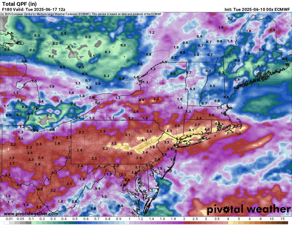
More doom and gloom. Man I'm hoping this is not a setup for a repeat of 1972.


Central PA Summer 2025
in Upstate New York/Pennsylvania
Posted
picked up .28 rain this morning.