

Met1985
-
Posts
16,909 -
Joined
-
Last visited
Content Type
Profiles
Blogs
Forums
American Weather
Media Demo
Store
Gallery
Everything posted by Met1985
-

2023-2024 Fall/Winter Mountain Thread
Met1985 replied to The Alchemist's topic in Southeastern States
There's some moisture actually forming ahead of the main slug coming through Tennessee that wasn't modeled . -
2023-2024 Fall/Winter Mountain Thread
Met1985 replied to The Alchemist's topic in Southeastern States
Fell off a cliff for a few minutes here with this line of showers. Went from 48 to 42 in about 8 minutes. Might have heard little hail but I didn't hop outside to check. Yeah down to 40 now. It is dropping like a rock. -
2023-2024 Fall/Winter Mountain Thread
Met1985 replied to The Alchemist's topic in Southeastern States
Temps dropping now. Down to 44. -
If it makes you feel any better the NE is having a rough winter also. A lot of them just went from a winter storm 8-12 inches to literally nothing in 24 hours....
-
2023-2024 Fall/Winter Mountain Thread
Met1985 replied to The Alchemist's topic in Southeastern States
Severe Thunderstorm Warning for... Northern Madison County in western North Carolina... Mitchell County in western North Carolina... Northern Yancey County in western North Carolina... * Until 1045 PM EST. * At 940 PM EST, severe thunderstorms were located along a line extending from 16 miles southwest of Kingsport to 9 miles southeast of Greeneville to 12 miles west of Marshall, moving east at 45 mph. HAZARD...60 mph wind gusts. SOURCE...Radar indicated. IMPACT...Expect damage to trees and power lines. * Locations impacted include... Burnsville, Hot Springs, Bakersville, Buladean, Bandana, Ramseytown, Green Mountain, Swiss, Faust, and Allenstand. -
2023-2024 Fall/Winter Mountain Thread
Met1985 replied to The Alchemist's topic in Southeastern States
Some of tonight's short range models. Sent from my SM-G998U using Tapatalk.thumb.jpg.41e5e2129f89324c52e0d2beeb381d80.jpg)
.thumb.jpg.1dd367f3317f63d57db860128ef55bcc.jpg)
.thumb.jpg.d299e4c9fd536393edc8d5865ef6b024.jpg)
-
Yes we visited Charleston a few weeks ago and we had lows in the 40s and highs in the 50s and it was perfect for walking around the city. We are going to get down to Savanah soon. You'll have to tell me all the good places to eat. I've heard Forsyth park is amazing.
-
2023-2024 Fall/Winter Mountain Thread
Met1985 replied to The Alchemist's topic in Southeastern States
Yeah with the low staying further south this has helped us out a lot more with some flow snow. -
2023-2024 Fall/Winter Mountain Thread
Met1985 replied to The Alchemist's topic in Southeastern States
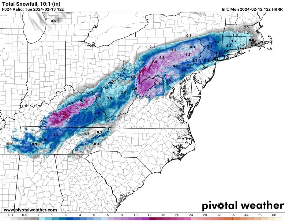
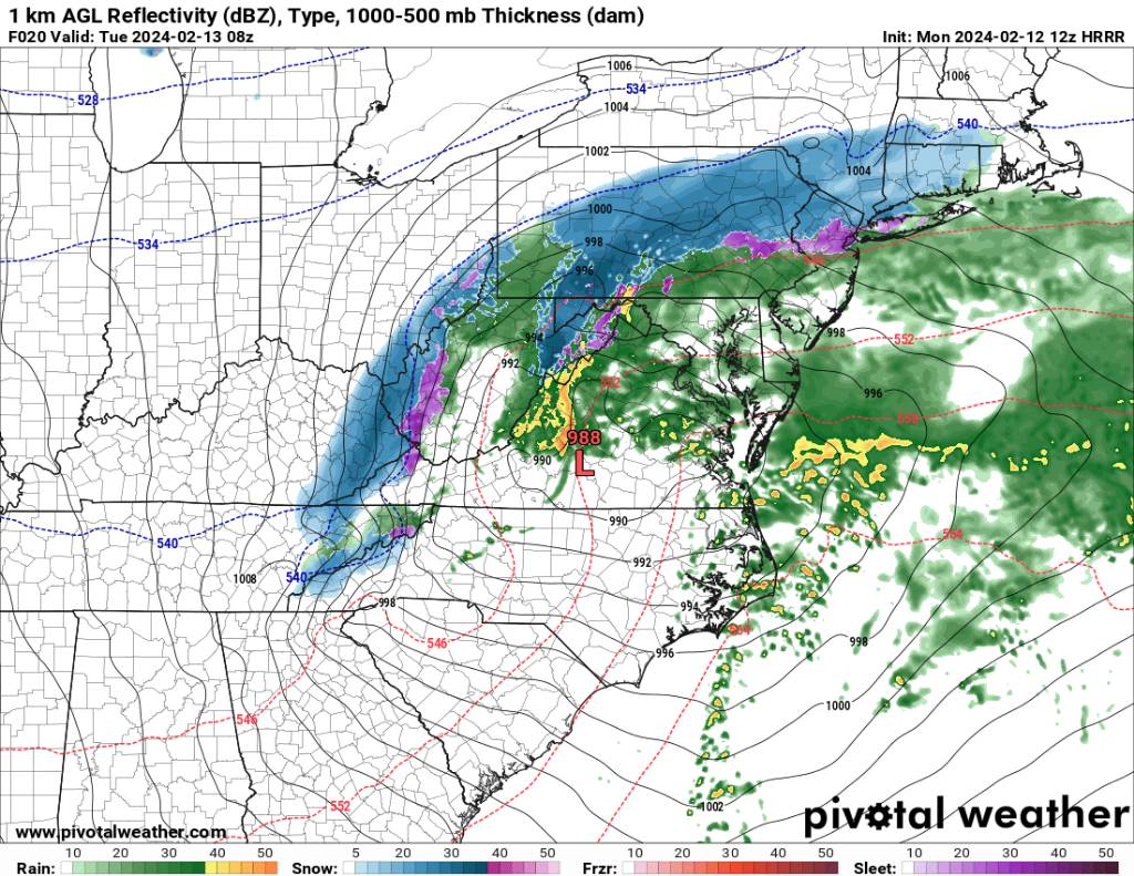
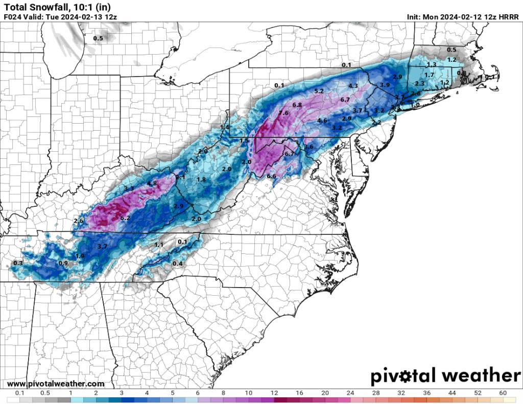
HRRR looking decent with some last minute shifts south. Sent from my SM-G998U using Tapatalk
.thumb.jpg.256b4fd339a1b774782630211d75c778.jpg)
-
I hope Mexico enjoys that colder weather.
-
Euro a lot colder than previous run.
-
2023-2024 Fall/Winter Mountain Thread
Met1985 replied to The Alchemist's topic in Southeastern States
Flooding concerns starting tonight for the southern mountains. -
That figures. We just cannot get out of the state of LA Nina.
-
Yeah that's all we need. We don't need bone chilling cold because things will be suppressed too far south.
-
Also I'll add that yes again the damn cold is in Europe. They have had a heck of a winter out there. From unusual blizzards to extreme boughts of cold.
-
That would work for several.
-
This winter has been all about scoring whenever we have favorable weather. That really goes for all around the country and not just us. From the NE to the Midwest, to the mountain west. It's just been that kind of winter for the entire country.
-
That would at least get a lof of people some flakes. Literally from the mountains to the ocean. In the Euro we trust.
-
The only reason I asked is because it's a hot topic and can go down a ton of different rabbit holes. I'm not agreeing or disagreeing at all. Just trying to stay on topic. If yall want to challenge me then please do.
-
If yall want to argue climate change then make a thread. Please keep it out of the mid range thread please.
-
The MJO hasn't and isn't the only driver this winter and the lead plots have been horrible this winter. There are MULTIPLE variables in the coming up pattern.
-
2023-2024 Fall/Winter Mountain Thread
Met1985 replied to The Alchemist's topic in Southeastern States
Yeah I think that's about all we can be. Just getting a new pattern set will help. I'm watching the jet screaming across the SW which is interesting. -
The cmc and it's ensembles look fine. Sent from my SM-G998U using Tapatalk
-
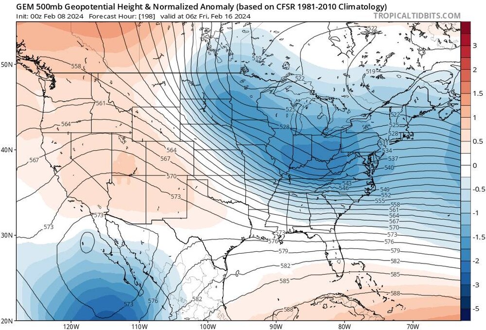
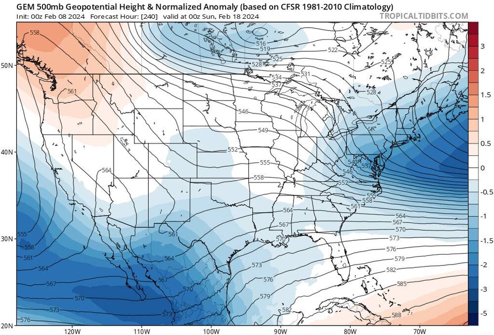
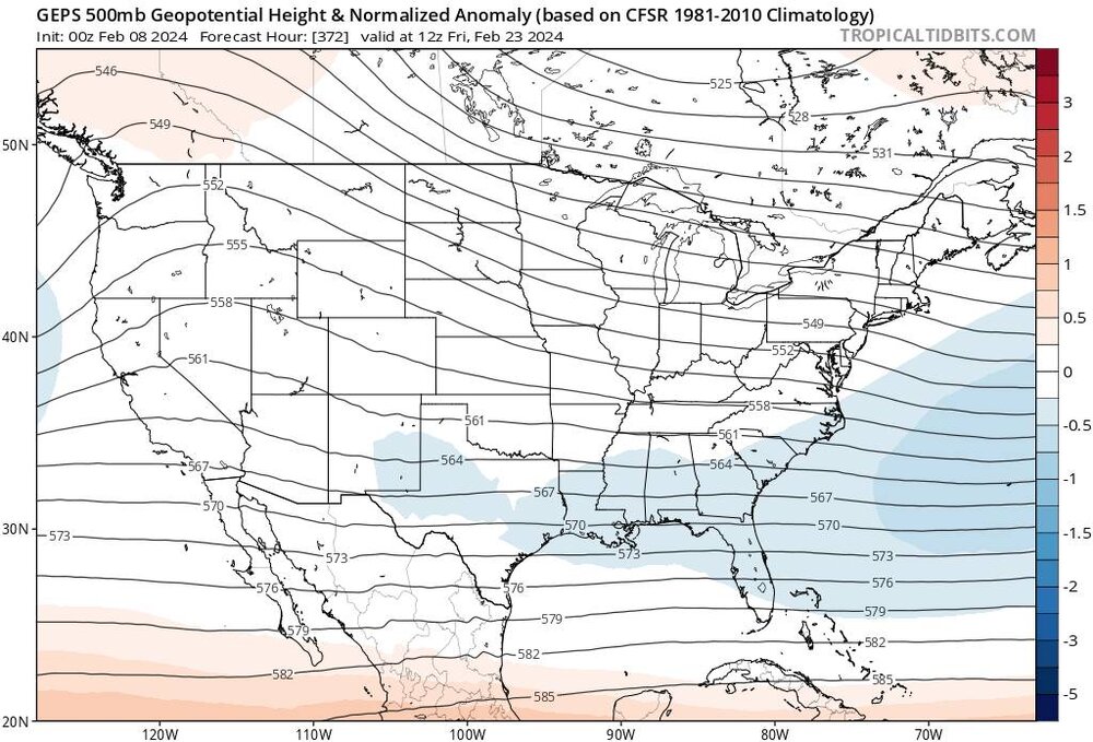
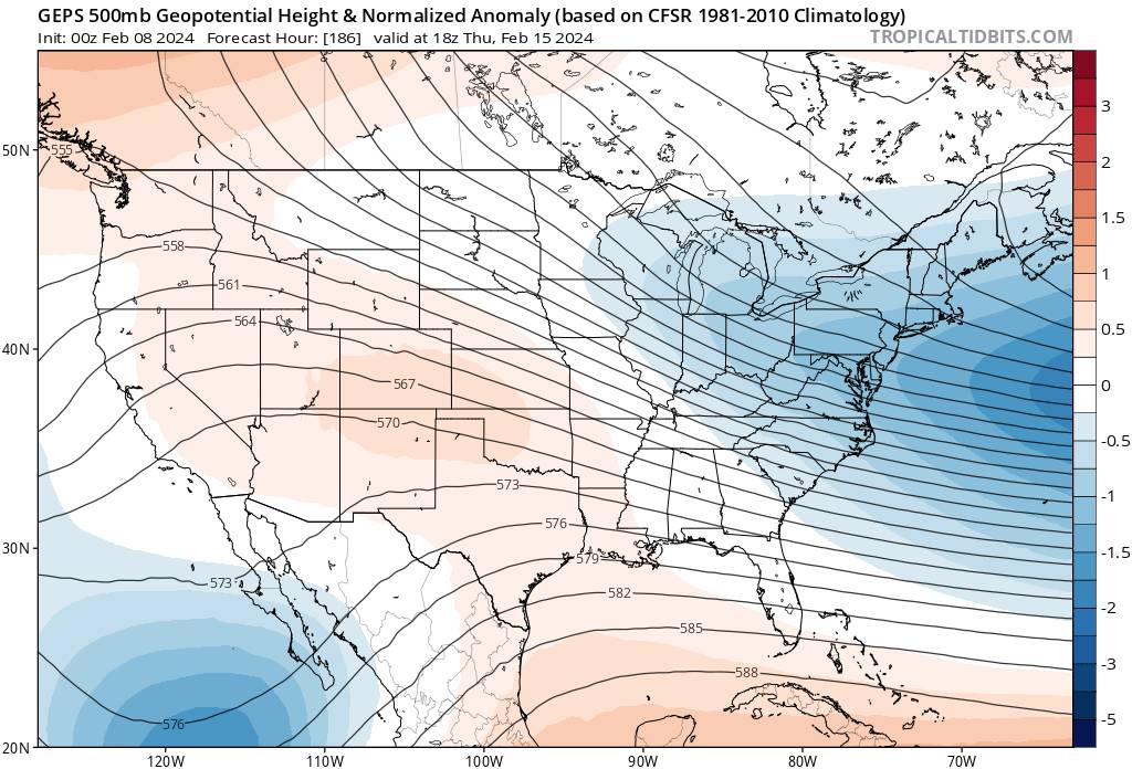
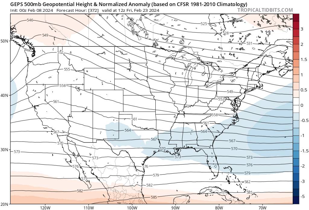
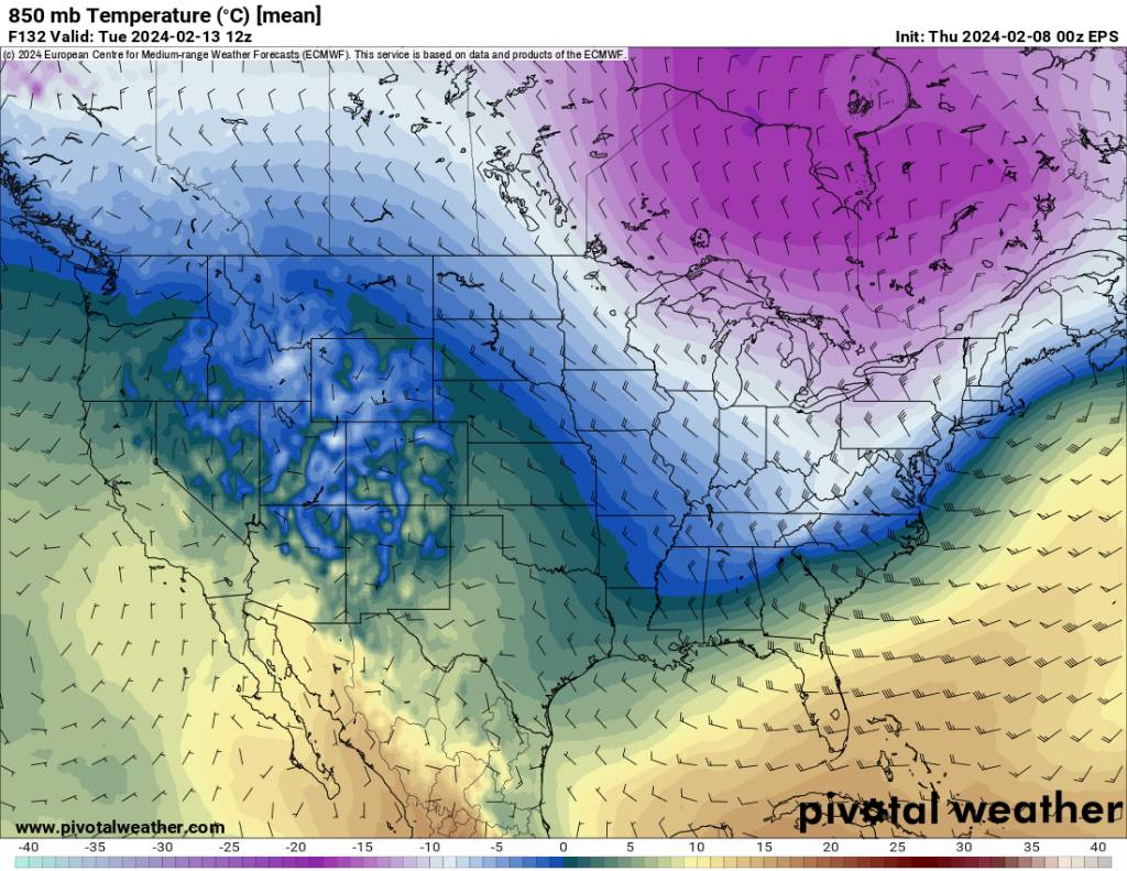
Overnight eps looks great in my opinion. GFS is out to lunch. Sent from my SM-G998U using Tapatalk

.thumb.jpg.41a850191ac9be896fb583d24dc0c11e.jpg)
.thumb.jpg.76d4dcd39fd9c9ed429add22b2e6ccc7.jpg)
-
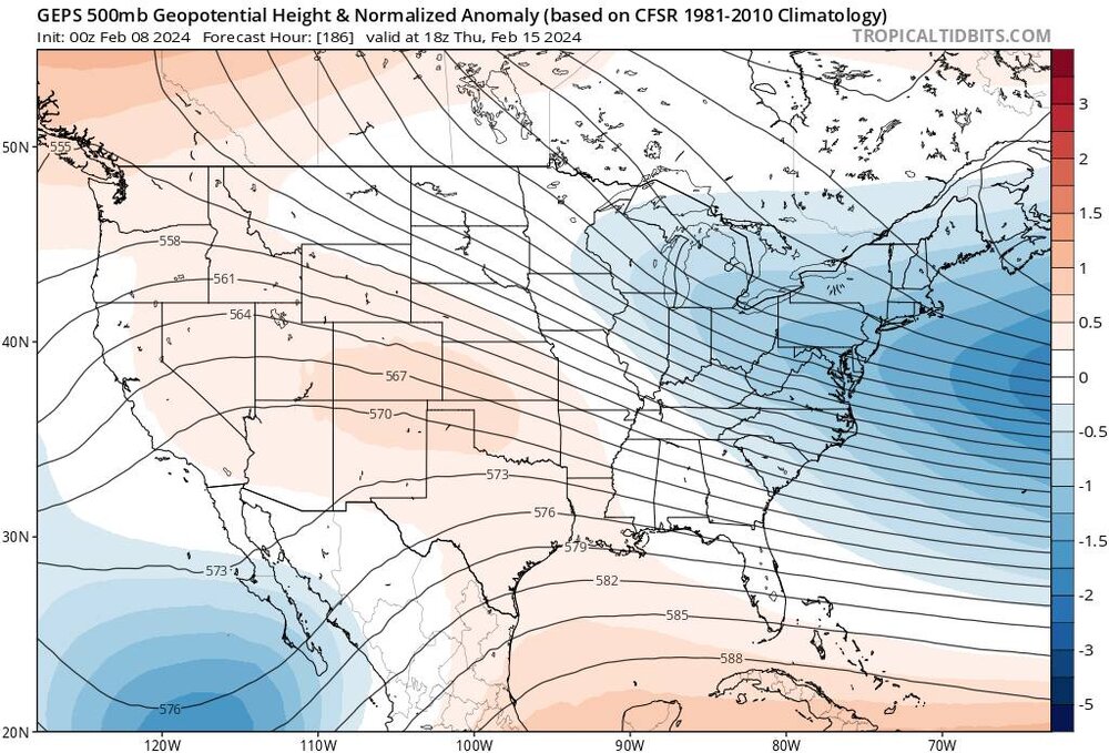
Seems like with each "update" the model just gets worse.


.jpg.7e560108368529a4e48535c37bd6a79f.jpg)
.jpg.654bd59861b7dc618c137c62776ea194.jpg)
.jpg.a9be6d120e2b9fdbe697b0ee618f5aeb.jpg)
.jpg.c4faac2507e122ec8e6739f8b1708aeb.jpg)


.jpg.9d372a49a53b4fb01733563d5d33c2ba.jpg)
.jpg.2a8ad2efc4dc56d06c40a84429ecec01.jpg)