

RogueWaves
-
Posts
2,256 -
Joined
-
Last visited
Content Type
Profiles
Blogs
Forums
American Weather
Media Demo
Store
Gallery
Posts posted by RogueWaves
-
-
16 minutes ago, cyclone77 said:
All of that variability makes me think this one will have surprises right up until the final 24hrs.
As we've seen many times this winter. Primarily when the thermals are mega-borderline. Some have still managed to produce a very narrow snowstorm zone, while others have just been cyber snow and little more.
-
Either way. I'll ride the 34F and rain as a slight majority. Let's call it 50/30/20% for RN/ZR/IP outcome from here. And no, we won't need skates since our ground is anything but frozen. The ISW wasn't about slippery roads at all, nor can this be if ZR actually plays out.
WPC does not see a snowstorm in our future
-
28 minutes ago, Stebo said:
There should be some wind but this isn't surrounded by a very strong high, so even if this ends up sub 980mb it won't be a big wind bag.
Thank you

This is 1/25 on 'roids...and going NW of us. Gonna b 34 Rainer for DTW again. Yay. But, we need the hydro
-
7 hours ago, Malacka11 said:
I'd rather get trolled than be a pessimist
I'd rather push the ignore button until it's inevitable. That's what I did with the S trending ice storm. It is a lot more fun "tracking" when you know it's real and not going poof like the Christmas Big Dog. I'm not into the pessimism posts. Gave that up after the Jan 25th storm held.
-
 2
2
-
-
Man, we sure are hungry for model abuse in here.
-
1
-
 2
2
-
-
5 hours ago, Powerball said:
Welp, in typical Detroit fashion, February always finds some way to pull through.
It won't be a 2nd snowless after all, as a shortwave moved through and apparently produced 1-3" overnight.
It missed "snowless" already, but now it's just another well BN month, like fractionally so.
-
25 minutes ago, SolidIcewx said:
It is pretty insane and knowing it could have been worse. Seeing poles snapped and trees 40 inches in diameter being brought down has been crazy to see too and I work with trees for a living lol. It shows tho we need to work on our electrical infrastructure
I thought that's what you're doing out there every day, lol
-
1
-
-
1 hour ago, michsnowfreak said:
1.4" of pure powder this morning. Quick hitter, didn't expect that much. Brings season total to date to 21.5". DTW also had 1.4", season to date 21.1".
This was our 6th shovelable snow of the season
Nov 19- 1.8"
Dec 23- 2.4"
Dec 25- 2.4"
Jan 22- 3.7"
Jan 25- 6.2"
Feb 25- 1.4"Then another 4" total of non shovelable snows.
Here are some ice storm casualties covered in snow.


There's your "more winter". Getting our late March inchers a month early. Tbh, the ice storm was my final interest of the season. Moving on from the cold season so when I opened the door to all white this morning not only was it a small surprise but a bit of a let-down lol, even tho it's mostly gone. Looking for sun and decent conditions going into March. Prolly go the other way and get a "reverse spring" as has been the norm in this Tri-Nina.
-
1
-
-
On 2/23/2023 at 10:55 PM, michsnowfreak said:
What's funny is that while this was undoubtedly a bad Feb, it doesn't feel AS bad as the snowfall number shows since the first week had snowcover and now the ice storm. Likewise, the first 3 weeks if January were so torturous, when the month ended it was like, wow how did we get a foot of snow in that sucky January?
Not a fan of ice, but this storm actually elevates the winter grade in my book.
-
2
-
-
3 hours ago, michsnowfreak said:
While we've certainly had some ice storms since then, the news is calling this the worst widespread ice storm in Southeast Michigan in 50 years. The ice has now melted but there's still tons of clean up to do.
March 1976 was the epic all-timer with 2+ inches of ice centered along the M-46/Saginaw corridor. I skated down the street in my neighborhood. Presuming they are referring to that one not quite 50 years ago. It was bad as in Genesee Cnty, but not sure about Detroit Metro.
-
 1
1
-
-
19 minutes ago, Harry Perry said:
Standing outside at the moment just listening to the crackling and crashing of tree branches in the distance. Power flashes look like lightning every few minutes. Several without power, half of my block is out but somehow managed at least for the time being to keep power at my place. Have approximately .50” of ice on everything. Tomorrow morning will make for some awesome pictures. Still raining here at 31°. Can’t imagine much more than maybe another .05” if that before this wraps up.
Jackson and Hillsdale got absolutely clobbered. Interested to hear what they ended up with total.
Glad it's not worse for you. When I saw GRR's graphic saying up to 3/4" ice and "as bad as 2013" I figured someone in that zone would be in trouble. A lot of trees in your area. So far, I have branches sagging, but haven't heard any breaking. I may just barely escape damage by the slimmest of margins.
-
Just now, michsnowfreak said:
Lots of power outages, trees down, and transformers blown in Wyandotte but so far all is good here.
Glad to hear. So far, so good here as well.
-
1
-
-
13 minutes ago, Hoosier said:
I keep imagining if the icing was farther south to encompass more of the metro. Yikes.
I keep imagining if we had legit cold air and this was a snowstorm.
I so wanted to stay up there. Missed it by mere hours. APX getting raked
-
7 minutes ago, SolidIcewx said:
Welcome back to the metro

Thx. Missed my brown ground.
Thought temps would slowly RISE. Apparently that was too optimistic.
For DTW...The peak freezing rain intensity (moderate to briefly
heavy) will persist through 04Z before it moves off to the east. Sfc
temps will hold around 32 degrees through the evening, then they
will actually drop a degree or two overnight. -
So..
000
FXUS63 KDTX 222327
AFDDTX
Area Forecast Discussion
National Weather Service Detroit/Pontiac MI
627 PM EST Wed Feb 22 2023
.UPDATE...
Reports of a tenth to near a quarter inch across Lenawee and Wayne
Counties has prompted an upgrade to an ice storm warning for
Lenawee/Monroe/Wayne Counties. Locals near Lake Erie in Monroe County
will likely have limited icing, however farther inland (particularly
near Petersburg, Dundee and Milan) icing to a quarter inch is
expected.
The convective burst which rolled across the area earlier and
produced a few elevated thunderstorms proved very efficient at icing
per spotter reports. Given upstream radar and with the loss of
daytime heating, icing on trees and power lines should prove very
efficient through the rest of the evening.
&& -
Coming back into the Metro from the west. Ofc driving in traffic but N side of Ann Arbor may have been pushing 0.4-0.5 accretion. Nervously drove under a large tree that was leaning way over my lane. Looked primed to plunge at any moment. Drooping power lines and some shorter trees with branches touching the ground. Stopped for a couple groceries and power went out for about a minute. Got to see my first ICE STORM WARNING on the MDOT signs. That was cool. Just missing Snow Squall Warning for the complete set of winter headlines. As Hoosier says, some region will be "just right" for the maximum combined effects. Hopefully not too large an area here in SMI.
-
Widespread 3-6+ where I am in NMI. Classic winter morning. Car thermo at 23F. No melting. What's that?
-
3 hours ago, HillsdaleMIWeather said:
IWX and DTX both state they may need to upgrade their WWA areas later
DTX:
With the current outgoing forecast out of the way will offer to
insight in a potential deviation point as this gets into the latest
model trends and ramifications we`re watching. Hi-res runs this past
evening and tonight from the HRRR/RAP to NAM Nest (and to a lesser
magnitude the NAM12) are having a harder time lifting the frontal
slope into the area resulting into a shallower elevated warm nose
over the I-69/M-59 corridors, increasing sleet probabilities. If
this scenario pans outs, there would be a southward shift in primary
freezing rain axis towards the I-96/94 corridors... which as a
sidenote would be more in line with what the GFS and Canadian-NH
have been advertising. In addition, this would limit the chances to
switch to all rain over the far southern CWA instead remaining
wintry mix/freezing rain and increasing icing... which could warrant
a need for an upgrade of some or all of the advisory counties to an
ice storm warning. Areas of additional concern/uncertainties are the
effect of the still open waters of Lake Huron sitting firmly in the
mid to upper 30s, degree of latent heat release from higher rainfall
rates (or conversely any wet bulb cooling given dewpoints in the
20s), and the effect on ice accretion efficiency given the moderate
precip rates. Unfortunately these three points remain fairly
nebulous and really won`t be known until the event actually begins.
So basically, they won't know until it is already a done deal. Perfect for that office. They can then bump headlines.
-
22/0z RGEM pounding Metro Detroit with snow tomorrow noon

Then proceeds to destroy with ZR
-
6 minutes ago, HillsdaleMIWeather said:
Local news stations are now calling for Hillsdale to get 0.25 to 0.5, a lot more than the current IWX forecast
I think they're right. The only good thing is temps are expected to get way above freezing Thursday. Doesn't stop the damage during the event, but it's better than just plunging into the deep freeze as so often happens.
-
APX snippet. Wish I could just phone work and stay up here, lol.
If we do manage to get the stronger gusts as guidance suggests...in
combination with the potential for intense snowfall Wednesday
night...not out of the question visibilities could drop to 1/4 mi or
less...which would put us pretty close to blizzard conditions at
times overnight. Additional concern with the winds is that if we are
able to get into the ice at all...suspect winds will be efficient at
helping ice accumulate on surfaces.
-
1
-
-
Just now, beavis1729 said:
Dallas was near 90 today, and it’s currently -18 in Bottineau ND. Not bad.
Which one?
-
2
-
-
2 minutes ago, Powerball said:
Maybe January 1978?
That's the closest true mega-storm I can think of. Would need some confirmation on west half of Yoopland. I know the eastern UP got under headlines for sure.
-
1 minute ago, michsnowfreak said:
Technically lol Dec 22, 2022
Our great winter of 22-23. Highly regarded for mega-storms top to bottom!
-
1
-
 1
1
-


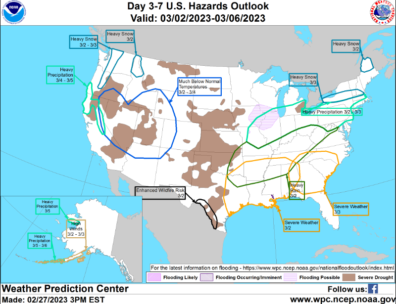
March 3-4 Potential Winter Storm
in Lakes/Ohio Valley
Posted
maybe