

RogueWaves
-
Posts
2,256 -
Joined
-
Last visited
Content Type
Profiles
Blogs
Forums
American Weather
Media Demo
Store
Gallery
Posts posted by RogueWaves
-
-
14 minutes ago, michsnowfreak said:
Pretty pic but I actually was mad to see the sun today. I don't care that it's been cloudy 95% of the time this Winter or that more snow is on the way, I just can't stand to see sun melting snow lol.
At least it's not 50F like the day b4 the storms last winter, but yeah, the one day we get a "warm sun" go figure!
-
..aaand we've lost the ORD crew
-
 4
4
-
-
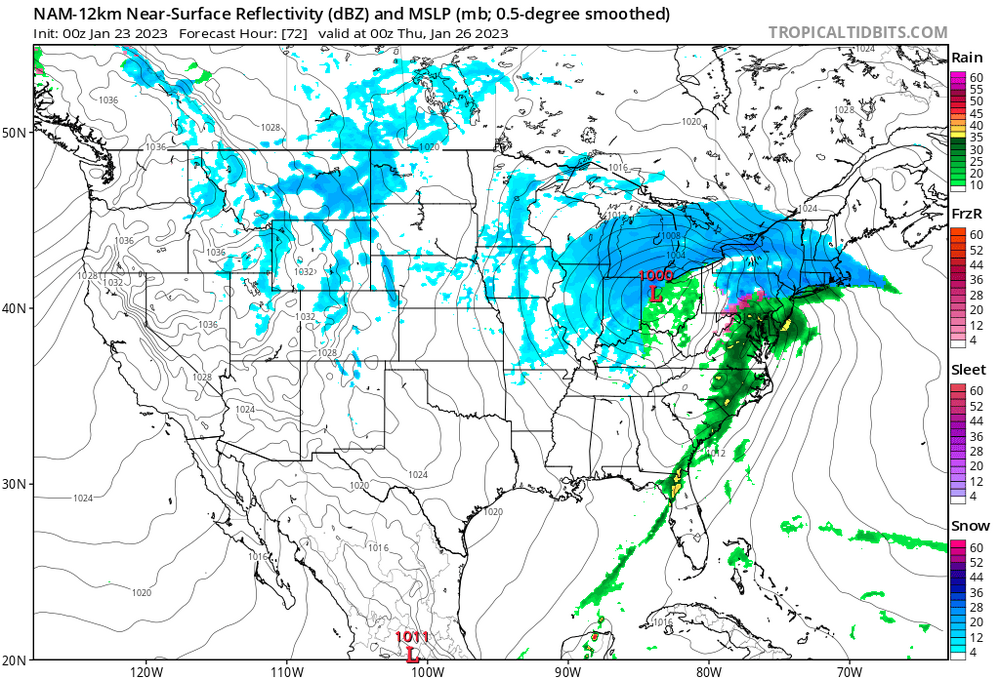
0z NAM reflecting CLE's mention of the SLP "drifting east" as it occludes and x-fers. Lingers snows here all night
-
 1
1
-
-
15 minutes ago, Powerball said:
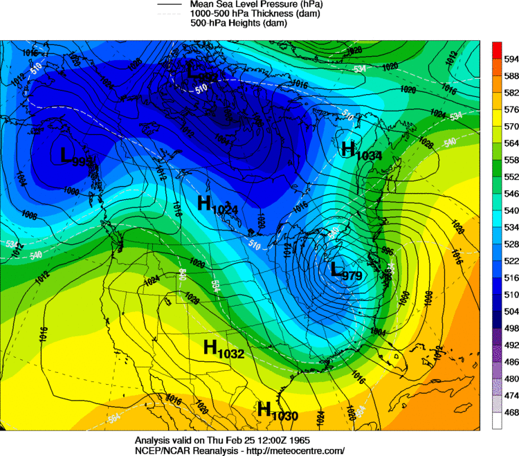
This is my first time hearing about that 1965 storm, lol.
1974 was by far the more exciting storm based on everything I've heard/read.
Very dynamic and cold storm w/high winds
-
WPC seems to be going with the NAM camp

-
59 minutes ago, AWMT30 said:
HRRR is solid for the Detroit area and points south!
Out to what hour? Only goes to h18 on TT
-
2 minutes ago, Powerball said:
This really could have been a special storm with just a bit less confluence over Ontario/Quebec.
Oh well...
For here, the old saying that it's always something applies. Hard-hitter storms for Detroit Metro proper are a rare breed. Feb '65, Jan '92 are the only two that come to mind where they were free to shoot north in Canada without the dreaded dry slot or WTOD mode so common. Don't remember if 2/5/11 kept going north in Canada?
-
21 minutes ago, OHweather said:
ILN largely did that due to concerns that snowing an inch an hour during the commute in Cincinnati and Dayton would be a mess as opposed to any confidence in reaching warning criteria snow totals. We'll see if it pays off, as if it trends north the thump of snow would occur north of Cincinnati. Not everyone would've issued that watch but I appreciate the reasoning. I didn't have the confidence to go with a wider watch for "impacts" into our CWA today, though some models certainly suggest it's not impossible that northern OH gets good snow even east of the low track. Front end thumps can be sneaky when the forcing is robust. I'm just excited that it looks to snow half decently for a wide area, especially on the front end.
I just finished reading their updates. Agree with the impact-based reasoning/decision. I remember some awesome front-enders years ago and it is a traffic nightmare that a simple last-minute WWA headline or SWS doesn't do justice.
-
1
-
-
23 minutes ago, WestMichigan said:
18Z GFS says SW OH is in the game.
Front-end thump snow like we used to get a lot of in late 80's
-
LOL, Watches expanded S in Ohio. Which office is winning that battle??
-
15 minutes ago, Hoosier said:
It's odd when I'm the more tempered one.

At this point, just don't see a compelling case for an advisory for at least the northwest half and more like 2/3 of the LOT cwa. But we'll see if things can trend better across the guidance suite.
Still lots (LOT's) of time for Chi-town Peeps
-
Just now, Stevo6899 said:
Dtx never fails to find the dry slot, and nam been saying it's maybe coming.
Euro been counter-balancing the GFS/NAM's more NW trends. Meet ya in the middle
-
1
-
-
12 minutes ago, Chicago916 said:
Unless the NAM keeps trending north and is correct and the Metro gets 6+ inches of lake enhanced snow that sticks due to higher rates (if only)
We will know when it turns the corner
-
6 minutes ago, Hoosier said:
Wonder if Michigan may be able to do slightly better with ratios. Progged to be just a touch cooler in most of that state with the exception of the southeast corner. So Josh may struggle a bit more with ratios than the areas nw of there.
Would love to stay at 32 or below, but even a couple hrs of 33F wouldn't be a total slop-fest. 2-24-16 comes to mind wrt the <10:1 storms (think RC mentioned it). That was a mushy mess but still plow-worthy and piles were made. I'll be satisfied with that outcome. Anything breaks better for us, all the better.
-
12 hours ago, michsnowfreak said:
To be fair even the models had the heaviest snow in the South burbs. But I think we all exceeded expectations with this one.
They did. Just meant that systems have favored your region with higher totals on any given event. Can't imagine it was/will always be that way throughout time, lol
-
@michsnowfreak Downriver/DTW wins again. Some day this may switch around, but for at least two seasons it's undeniable
-
1
-
-
5 minutes ago, madwx said:
0Z GFS is just a tick NW of 18Z but otherwise almost identical
Didn't look side-by-side but I think it was deeper as well?
-
Definitely N @ h72 (snow lingers here until 12z Thur morning)
-
Just now, Baum said:
once again underscores the uselessness of models. Euro has been consistent for nearly the last 4 days on this and as we get closer to event it comes in with a different solution. And this run affects far more than Chicago.
Punting this to Ohio??
-
1
-
-
48 minutes ago, Hoosier said:
Oof
18z GFS was the best more amped run yet. Figures Euro would say "nah"
-
24 minutes ago, cyclone77 said:
Brooms and leaf blowers sure getting a workout this winter. Shovels and snowblowers naso much.
Snowblowers maybe, but I never saw so many Municiple plows scraping what amounted to slush scraps here
-
34 minutes ago, mimillman said:
Long live futility. Long shall she reign
Heard the SREFs look better
-
2
-
-
Dbl Oof. Like IZZI said, could go either way from here. Dumpster fire torch winter = OH magnet. Anyone find that a bit strange??
-
13 minutes ago, AWMT30 said:
Personally I am leaning a solid 4-8" event. Although I don't think it will be enough to get a Watch Or a Warning.
You mean a classic SEMI Land of the 5-9" special? Prolly. If it hits hard enough tho, impacts could be more on the order of a larger event.
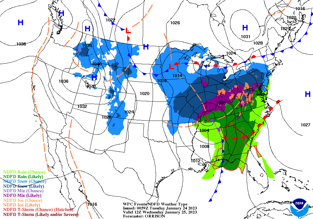

Midwest/Ohio Valley/Great Lakes Snow January 24-26
in Lakes/Ohio Valley
Posted
The Beavis of snow cover