

RogueWaves
-
Posts
2,256 -
Joined
-
Last visited
Content Type
Profiles
Blogs
Forums
American Weather
Media Demo
Store
Gallery
Posts posted by RogueWaves
-
-
33 minutes ago, Hoosier said:
I'm not sure it's warm ground per se. As mild as it's been, there's been hours/days with temps below freezing. I think the more likely culprit for the melting is the marginal temps along with just enough solar energy getting through.
Through to what, white covered ground that should be reflecting it's effects. Most certainly my melting from underneath is due to zero frozen turf leading into this. A couple days sprinkled amongst weeks of mostly >32F temps makes for a November style snow today.
-
1 hour ago, Sciascia said:
Chicago has had to become dependent on Feb-Apr for 95% of their seasonal totals recently. Best climo. Jealous?
Getting beat by SOH just sucks whatever the month, but especially in JAN. I think they're ahead of me for seasonal totals, lol
-
23 minutes ago, michsnowfreak said:
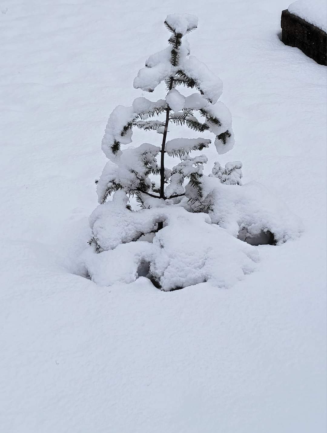
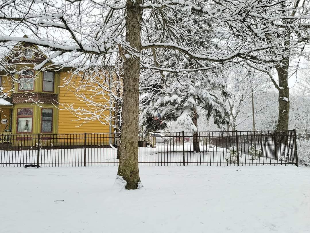
Very pleasantly surprised today. I honestly was expecting about 1" of slop instead got an absolutely postcard worthy 3.3" of snow. Sounds like around 2" fell to the North of Detroit but the East and South side had the most due to early banding.
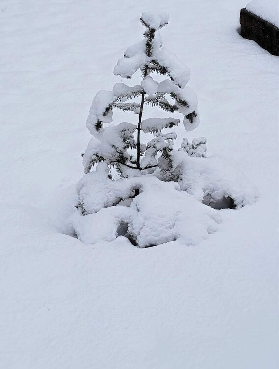


Thinking around 2" here. It "just" covered grass blades as the heavier stuff was ending, and it's been a melt-fest from the ground warmth since. Still a very picturesque and beautiful day with the trees covered. Like an early December system, but 6 wks tardy.
-
2 hours ago, Powerball said:
Honestly, the solution from a couple days ago that showed a major winter storm / blizzard up there still isn't entirely out of the realm, even with marginal temps.
The questions over the next 24-48 hours will be:
1. Whether the models are shearing the southern wave apart too fast given how much it digs and the strength of the jet streak, which has happened in the past (see 2/5/11 as an example).
2. Whether the models are overestimating the amount of confluence over Canada from today's lead wave.
The 12z GFS was definitely a small step in the right direction.
I remember that one. GHD-1 round-2 for Detroit metro is was a nice surprise hard smack-down. I think it was you that said the PV Bliz was a lame storm and the PV did all the work. Well, with like zero cold infusion, this will be the complete opposite. Can't possibly get both here, lol
-
4 hours ago, mimillman said:
Top 5 event of the year
Dayton with 7"
Chicago what has happened to you??
-
2 hours ago, Hoosier said:
My brain hurts
Not a Met obv. I meant that the flakes aloft don't generate at 7 or 8:1 where it's cold. The melting mush happens lower maybe even after landing in 33F conditions like this pm
-
4 minutes ago, Powerball said:
Not so much mixing issues as of late, but definitely rates for sure, since the vast majority of the "big" events have been low-amped (weak lift/instability) and northern-stream dominant (limitrd moisture).
That said, this storm definitely has potential given its gulf origins, the trough taking on a negative tilt and ULL possibly closing off.
I'm actually a fan of wetter snow, but a few degrees colder would've been nice, lol. Real-deal cold and this could've had the rare bliz potential for SEMI. Still looking ok for an impactful event. Anything to get plow piles around so when the inevitable melt-off occurs, it at least looks the season.
-
Just now, Powerball said:
Why for me? lol...
Thought it was you that always complained about weak rates and mix issues with SEMI storms.
-
 1
1
-
-
4 minutes ago, Hoosier said:
I'd caution about the 10:1 maps. This could be a case where those are overinflated. Marginal thermal profiles suggest some areas coming in under 10:1.
It'll be falling at 10:1 but what it becomes after hitting the ground is the issue.
-
@Powerball for you
Have been focusing on a
strong impulse that will eject out of the base of the upstream
trof and reach the area Wednesday. This will be a fast hitting
type of system with just snow (expected at this time). There is a
high likelihood of travel impacts Wednesday into early Thursday
-
5 hours ago, Stevo6899 said:
6zrgem also looks similar, strengthening as it heads NE. That's key here and the difference between an 8-12 and 3-6. If it weakens as it head NE, it'll transfer alot quicker
Could still "go south" ofc like many times for DTW, but trends to keep strengthening longer are coming together, which the 20.0z GEM had shown already Thur evening.
-
DTX "confidence higher than normal" due to consistency of GEFS/EPS at 500 mb
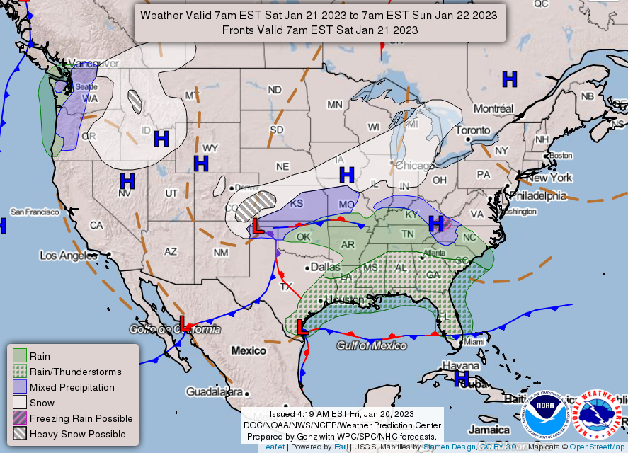
Attention during the coming days will be affixed on the mid latitude
cyclone/winter storm system that appears set to track through the
Lower Mississippi to Ohio River Valley Wednesday. Will not get into
details much since the storm system remains some 84 hours out,
rather will offer some commentary on the predictability of the
system. Definitely think its noteworthy to remark on the little to
no variability in the 500mb EOF patterns of the 22.12Z GEFS cluster
analysis. This lack of difference is between both eof1 and eof2 and
in the 500mb height difference signal at both Day3 and Day4. It is
also interesting, or maybe should not be surprising then, to not see
much d(prog)/dt variability in the 500mb vorticity field through
roughly the first 60 hours. Generally looking at a low variance,
strong closed off 500mb anomaly that digs clear through the Desert
SW into northern Mexico. Thereafter, variability does begin to
increase with the structure and timing of as many as 3 shortwave
centers that push into portions of western Canada, but do not see
much to suggest these vorticity anomalies will impact the phasing or
strengthening of the low pressure system as it tracks northeastward
out of the Lower Mississippi River Valley. Survey of 22.00Z EPS
member postage stamps is also suggestive of low solution variance.
The EPS members are showing a single mode characterized by heart of
cold side deformation/trowal impacting Lower Michigan (to varying
extents) with warm conveyor missing well to the south and east. What
will need to be sorted out is the quality and magnitude of moisture
that will advect meridionally into the system here locally rather
than just get shunted eastward. There are some indications in the
deterministic solutions that suggests convection and latent heating
over the Southeast United States could impact the low track. With
that stated, the forecasted structure and placement of the coupled
upper level jet into Ontario and Quebec supports a higher confidence
in a second low pressure center hanging close to Southeast Michigan
even if some east coast transfer wants to happen. Taking the lack of
solution variability in the EPS and GEFS in account, confidence is
higher than normal that the system will impact the area Wednesday
morning through Wednesday evening. The uncertainty is how far
northward the deformation snow will impact and what sort of snow
gradient will exist on the northern edge.
-
 1
1
-
-
44 minutes ago, Hoosier said:
The positive thing is that the GFS is pretty much by itself with its handling of the northern end of the precip shield. Hopefully you can at least pull an inch or two there.
SHE doesn't want "an inch or two"
-
 1
1
-
3
-
 1
1
-
-
Wow. I get it that it's been puke-worthy so far, but give this some time, like a few days before throwing towels (you ORD Peeps). Just need the GEM to hold serve and amp a bit at the last minute. All will be good
-
3 minutes ago, Stevo6899 said:
12z gem a little weaker with the wave but still solid run. Gfs considerably weaker, less impressive.
Every legit snowstorm west of us this winter has shown the same weaker outlook and then trended upwards closer in to game time. Be surprised if this throws that trend out a window.
-
46 minutes ago, Stevo6899 said:
Interesting that they think this thing has the potential to go nw of here which is possible if earlier phasing occurs.
Personally I think a little bit more N stream interaction will be back in play and shift the swath a bit NW more in line with the 21/0z GEM's portrayal. Can we get a 989 mb curving up just to our east like it shows (ala PV Bliz) Idk. One can hope.
9 minutes ago, nwohweather said:This type of storm track is typically a solid 6-10” for the region absolutely. Still the model spread won’t be clear until Monday night
Yep. Solid GRR advisory level system in play for SEMI/NWOH
-
1
-
-
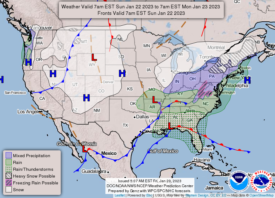
4 hours ago, Stevo6899 said:
Lock in the 0z Canadian. Perfect track and it strengthens it as it moves NE, while the gfs weakens it. Concerns me that the euro keeps it fairly weak. I guess it all depends on the phasing interaction which hopefully will be figured out by the models by mon.
Liking the GEM looks and apparently so is DTX. Overnight more bullish than I can remember this office being:
The quiet weather comes to an end Wednesday as the next
winter storm targets the region. Unlike many of the recent systems
that have curled north over the Midwest keeping us on the warm side
of the storm, models have held firm with a more southern track with
the surface and mid level lows tracking from Texas (Wed 00Z) up to
Ohio (Thurs 00Z) with southern MI solidly on the northwestern flank
of the system. Many ingredients are becoming favorable for an
accumulating snowfall over the area. The surface low will be
maturing near the area, favorable mid level deformation noses into
the southern Great Lakes, entrance region dynamics from an exiting
jet and exit region dynamics from rapidly approaching jet,
deformation region passing over the area, and a wealth of moisture
to name a few. Just how much snow will fall remains in question as
we are still 5 days out and a shift south would keep us more in a
light snow scenario, and north could push heaviest snow to the
north. For now we`ll highlight the potential for accumulating
snowfall Wednesday morning through the overnight. -
Not sure what to think about being under SN zone back to back days
-
4 minutes ago, michsnowfreak said:
A few interesting tidbits. Yesterday I got 1.30" of rain which was my largest precipitation event since February 17, 2022. That event was mostly frozen, so it was actually my single biggest all rain event since October 25, 2021.
Also, hard to believe in this Winter, but today's trace of snow was the 30th day of the season that DTW has had a trace or more of snow.
Never saw a hint of flakes. Is DTW down wind of a smoke stack or something? They seem like snow haven
-
1
-
-
DTX less descriptive than GRR by a long shot
although given the time
range there is reasonable agreement among the deterministic models.
A meaningful snow for SE MI becomes increasingly possible if this
track can hold going forward in upcoming forecasts.-
1
-
-
Today's CPC "cone" of expectations:
-
 1
1
-
-
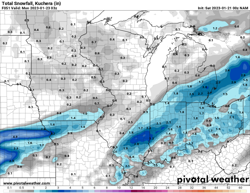
0z NAM came in hot for mby/SEMI with a 3" hit. Would be a fantastic way to start the return to winter
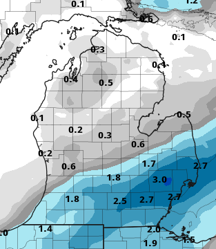
Wider view:
-
1
-
-
11 hours ago, dmc76 said:
It's Toledo.
KTOL needs even colder than KDTW! That cold blast in Feb '21 was their turn
-
5 hours ago, Jackstraw said:
You and me both know unless this maps 12 hours out its gonna be a kitchen sink Lucy pulls the football event for us lol. It is pretty to look at though

Models are tuned to present eye candy on marginal conditions - no joke
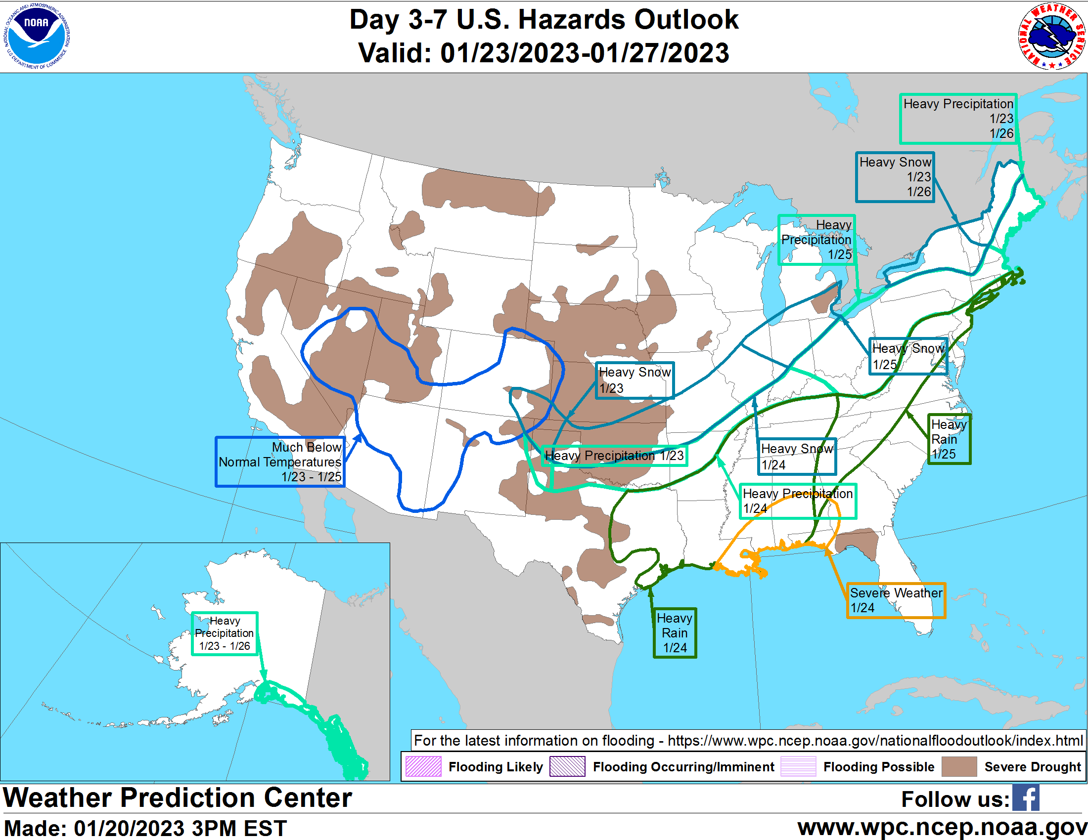

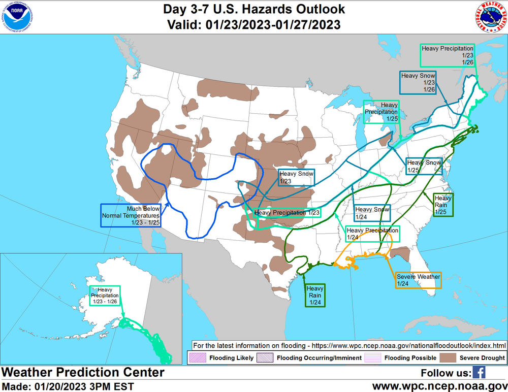
Midwest/Ohio Valley/Great Lakes Snow January 24-26
in Lakes/Ohio Valley
Posted
Can thank the lack of cold air for that
Saw that, lol'd. Downriver got 3" from today's "non-event"