

RogueWaves
-
Posts
2,256 -
Joined
-
Last visited
Content Type
Profiles
Blogs
Forums
American Weather
Media Demo
Store
Gallery
Posts posted by RogueWaves
-
-
6 hours ago, Frog Town said:
Wa, wa, wa, wait a minute....It's the 300 hr 6Z GFS....Bank it
After further review, I believe I was possessed by JB.

None too soon for the h300 fantasy snow maps. Thanksgivings in the early 00's featured several cold and or snowy ones iirc. Vividly recall 2005 when my fam met in Frankenmuth for a holiday dinner and it was like 5F WC's.
-
6 hours ago, Frog Town said:
Wa, wa, wa, wait a minute....It's the 300 hr 6Z GFS....Bank it
After further review, I believe I was possessed by JB.
Some day, peeps will be posting about "the ghost of JB". Like him or not, that's a legacy hard to deny.
-
2 hours ago, michsnowfreak said:
Weather stat guys like myself are so fortunate to have a wonderful website like Xmacis. On top of knowing Detroit's climate in and out, whenever I want to randomly run numbers for other cities I just have to go to xmacis. One day I was randomly just looking at regression lines for winter temperatures and it was absolutely clear that northeast winter temperatures have risen noticeably since records began while the Midwest was much, much more of a subtle rise and a few stations in the midwest and moreso in the northern plains have actually cooled. Subzero days today are far greater in SE Michigan than they were in the 1930s-50s, and far less than the 1970s-80s. The difference from mid 20th century to late 20th century was crazy.
The bottom line is if you're north of I-80 and you are just worried about snow, precip patterns and storm tracks will always be more important than temperature departures. Hell, last winter we had multiple snowstorms that caused damage, had blinding snow, and it was our 8th warmest winter on record. It is those of us who like the snow cover and enjoy the deep cold air who always want a colder winter.
I'm there. My recent string of bad winters has been brutal in this regard. Ofc, my preference is not just a few inches OTG, but substantial amounts. The quick to come, quick to go EC scenario might be fun when it happens but getting basically nada in between (over multiple seasons even) would be downright awful.
-
 1
1
-
-
3 hours ago, michsnowfreak said:
The Edmund Fitzgerald museum in Paradise, MI is a fascinating experience.
Winds gusted from 60-90mph in northern MI with 20 foot waves on Lake Superior. In Southern MI winds gusted 40-70mph.
At Detroit, the first 10 days of November 1975 were record smashing warm. To this day it stands as the warmest first 10 days of November by an impressive 3.0°. This storm brought much cooler temps (60s on the 10th, 50s 11th, 40s 12th) but no snow in SE MI.
And gun deer opener in NMI was a sunny and balmy affair. Felt more like October's bow season (which hadn't been born yet). 75-76 went on to be the first in a string of historic winters for both cold and snow in the Lower Lakes region. Especially known as a banner LES winter. But even places like my home region (KFNT) had their (then) snowiest January for instance. Only beat since by 2014. To note, that warm November of '75 did feature a cold bout around Thanksgiving and featured some snow systems that ended up making it a very snowy month in the end. A month of extreme contrasts, at least in my home region.
-
2
-
-
14 hours ago, Stevo6899 said:
Good thing I wasn't around for that. I'm all for wild temp swings as it may be the only setup/way we can get that historic big one...
Not sure which season you are speaking of there? As for the wild swings, see my other post and I agree. 1991-92 may fall into that camp as well. Iirc, it was a Nino that delivered an impressive "Detroit Special" in mid-January (some say it was a triple-phaser). 10-15" across the region in very dynamic fashion had much of the city at a virtual standstill. I was living in Traverse at the time and we'd had a blah season to that point so I wasn't too happy, lol.
-
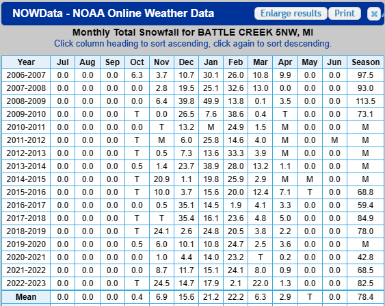
1 hour ago, michsnowfreak said:
Snowfall was around average at Detroit, but it was by far the most tame winter in a great stretch. I had 46.1" but 27" of that fell in Feb. I can remember the snow drought of Toronto and Northern New England that winter. I remember it was much colder that winter than I expected considering the enso state.
2007-08: 71.7"
2008-09: 65.7"
2009-10: 43.7"
2010-11: 69.1"
09-10 was actually an AN snowfall season further west. Then we slid downwards as 2010-11 favored SEMI better than SWMI. You'd see that if it weren't for all the "M's". I really like how there's an "M" for the season in 19-20 even tho none in the months for that year:
-
3 hours ago, michsnowfreak said:
Detroit got 9.9" with the 1973 St Patty's storm. It was after a warm March to that point.
That's why I said we'd need a colder version like the Mod Nino of 02-03. Despite this early warmth (which I'm fine with tbh), I think we have a shot at the colder scenario working out. We may get there via some crazy swings though. Torch months like Dec '14 mixed with record cold months like Feb '15 could be in play. I doubt it gets cold and stays that way like 02-03. Palm peeps say that's in the mirror now for our region anyways.
-
On 11/9/2023 at 2:38 PM, Chicago Storm said:
doin’ pretty good around these parts at least.
Top notch shed
-
2 hours ago, Stevo6899 said:
Larry Cosgrove sees a similarity so far to 2009/2010 djf. (72-73 also but I dunno if anyone knows what kind of winter that was except for josh)
It was known for the St. Patty's Day storm that buried cities like Jackson and Bay City with 20+. A colder version is what SEMI needs. Something between 72-73 & 02-03
-
On 10/25/2023 at 8:44 PM, Frog Town said:
Has there ever been a hurricane intensify that quickly, in recorded history at least??
Yes. An article cited a storm that had a 120 mph wind increase in 24 hrs.
-
14 hours ago, WestMichigan said:
Only made it down to 37F (36.9) this morning. Still waiting on my first frost.
Move off the beach
-
 1
1
-
-
13 hours ago, Lightning said:
Monkey off the back here with temps in the upper 20s to near 30 most of the night. It got to 32F just before midnight so yesterday technically was the first day here
 .
.
Most areas in SE MI are below freezing except the typical UHI big hitters.
31F this morning, monkey off back, rolling on the ground kicking and screaming

-
1
-
-
Great photos as always! I have a few nice color shots that look great on my phone (yeah cell phone cam - I know), but look like dull crap when I post them. Wish I knew why?
-
2 hours ago, Frog Town said:
On top of the arbitrariness of the forecaster, the timing impact( weekday commute vs. weekend) and early in the season storms vs. battle hardened end of the season is another big factor. So why are we talking about this again??
Cuz bored waiting for more active wx I guess. Doesn't impact yby, KTOL unchanged anyway.
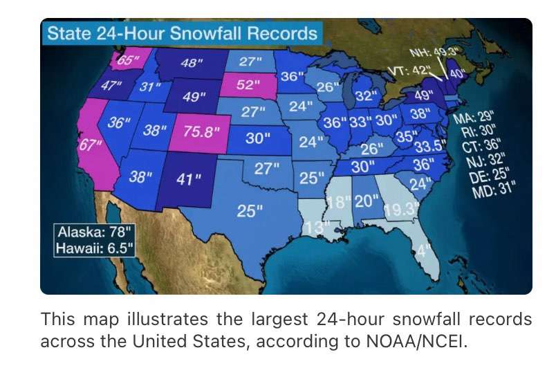
Couldn't help but notice IN and it's mismatch across state line with OH. As for MI changing, now IWX will be issuing warnings that will dead-end at the MI state line (at least in theory & knowing GRR).
And how do the LES counties of NWIN not get the same treatment as in MI? For that matter, could be said of IL & WI as well. Guessing the only way IL & IN beat MI on its state record 24 hr snowfall was due to some obscure LES events lost to time (SMH).
-
1
-
-
2 hours ago, Lightning said:
Some areas have had frost (rural). Most summer flower plants around my area are done with leaves dying back. Yesterday we got some sun and several of my neighbors where out cleaning them all out. I did my last weekend except my roses that require a true hard freeze so they are still blooming. I usually cut them back midwinter when I prune the cherry, peach and apple trees.
Summer flowers including Petunias were going strong here on the edge of the UHI in NW Wayne Cnty. I'm sure once you get N or W of here that changes quickly as you have seen up in Fenton area. DTW hit 38F and I'm hoping clouds can cooperate for a solid 32F Monday morning to get that monkey off our back.
-
2
-
-
I've seen the ground totally white under sugar maples in full red (Oct 2013). This year it's full colors blazing while summer flowers are still untouched by any true cold. Colors today across SMI are stunning despite no really frosty mornings yet. Vibrant colors were expected since we had a moist summer here.
-
1
-
-
On 10/20/2023 at 6:02 PM, Lightning said:
I understand the lake shore counties (LES belts). I agree that over here it makes little sense.
Josh could now get three 6.9" snow events in one winter and still not get warning criteria
.
Conversely, he could be forecasted 12+ and not even reach 6.9". If only the headlines meant a guaranteed total, lol
-
9 hours ago, michsnowfreak said:
I mean again. It did suck for us hardy WINTER lovers because it was a very mild winter, but snowfall managed to be around average.
Yes, strangely it had slightly AN plowable events and managed to reach within 3% of a normal seasonal total. But snow cover was a negative number, and Christmas at 57F and the entire holiday week 50s-60F blew chunks. I'd call it the mildest winter of my life that still managed avg snow, lol. If I did what many here do (try to grade a winter) I would have to admit that snow cover/retention is heavily weighted in my scoring and extended deep snow pack even more my thing would bump a grade.
-
On 10/17/2023 at 12:22 AM, michsnowfreak said:
Yes. It got down to 7° on Nov 13, 2019 which is the earliest single digits on record for Detroit. The bitter cold and deep snowcover before hitting mid November was surreal and clearly not a sign of the winter that was on the way (although we did get some other good snows, it was mild).
Translation - it sucked.
-
2
-
-
On 10/14/2023 at 7:11 PM, michsnowfreak said:
What IS a realistic hope is for a good stretch of deep Winter in any given season. A snow season often spans six months between first and last flakes, so not unreasonable to get some deep Winter stretches.
Good outbreaks of CAW seem to last only about 6 wks max. It is the rare events like the Jan '85 flip that may exceed that. Less than 6 wks ofc happens way more often.
-
Best vid I've seen on The Mitt's darkest day of severe wx:
-
10 minutes ago, luckyweather said:
Campi Flegrei supervolcano in Italy acting like it’s going to blow soon. Last week the US DoD told staff in the region to have a go bag ready at all times. Climate wise it could go either way / so much ash we keep a low latitude snowpack all year for a year, or flood the atmosphere with so much c02 the warming gets a hit of rocket fuel. Something to keep an eye on.
Does anyone know how much ash that large eruption in the Pacific generated?
-
1 hour ago, michsnowfreak said:
Agree on too much climo in the models these days, but thats why Im not leaning towards a warm winter (not saying its going to be cold). The seasonal model consensus is surprisingly tame (less than 1 degree F warmer than average), so imo with a nino in place, if I dont see the models torching thats a good sign.
I disagree on the "we are becoming less of a snowcover region". Its always been variable and we have never been the type of region to be snowcovered all winter, regardless of what the old fabled wives tales say about going uphill. Some winters are whiter than others, but when you average out every 10 years it stays relatively steady. Im a snowcover guy, but I know hoping for a 2013-14 or 1977-78 is unrealistic. Just can always hope lol. Thats why I laugh when people who DONT care about snowcover get so worried about temps. If all you care about is snowstorms and not their lasting impact, then it shouldnt matter whether the winter is forecast warm or cold at this latitude, it all depends on storm tracks.
Average Annual number of days with 1"+ snowcover per decade at Detroit
1920s- 51 days
1930s- 42 days
1940s- 49 days
1950s- 47 days
1960s- 57 days
1970s- 57 days
1980s- 47 days
1990s- 37 days
2000s- 51 days
2010s- 53 days
2020s- 46 days (thru 2022)1920-2022 avg: 49 days
") Yep, that's why I'm hoping for another 81-82
Yep, that's why I'm hoping for another 81-82
-
2
-
-
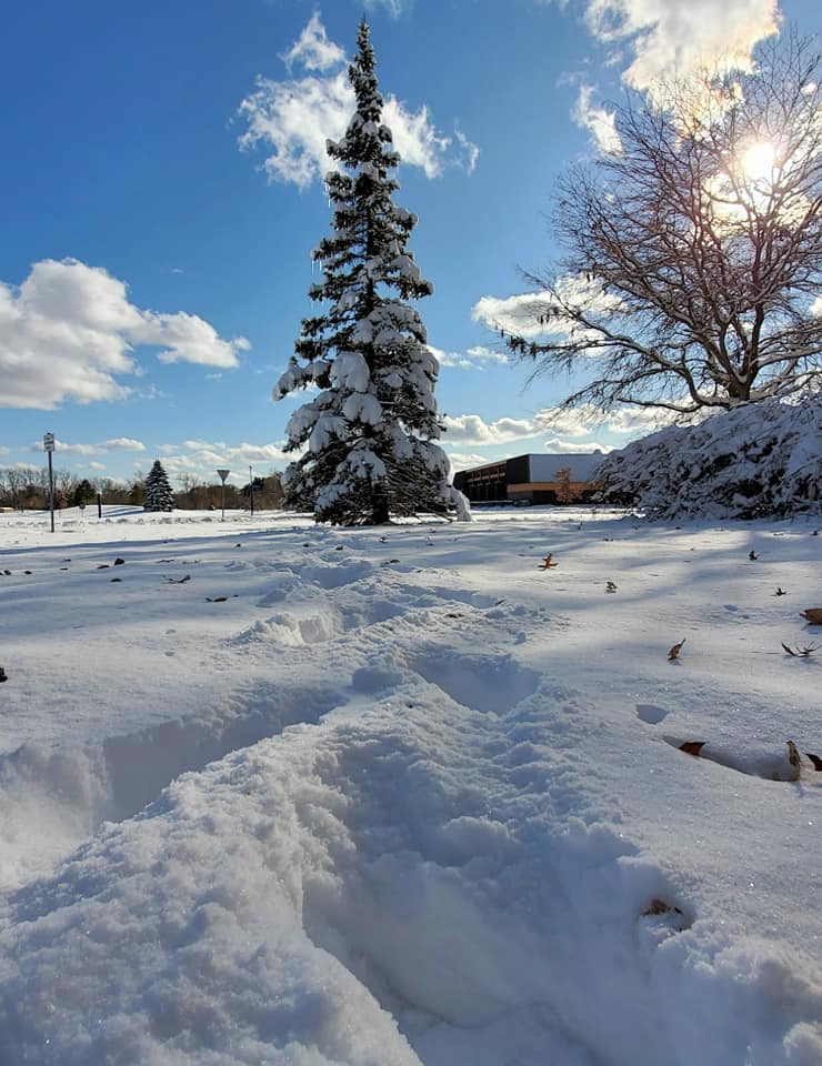
1 hour ago, michsnowfreak said:
It was quite a sight for so early in the season. The 9.2" at DTW is actually the largest November snowstorm on record, edging out 9.0" on Nov 15/16, 1932. Also, the snow stayed on the ground 10 days. Also, that was a very late leaf drop so some trees still had colorful leaves on them and it made beautiful scenes.
Photos from Nov 12, 2019.
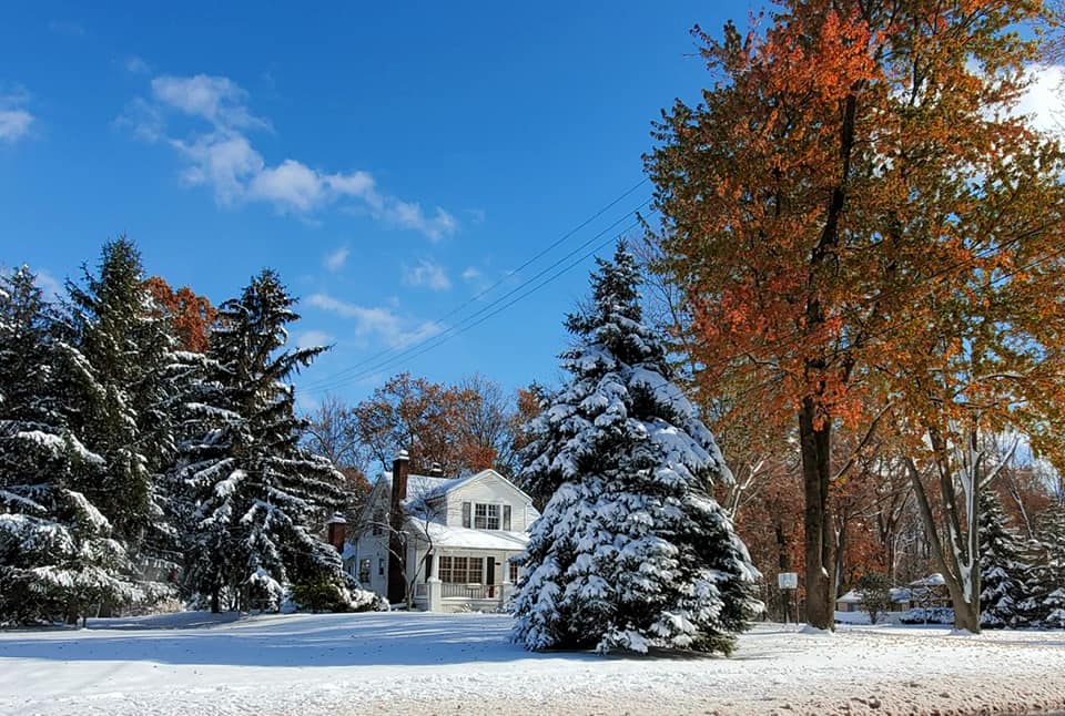

1st pic is October-December 11th
-
1
-
Winter 2023-24 Longrange Discussion
in Lakes/Ohio Valley
Posted
As @michsnowfreak posted, it wasn't a complete whiff for Detroit. Even the city reported 5" depth, and Pontiac was 10". But it was one of those shoulder season systems just cold enough to snow, and a week later only piles remained. Jackson and the Tri-Cities regions were both epicenters and no doubt memorable similar to my own April '75 Big Dog experience.