

RogueWaves
-
Posts
2,256 -
Joined
-
Last visited
Content Type
Profiles
Blogs
Forums
American Weather
Media Demo
Store
Gallery
Posts posted by RogueWaves
-
-
6 hours ago, cyclone77 said:
Was a very potent clipper that dropped 6-10" of snow from MSP down through northern IL into IN and KY.
I wasn't even aware back then, but have seen this and thought "wow, that was kind of an odd system"
-
 1
1
-
-
KS and WISCO putting up some numbers the last 24 hrs:
-
1
-
-
17 hours ago, michsnowfreak said:
Actually steve's criteria is all about rates, and that's what I was referring to on Nov 19, 2022. Obviously less than two inches of snow is not a heavy amount of snowfall but the fact that it came in in a blinding band is what I was referring to.

Haha, yep. Really, it ripped but it was after dark, I barely saw it twice out my window and here all 0.9" fell in about 30 minutes. By the time I realized it was "happening" it pretty much was just enough time to make that post and it was over. Then I really got the bigger shaft with this year's version. But, I will acknowledge that not ALL has been bad since moving here. I give 3-3-23 very high marks. Very hard-hitting and impressive storm with some ++SN.
-
1
-
-
1 minute ago, HillsdaleMIWeather said:
LOCK
IT
IN
For WV?
-
4 hours ago, Stevo6899 said:
josh's criteria for heavy is different than ours....
3 hours ago, Malacka11 said:Just my $.02 but -assuming I'm reading that right- 1.7" in two hours or less while accounting for November ground temps sounds like a pretty decent thumping to me.
I would prefer the word "intense" which it indeed was just like the recent Squall Warned event. Mostly jabbing at him because I only got half his total. Even less this year. Stacking tenths will always have a lame feel.
-
2
-
-
2 hours ago, michsnowfreak said:
We had that heavy frontal snow thanks to the lake Nov 19th, kinda similar to Nov 27th this year. The lakes definitely help out when synoptic doesn't.
It would appear there are thread the needle chances the first half of December, but it will be mild. Of course the potential turn to colder/stormy around Christmas is what has my early attention.
This is heavy?

And yes, I agree, it was exactly like what repeated this 11-27 as your area got a direct hit and I got half here (0.9), lol
-
About half an inch of RN here so far. Super dreary late autumn day.
-
First real snow threat wasn't until 12/23 last winter over here. Followed by another month of boring crap.
-
3 hours ago, michsnowfreak said:
There have been many instances where a drier than average winter produced above average snowfall. What happens this winter though remains to be scene.
I scene what you did there!
")
-
 3
3
-
-
Could we have a dry winter, and still have a decent amount of snow?
-
3 hours ago, cyclone77 said:
Pretty dry month overall for most of the region. DVN/MLI/here will finish with just 0.62"/0.71"/0.77".
Not a wet look - anywhere. And tomorrow's event will be a day late to help November.
-
 1
1
-
-
Hoping the MJO visit to the warmer phase(s) is not a prolonged event.
-
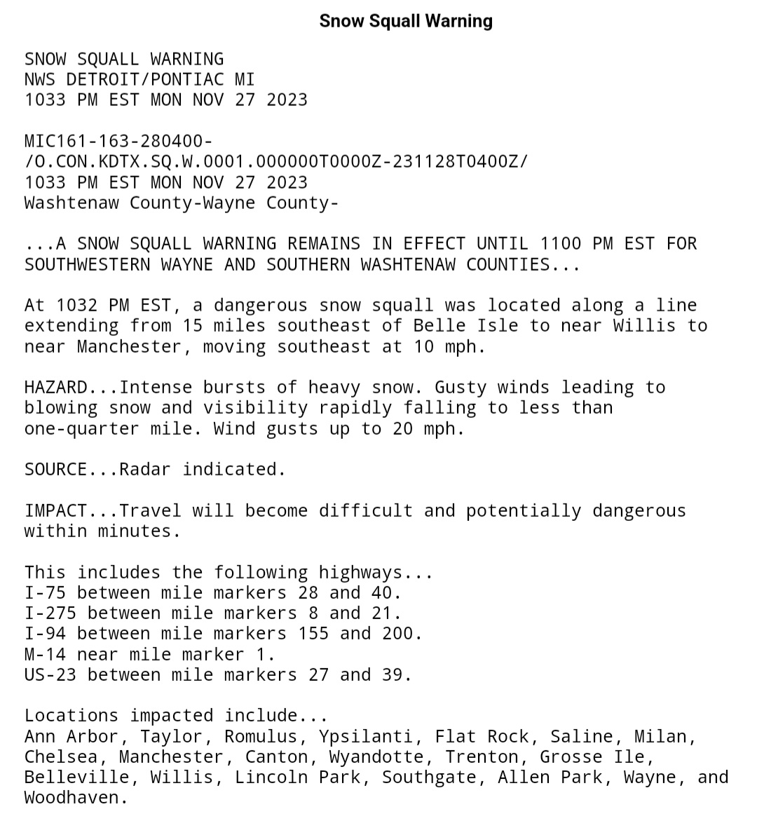
10 minutes ago, michsnowfreak said:
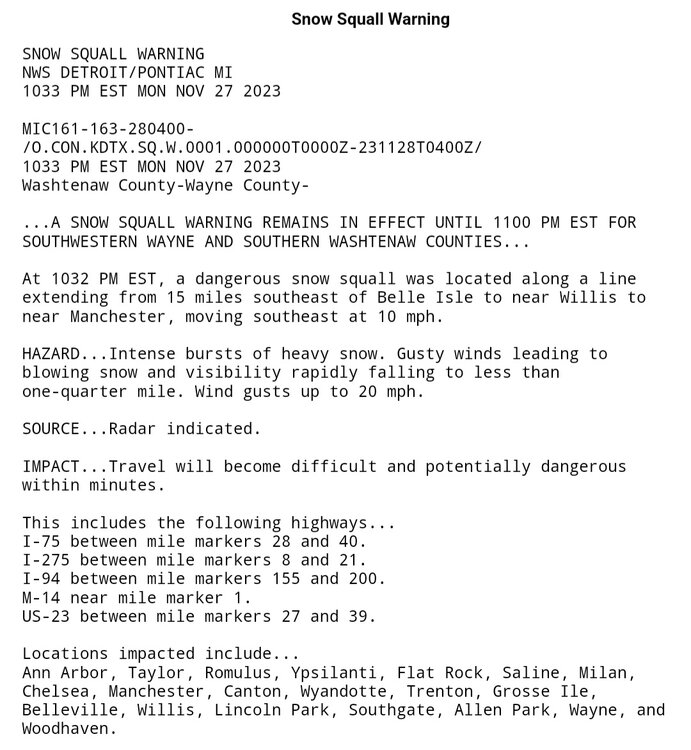
The squall was very intense, as I posted in the November thread. Completely different here and there lol.
Canton- 1.6" sun, 0.5" mon
Wyandotte- 0.2" sun, 1.7" mon
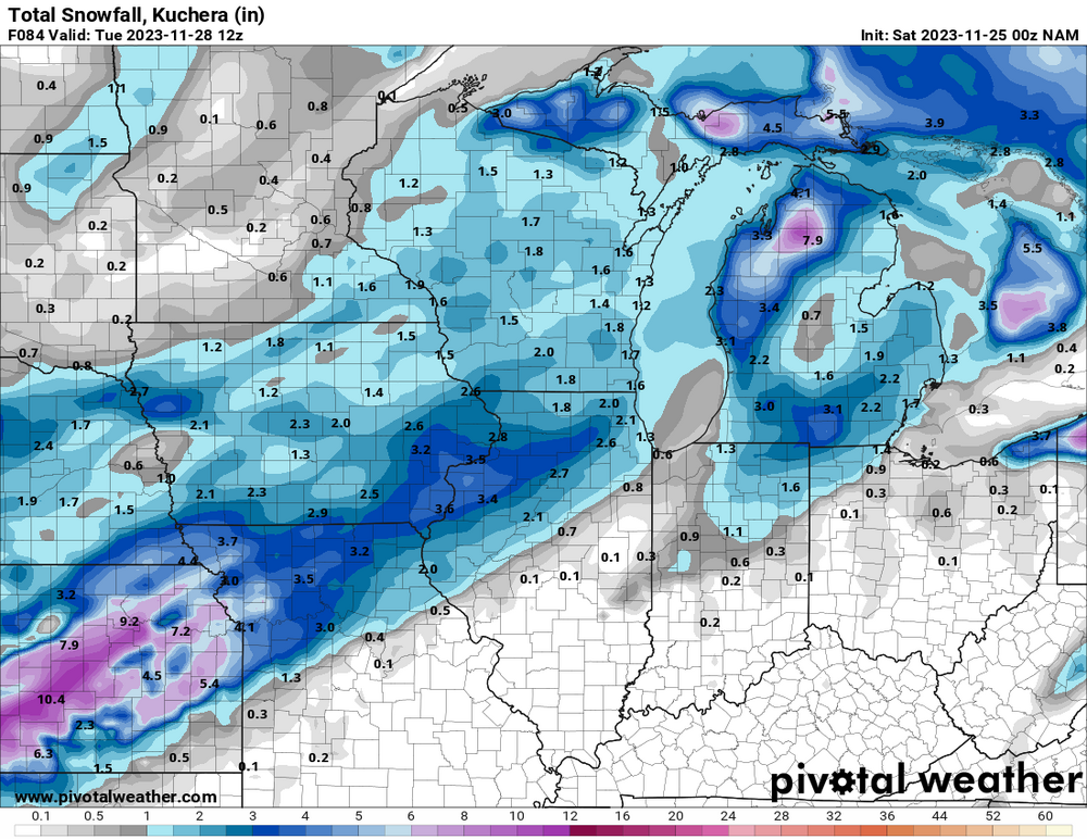
I was hoping to score the streamer to really make the event an over-performer. But hey, no complaints on verifying an 84 hr NAM run, lol
-
2
-
-
5 hours ago, michsnowfreak said:
It was legit. It was almost like an unintentional storm chase for me. My brother wanted to go downtown Detroit to dinner and check out the Christmas stuff. The squall hit as we were out, and it was such a perfect atmosphere. I figured the band would weaken some as it headed south but still snow, but instead it strengthened. As we left Detroit it had tapered to flurries but we ran right into it and drove through it the whole way home, Visibility near zero by my house briefly. It was enough to disorient you if you didn't know where you were because the traffic lights were obscured until the last minute.
Congrats seems you have a magnet going again for these potent streamers.
-
1
-
-
On 11/27/2023 at 10:59 AM, michsnowfreak said:
Lightly snowing and blowing today creating a wintry feel. Looking forward to see what kind of lake response/banding we get this evening as a shortwave moves thru.
I saw Wyandotte in the Squall Warning. How was it for you? mostly S of me, but the 0.5" took me to 2.1" for the 2-part event.
-
1
-
-
2 hours ago, michsnowfreak said:
Haven't had snow since Halloween, though the ground has snow on it November 1st. It's gonna be a sloppy white rain in dtw but I'm interested in les band potential tomorrow
Been on/off pouring here since noon. Despite the steady 33F most everything has a layer of white. What one more degree could've done, lol. Certainly impressed with a nice performance on a S wind, warmest hours of the day, and very little climo support for acuumulating snowfall when Thanksgiving comes earlier.
Anyhow, beats what many east of me have going on like noted by@Stevo6899
-
1
-
-
On 11/15/2023 at 12:36 PM, HillsdaleMIWeather said:
Lock
It
In

It was WAY off regarding the KS snowstorm, but at least we are getting some of that shown in SMI. I'll consider that a win being it's only Nov.
-
50 minutes ago, michsnowfreak said:
Great post. Happy Thanksgiving all!
I 2nd that.
Who's ready for Lions football, turkey dinner, and measurable snowfall to round out the holiday weekend?
DTX:
QuoteThis system will begin to organize today as a cutoff low over the Four Corners region. Eventually a northern stream clipper will dislodge it into a more progressive open wave that reaches southeast Michigan on Sunday. There is still plenty of time to sort out the details, but this is the next meaningful chance for measurable precipitation with a strong signal for all snow. Over 90% of ensemble members across the solution space support this p-type, with further agreement from long-range forecast soundings that illustrate sub-freezing thermal profiles.
-
2
-
-
9 hours ago, HillsdaleMIWeather said:
If y'all wanna see some weenie shit look at New York

Cold HP's have been plunging down just east of us so it's a matter of time until it is cold enough to make the storms dump on NY/New England. Nino hand writing on the wall.
-
4 hours ago, michsnowfreak said:
November has been very benign. After starting with a dusting of snow on the ground, there has been quite a bit of sun.
11/8 was a significant system for much of SEMI but north of the 94 corridor unfortunately.
Now we are about to get the 2nd sig system so while there has been a lot of pleasant sunny days, it hasn't been a total snoozefest.
Hourly showing 0.82" at DTW. Hoping for an over-performer. Late morning looking quite raw with WC's in the 30s and ongoing SHRN.
-
1
-
-
1 hour ago, Baum said:
agreed. trends are made to be broken.
From my post on another forum
QuoteActually, strong Nino's tend to have winter up til Christmas, then it vanishes for a couple months during the heart of winter. The record breaking storm in Nov 2015 is a classic example.
Not sure 15-16 was the best example to use, but it just came to mind quickly. It wasn't as bad for some of us as say 97-98 which might be the most classic example. I was having basically this same discussion with a poster from NWI where they've had a very slow start and he had posted how NWS Green Bay said "yep it looks like Nino's in full effect already". As @michsnowfreaknoted, it's actually NOT acting very Nino-like aside from the freak Halloween clipper thingy.
I like the current system. Basically the same S Stream track that treated DTW favorably last winter. We just need cold air. Temps were so marginal with every event last year. Maybe this gets colder JFM and acts more like a Nina. As long as it doesn't mimic 11-12
-
1
-
-
1 hour ago, Baum said:
so we can skip the December thread this year?
Dec '14 incoming
-
3 hours ago, Chambana said:
I knew things have been quiet, but how quiet? We have yet to make a storm thread this fall, and judging by the long range we are gonna be waiting awhile.
DTW's coldest high since the 1st. Currently in the 30s with a WC below freezing as a system heads this way. I'm fine with this for November. This is better than a premature snowstorm like say 11-11-19.
If it's going to be split-flow, aka S Stream dominant then we just need it a bit colder than last winter which basically featured that same Nino styled pattern. A repeating theme has been these cold pools of air just NE of here (where it is currently in the 20s) feeding into this region. Not ideal, but work-able imo.
-
Recent systems (except sneaky one on 11/8) have all fizzled out as they came this way, fwiw. I am watching this Tue-Wed S Stream system in hopes it actually has legs and doesn't crap-out. Would boost my hopes for winter a bit.
-
1
-


December 2023 General Discussion
in Lakes/Ohio Valley
Posted
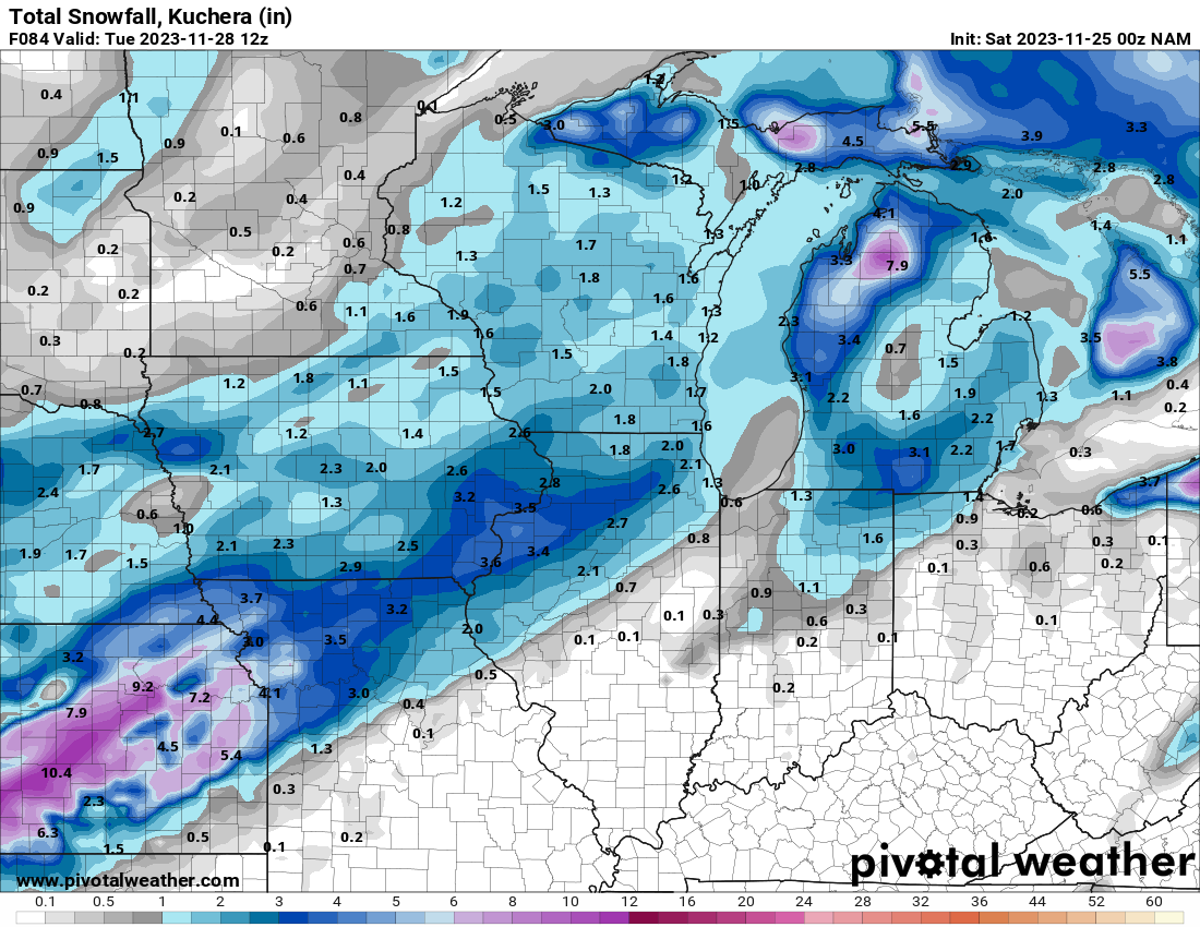
DTX (summary = gonna stack some more tenths)
Shortwave tracking through the Dakotas this afternoon and slipping
into central Indiana by 12z Tuesday. Question is will this system
still be strong enough and far enough north to support precipitation
slipping north across the southern Michigan border. Based on the
bulk of the hires solutions, and seeing 850-700 MB omega/forcing,
the answers appears to be yes for areas along and south of I-94,
with less confidence as one heads north. Mean temperature in the 850-
700 MB layer looks to be -10 C. 12z NAM still maintains a closed
surface low/low level circulation through 18z Tuesday, which should
be good enough with 925 MB temps of -2 to -3 C. Any layer above
freezing is right at or just above the surface, so snow is expected
to accumulate, especially after we drop into the upper 20s/near 30
degrees tonight. Accumulation around half an inch along and south of
I-94 appears likely, and will then taper off pops quickly as one
heads north.