winterymix
-
Posts
6,337 -
Joined
-
Last visited
Content Type
Profiles
Blogs
Forums
American Weather
Media Demo
Store
Gallery
Everything posted by winterymix
-
Major Hurricane Florence: STORM MODE THREAD
winterymix replied to stormtracker's topic in Tropical Headquarters
OUTLIER. Everything is converging on extreme NE SC, all of NC, portions of VA. -
Major Hurricane Florence: STORM MODE THREAD
winterymix replied to stormtracker's topic in Tropical Headquarters
History and progged probability of hurricane force winds. https://www.nhc.noaa.gov/archive/2018/FLORENCE_graphics.php?product=wind_probs_64_F120 -
Major Hurricane Florence: STORM MODE THREAD
winterymix replied to stormtracker's topic in Tropical Headquarters
KUDOS to the NWS. Images from the GOES 16 are so crisp. The models are converging very nicely. The NHC has been very silky smooth with updated forecasts. The NHC formed an early consensus and track shifts have been small angle shifts. People in the path have days of warnings and time to prepare. It would be nice if the EURO and GFS can learn to play nicely with each other. -
Major Hurricane Florence: STORM MODE THREAD
winterymix replied to stormtracker's topic in Tropical Headquarters
I ran the HMON-full and HWRF-full. Both have land full at the far north portion of the SC coast. One model takes the storm WSW and slows it down, the other goes WNW at a little bit faster clip. I think climatology favors the WNW route. Regarding the terrible-izing going on in these threads, Godzilla is not coming. Storm strength will be high-4 to a brief lowend-5 for a couple of days at sea. By the time it makes LF, sheer may take it down to a low-3. Wind will not be the killer, torrential flooding will be the risk and power failures from trees coming out of softened ground. Deaths should be largely preventable if people listen. -
-
He's fallen pray to the cryptocurrency overlord.

-
Adding my voice to those that are sympathetic to not wanting to spoil your vacation. Want to contract with my son's server farm?
-
Just don't conjure up the Kraken.
-
My employer's IT dept. will put this website on the forbidden list if problems aren't fixed. This is toxic:
-
Still occuring
-
Updated GFS indicates the OTS solution holding.
-
With satellite animation, NW aspect of inner eye wall looks to be eroding perhaps from dry air ingestion and/or upwelling of cooler ocean temperatures. With so much major hurricane traffic, latent heat of the west Atlantic is being effectively mixed out.
-
-
Jose is functioning somewhat like a cut off low. It is a hybrid with slight residual tropical characteristics. The baroclinic zone associated with the Gulf Stream provides enough latent heat to keep a system going. Jose has several levels greater vorticity than a weak depression or open wave. Jose is a picture of equilibrium, slowly weakening with very weak steering currents. As Jose weakens, it will become less stacked much like a decaying mature cut off low where the various upper levels loose register with the SLP.
-
The August 21, 2017 Great American Eclipse
winterymix replied to ice1972's topic in Weather Forecasting and Discussion
I'm thinking of something like this: http://tropicalsails.com/solar-eclipse-tour-2019/ Not sure I want to kind out what a 3 star hotel is like down there. -
The August 21, 2017 Great American Eclipse
winterymix replied to ice1972's topic in Weather Forecasting and Discussion
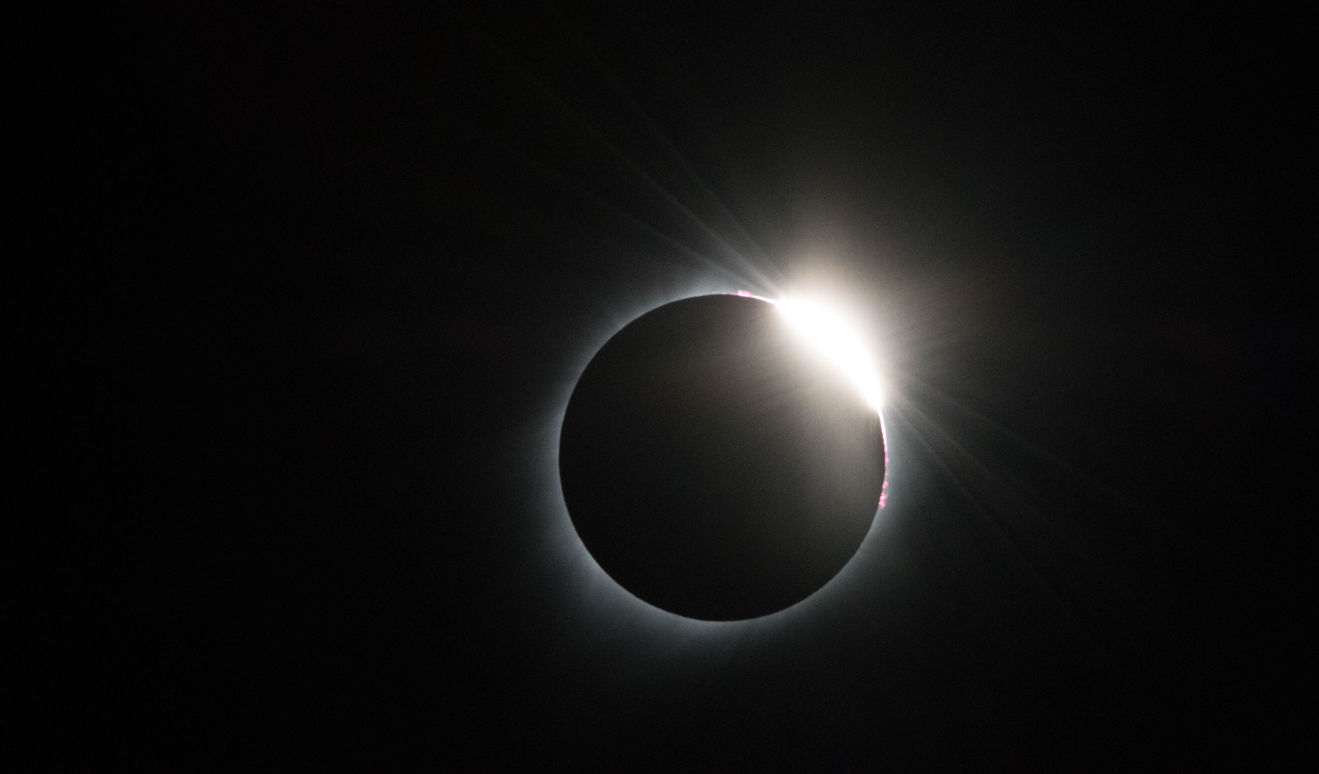
Nice comments from everyone. I did definitely see the shadow bands appearing against an off white plastic tent. Took a photo that shows nothing. These are mysterious and poorly explained and nearly impossible to capture in a photo. BTW, I counted on the NAM cloud cover maps at instantweathermaps.com. For all the NAM hatred, these maps did quite well for me. During the excitement, I mis-programmed my Nikon for ISO 3200 at 1/4000 second. Modern cameras are amazing, it still captured an image. Diamond Ring for y'all.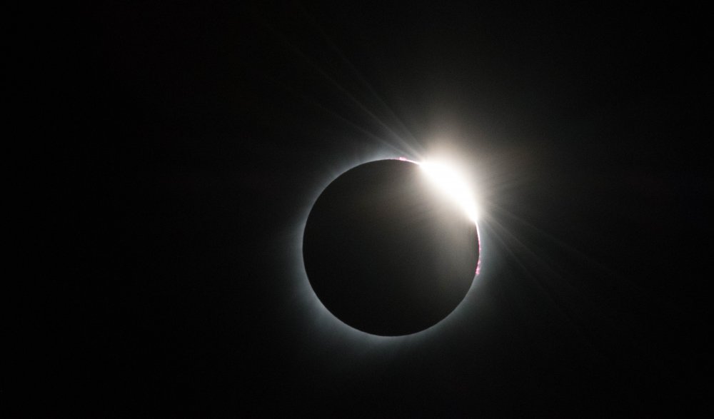
-
The August 21, 2017 Great American Eclipse
winterymix replied to ice1972's topic in Weather Forecasting and Discussion
Just like sex, intense over too soon gonna be a wait until the next one -
The August 21, 2017 Great American Eclipse
winterymix replied to ice1972's topic in Weather Forecasting and Discussion
Impressed, want to know of Gallatin was skill or luck. Ste Geneviere, mo getting dim out and some cumulus, hopefully they disipaite -
The August 21, 2017 Great American Eclipse
winterymix replied to ice1972's topic in Weather Forecasting and Discussion
made it to Festus, near CL Got my shortwave for WWV -
The August 21, 2017 Great American Eclipse
winterymix replied to ice1972's topic in Weather Forecasting and Discussion
We are headed for FELIX VALLE HOUSE STATE HISTORIC SITE in SE Missouri in case you want to join us. 443-789-9680 -
The August 21, 2017 Great American Eclipse
winterymix replied to ice1972's topic in Weather Forecasting and Discussion
In St. Louis hotel. Easting Snyders pretzels, BRISK lemonade, comedy on CNN. Thinking of leaving at 5 am for the area between Hopkinsville and Carbondale. GFS is clogged with clouds and the hated NAM is favorable. Bust heartbreak, anyone? -
The August 21, 2017 Great American Eclipse
winterymix replied to ice1972's topic in Weather Forecasting and Discussion
Same. Here at STL. Humid cloudy sweaty day. Much incertainty for tomorrow. Nowcasting time. Water vapor loop. -
The August 21, 2017 Great American Eclipse
winterymix replied to ice1972's topic in Weather Forecasting and Discussion
Jerry, it is still too early to pick a clear spot among patches of clouds. So the GFS image here is going to change. But if it stays mostly clear from SE MO into N and NC TN, then we've got a good sense of where to be.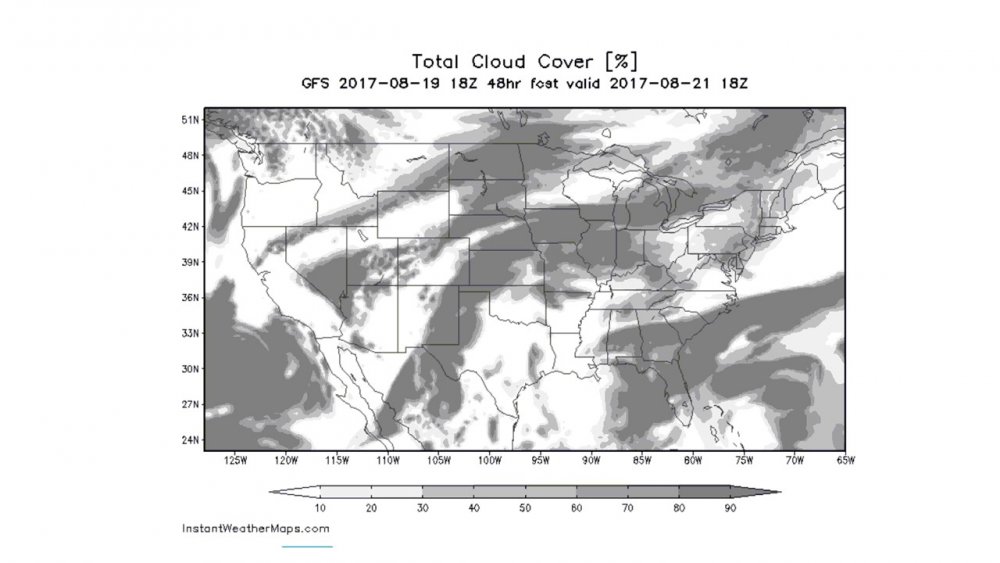
-
The August 21, 2017 Great American Eclipse
winterymix replied to ice1972's topic in Weather Forecasting and Discussion
I'm concerned . The models have trended more cloudy for about three runs now. -
The August 21, 2017 Great American Eclipse
winterymix replied to ice1972's topic in Weather Forecasting and Discussion
Jerry, I guess so. It seems that having a stew of very weak steering current in the lower mid-West leads to a ton of non-specific clouds, some of which are debris from decaying thunderstorm clusters.