winterymix
-
Posts
6,337 -
Joined
-
Last visited
Content Type
Profiles
Blogs
Forums
American Weather
Media Demo
Store
Gallery
Everything posted by winterymix
-
The August 21, 2017 Great American Eclipse
winterymix replied to ice1972's topic in Weather Forecasting and Discussion
Jerry, I guess so. It seems that having a stew of very weak steering current in the lower mid-West leads to a ton of non-specific clouds, some of which are debris from decaying thunderstorm clusters. -
The August 21, 2017 Great American Eclipse
winterymix replied to ice1972's topic in Weather Forecasting and Discussion
kill-I kill-I kill-I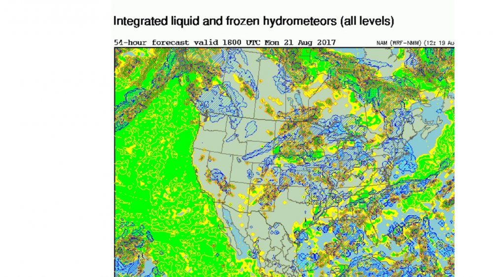
-
The August 21, 2017 Great American Eclipse
winterymix replied to ice1972's topic in Weather Forecasting and Discussion
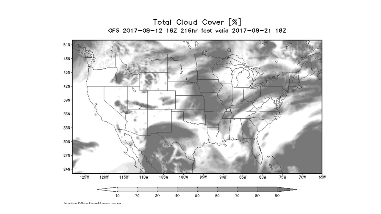
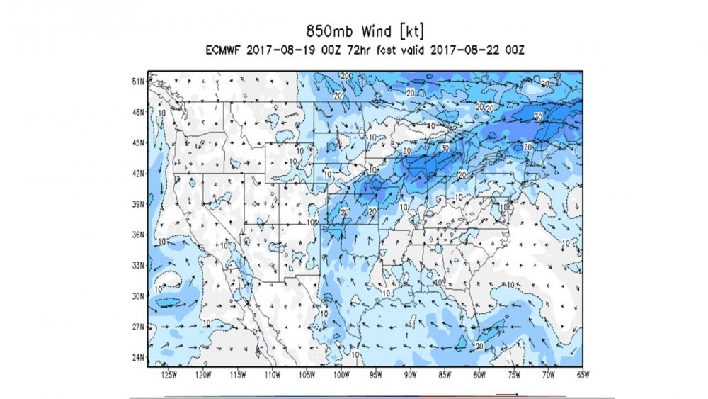
Guys, the GFS is trending cloudier with each run. I've attached cloudiness and 850. Jerry, I have no clue as to how you picked north-west-central TN but it looks to be a nice [partly cloudy] choice based on the current numerical guidance. STL AFD: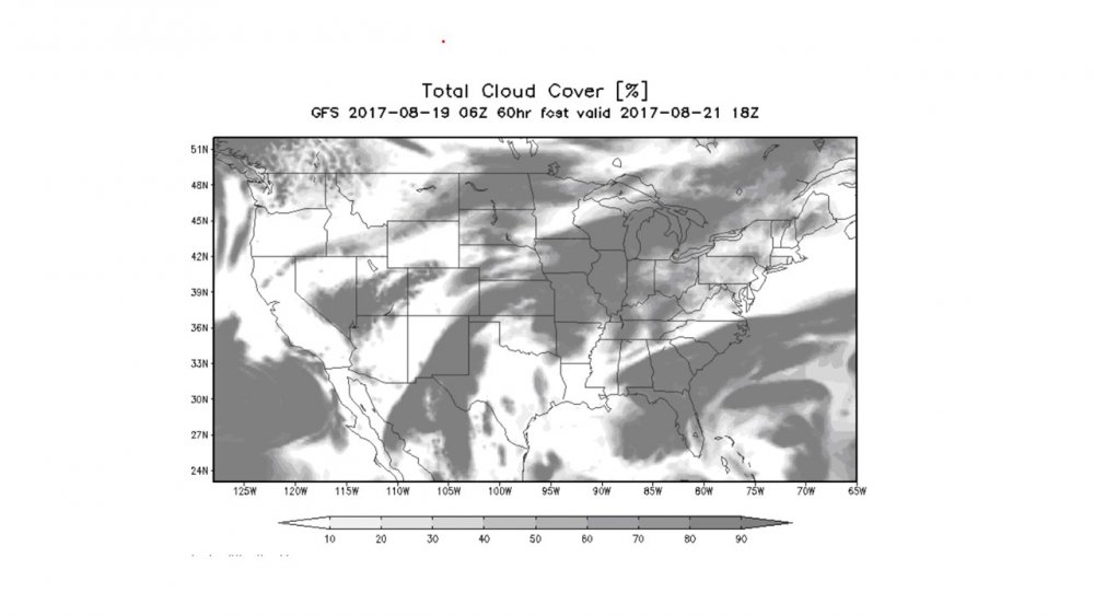
-
The August 21, 2017 Great American Eclipse
winterymix replied to ice1972's topic in Weather Forecasting and Discussion
Looking like the correct play for now. -
The August 21, 2017 Great American Eclipse
winterymix replied to ice1972's topic in Weather Forecasting and Discussion
NWS at STL suggests Carbondale, southern IL -
The August 21, 2017 Great American Eclipse
winterymix replied to ice1972's topic in Weather Forecasting and Discussion
Nothing but soupy summer heat and humidity with very weak lifting triggers. -
The August 21, 2017 Great American Eclipse
winterymix replied to ice1972's topic in Weather Forecasting and Discussion
Hello red tag meteorologists: any probabilistic cloud forecasts for the centerline? GFS looks more cloudy with each run. -
The August 21, 2017 Great American Eclipse
winterymix replied to ice1972's topic in Weather Forecasting and Discussion
Dream conditions would be cold front passage with a drop of dew points. Instead, this is semi-tropical humid soup. Hopefully pop up showers and thick clouds will shift north along the edge of that ridge which wants to trundle north (slowly). Wouldn't know for sure until 24 hours before the event. Wishing clear skies to all the eclipse chasers. -
The August 21, 2017 Great American Eclipse
winterymix replied to ice1972's topic in Weather Forecasting and Discussion
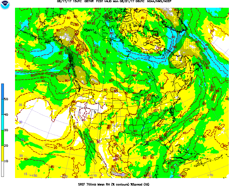
Knowing too little about cloud forecasteses, I'ma just going post the 700 mb sref for the AM hours before totality... Most of the US has a moist juicy column of summer humidity except the Oregan rain shadow desert and the Idaho-Wyoming-Nebraska fly over landscape. I'm hoping MO has sunny skies from noon to 2 pm somewhere on the CL The trend was to increase clouds in MO from 20/30% to more like 40%...fOOK. Fingernail chewing commence!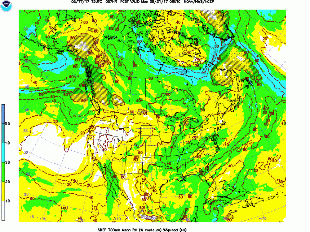
-
The August 21, 2017 Great American Eclipse
winterymix replied to ice1972's topic in Weather Forecasting and Discussion
Then Missouri-Tenn. corridor looks....hot and 30% clouds. Am more concerned with cirrus than mid level clouds. Cumulus and mid-level can dissipate between 1st and 2nd contact. Those smarti-pants in east Oregon may have 80s and sun.... -
The August 21, 2017 Great American Eclipse
winterymix replied to ice1972's topic in Weather Forecasting and Discussion
Traveling with another 60+ yr old colleague.. We need T shirts that say short Jew nerds . com I will mention it to him. But Gallitin is 340+ miles from St. Louis. Should have opted for East Oregon/Idaho. Our plan is to stay at a Hilton on west side of St. Louis and take rental vehicle to centerline that seems to have best skies within two to three hour drive of west St. Louis. Should you want to change your flight to STL, we already have a vehicle and hotel. -
The August 21, 2017 Great American Eclipse
winterymix replied to ice1972's topic in Weather Forecasting and Discussion
Fair point. This is my fourth total. The new Nikons can be set with a built in intervalometer and built in exposure bracketing. I can get nine exposures bracketed with a range of shutter speeds after one command to the camera. So I can get correctly set exposures and still view with the naked eye. The Nikon D7500 can capture exposures almost good enough for National Geographic. Jerry, this is a must-read: Sperling's Eight Second Law - All Total Solar Eclipses Last Eight Seconds -
The August 21, 2017 Great American Eclipse
winterymix replied to ice1972's topic in Weather Forecasting and Discussion
People are hush, hush about where they are observing/chasing. I'm bringing four Nikon dslrs, three or four tripods, a little folding table and some binoculars. Can't anyone observing near the CL in MO share some location observing tips? -
The August 21, 2017 Great American Eclipse
winterymix replied to ice1972's topic in Weather Forecasting and Discussion
I'm fantasizing about displaying a thermometer at two meters and with some sort of sun shade. It would be interesting to record 2m temperatures during the event. I 'm reading that with favorable conditions, the 2m temp. can drop 15 to 20 degrees. I'm guessing dry soil, no clouds, no pollution, no wind shear will allow quick transfer of outgoing radiation starting about 40 minutes before second contact. I'm sure these stats will be gathered across the centerline and near center. Hopefully a lot of good temp logs will emerge. Can any-of-ya suggest a reasonably priced air thermometer I can buy before Friday, not the POC in Home Depot. Any tricks on a legit way to provide sunshade? Will the temps count if I do not have motorized ventilation? Thanks to the red taggers, keep those probabilistic forecast products coming. -
The August 21, 2017 Great American Eclipse
winterymix replied to ice1972's topic in Weather Forecasting and Discussion
Where? I'm looking at MU Extension in Howard County. -
The August 21, 2017 Great American Eclipse
winterymix replied to ice1972's topic in Weather Forecasting and Discussion
Jerry, I'm guessing the GFS 700 mb (rel humidity, omega, heights, winds) chart gives us a rough idea of cloud cover. For eclipse time, it seems that the Ozarks (MO/TN) area is under an area of stationary flow/August scattered showers. My hunch is "partly cloudy with 30% chance of showers". I'm guessing that verification is poor at 7-8 days but still the rough ideas are there. What do you think? -
The August 21, 2017 Great American Eclipse
winterymix replied to ice1972's topic in Weather Forecasting and Discussion
If we each put aside $175 a month for 23 months... -
The August 21, 2017 Great American Eclipse
winterymix replied to ice1972's topic in Weather Forecasting and Discussion
Jerry, see you on July 2, 2019 — Total Solar Eclipse — La Serena, Chile -
The August 21, 2017 Great American Eclipse
winterymix replied to ice1972's topic in Weather Forecasting and Discussion
nice link http://www.weather.gov/media/lmk/pdf/eclipse/eclipse_long_lead_DSS_LMK.pdf -
The August 21, 2017 Great American Eclipse
winterymix replied to ice1972's topic in Weather Forecasting and Discussion
What is the verification score for a 200+ hour GFS cloud cover forecast? Flame proof anti trolling shield **on**
-
Hey Randy: nice body of work in AP. You have been solid for 14 months, HRC vs. Trump.
-
Best Mid-Atlantic winter storm of the last 50 years
winterymix replied to AnEndlessMaze's topic in Mid Atlantic
I'm going to push the definition in this thread. For me, the best storm was February 14-17,1958. I was four years old and was in my Dad's car. He had to pull over and bail a few blocks from home because of the road conditions. I remember him having to carry me home. That got me interested in snow. BTW, a city plow smacked his car and the city had to pay to fix the body work. -
May 2013 at DCA is finalized at 66.7 degrees, the 45th warmest of all-time, vs last year's 71.4 degrees, the 3rd warmest. This year's meteorological spring (March, April, and May) at DCA is finalized at 56.5 degrees, the 43rd warmest. That compares with last year's record-breaking spring average of 62.2 degrees. The 5.7 degree decline from one spring to the next is the second greatest in DC history, topped only by the 5.8 degree decline between 1991's 60.0 degrees and 1992's 54.2 degrees. Portions of this May had a brisk feel on some days, some folks would say those days felt harsh. Some folks out for a stroll had winter clothes on. Nor meant to be a scientific comment, personally, I found those cool days to be refreshing. RodneyS.: These temperature swings you are documenting can be random noise or can be a signal of increased volatility. Too soon to say.
-
We're having a drought of precip. Since Sandy, we are about 3 inches in the hole. January looks increasingly warm and dry. The dreaded Pacific zonal firehose.
-
Wouldn't it be special if either BWI, DCA, or LWX set a record for the earliest 100 degree record in modern times this year? DCA and BWI, June 05, 1925.