Shades
-
Posts
362 -
Joined
-
Last visited
Content Type
Profiles
Blogs
Forums
American Weather
Media Demo
Store
Gallery
Everything posted by Shades
-
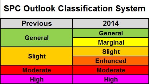
Since 2014 when the SPC changed classification systems, the general public and in some cases, municipalities and public authorities have failed to understand that enhanced is an extension of "slight risk". I still have this conversation with others that interpret "enhanced" as more potent than "moderate".... IJS.... Keep things simple for the simpleton.
-
Convective debris in eastern PA, and marine layer re-establishing from the south looks to thwart viewing times. This window of clearing, seems to be just that, a window of clearing. Mesoscale models have been stalwart in lackluster sky conditions/variably cloudy to overcast for some in the metro area. May even need an umbrella for "viewing," IJS...
-
Quasi-stationary BD CF/WF

-
Lots of local variability with temperatures in the metro area this afternoon. LGA remains in the low 60's on a NE flow off the Sound as of the noon hour observation. Mesonet station in central Queens in the 70's to near 80, while the South shore of Queens and JFK in the 60's on a southerly flow off the Atlantic. There will probably be late day high temperatures for those affected by wind off the water, LI Sound/Atlantic, ahead of the frontal boundary as we thoroughly mix the low levels to max; may be one of those scenarios where outflow boundaries ahead of convection spike temperatures briefly ahead of the front this evening.
-
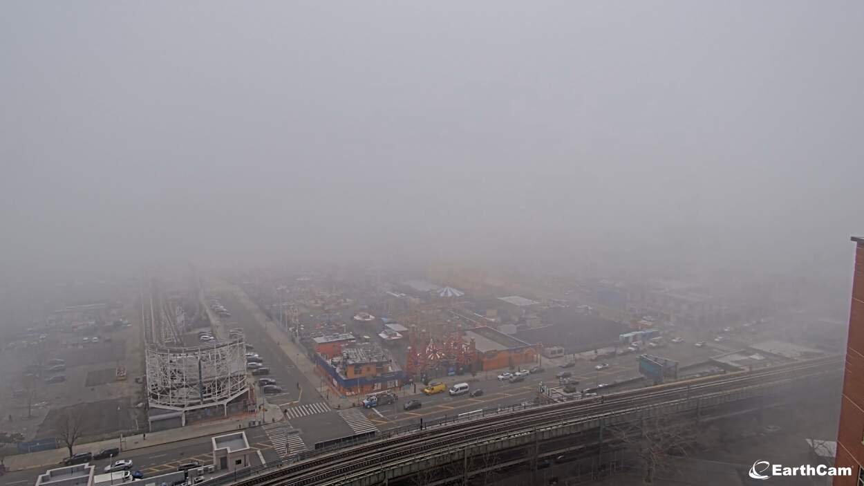
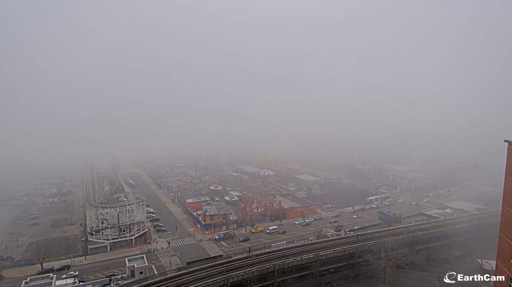
Marine layer/fog bank encroaching into southern Brooklyn and Queens. Coney Island, Rockaway Park in reduced visibility with this dense low cloud deck. Coney Island webcam verifies not a day to be on the beach https://www.earthcam.com/usa/newyork/coneyisland/?cam=coneyisland unless you're a seagull, or into this type of spring like microclimate on the shore.
-
Between hail tops.
-
Between hail tops.
-
Adding to confirmation of hail reports, Maspeth, Queens pea-sized smattering catching many people on their Saturday morning walks/drive by surprise. Seen pedestrians take cover under canopies and dash back to their car. Convection is very showery and sporadic, in partly cloudy intervals. Will be interesting to see what daytime peak heating will introduce to this airmass.
-
NWS issuing special weather statements for snowsqualls moving through Ithaca-Binghamton area this morning, highlighting wind gusts >30mph, reduced visibility <.25mile, and potential for a quick inch of snow for areas affected. This same band is reflected in high-res models to move through the metro area this afternoon-evening with some impacts - will be interesting tracking along. Given the subfreezing temperatures this may adversely affect this afternoons commute along with other diurnal activity developing in this anomalous arctic airmass. OKX doesn't seem as enthused with snow squalls this afternoon, citing dry low-levels, but these streamers have begat some surprises eg. CT/E LI last night with accumulating snow, where special weather statements remain as of this morning.
-
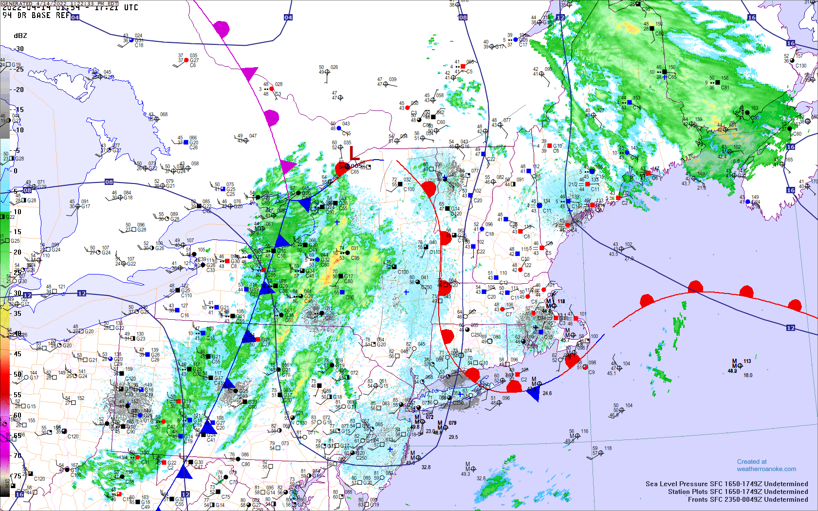
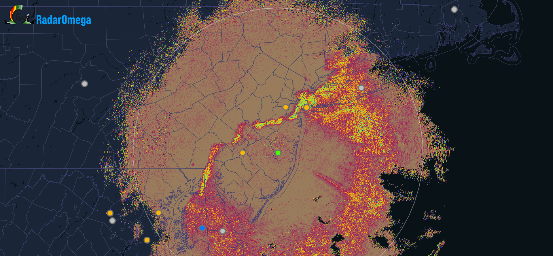
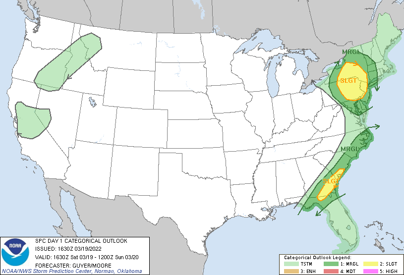
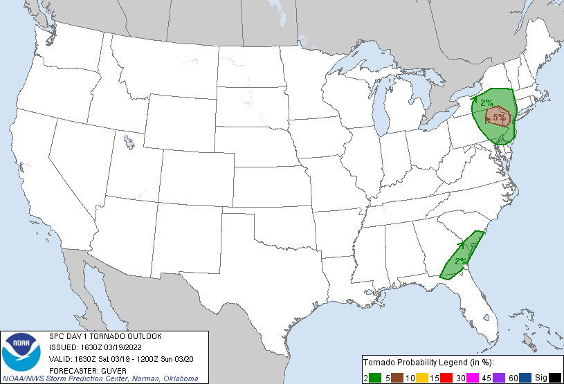
Dropped in to see if there was any disco on the severe threat for this evening. SPC has slight risk knocking on the door of NYC metro, with 2% tornado risk, increasing to 5% in NJ/PA and lower HV, west of the Hudson. ...Northeast/Mid-Atlantic States... A low-amplitude shortwave trough over the middle Ohio River Valley, and an associated 70+ kt mid-level speed max within its base, will continue northeastward and reach eastern New York/western New England and nearby middle/northern Appalachians this evening. Strengthening forcing for ascent and increasing deep-layer shear will influence an increasing broad but modestly moist (50s F surface dewpoints) warm sector. Storms should initially develop and intensify across west-central portions of Pennsylvania and New York through early/mid-afternoon. While warm sector moisture/buoyancy will not be robust (generally limited to 500 J/kg MLCAPE), it should be adequate for some severe low-topped storms. Relatively long/semi-straight hodographs atop a modestly curved near-ground (0-1 km) portion of the hodograph should support some low-topped supercells this afternoon, particularly across east-central/northeast Pennsylvania and far south-central New York. This is where a somewhat more focused potential for a brief tornado or two and/or severe hail may exist. Multicells/line segments capable of damaging winds are otherwise expected regionally through late afternoon and early evening.
-
LGA official NWS observer snow total from yesterdays storm: .9" It was good tracking, some of this thread was unreadable and I'm sure moderators had to dump salt on particular posts, some jumped off the ship too soon with the post frontal enhancement. 3" - 5" in the hills NW of the city according to OKX. Respectable event for Mid-March, as we made a run for the end zone with a field goal and punt into spring. From last nights AFD: Winter weather headlines have been dropped with the moderate snow band, associated with mid level deformation zone ahead of approaching mid level trough axis, sliding off SE CT/E LI shortly. Travelers should still exercise extra caution overnight for blowing snow for NW hills where 3 to 5" of powdery snow fell, and locally snow covered and icy untreated roads and walkways for much of the rest of the region from a dusting to couple of inches.
-
Not far from exit off the LIE 19 ramp, 69th Grand Ave.
-
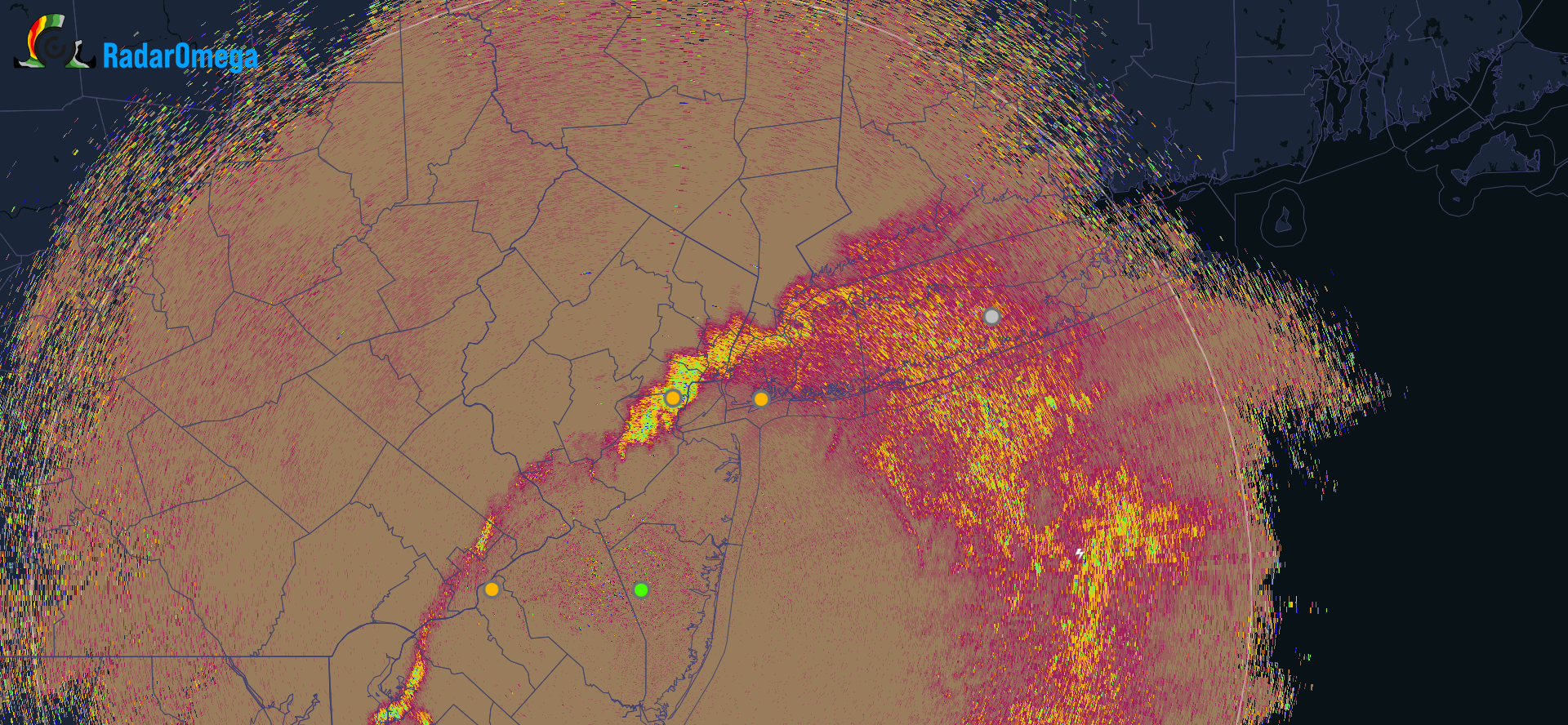
Correlation coefficient showing a lot of wiggling to the R/S mix line. Has progressed a few miles north in the metro area since last half hour, somewhat depicting a coastal front. Moderate sleet with a few big flakes mixing in Maspeth, Queens.

-
Rain and snow mix in western Queens.
-
For relativity, the NWS has Philly at freezing by 11am tomorrow; never rising above, and falling into the 20s by 1pm. That's how close the cold air is. This will be a race between thermal gradient and the moisture/lift exiting.
-
I wonder if WAA in advance of the system is also being subdued. Just casual observation, we have a mostly clear sky this evening area-wide, setting up for radiational cooling, even with the light southerly flow. This system is amplifying as it crosses the region, so it's not pumping the ridge till past our longitude.
-
I suppose climatology has weight in prognostic output, and this may be more evident when it's a bigger factor in mid-March, setting a very linear gradient, it even protracts around the metro Philly area.
-
I was about to inquire the same, this as most models have grid issues, but this looks bizarre for raw output, unless there's post-processing algorithms.
-
Snow is snow, not white rain. Nothing accumulates = still snow, not white rain. There's been instances of white rain on the west coast associated with dust/volcanic ash. The only white rain I've observed is a brand of shampoo. As weather observers, forecasters, why are we invalidating precipitation type just because it's March, just because it's marginal temperatures and just because it doesn't accumulate. It will be snowing tomorrow, not white raining. SMH

-
This thread was more active earlier in the week when there were more uncertainties and variabilities. It seems that just because a winter weather event may not deliver for some as hoped or wished, it garners less attention or even warranting further discussion i.e. impacts, nowcasting trends. IMO there is way too much emotional investment in this hobby - which I can imagine affecting people's mental health and furthermore appreciation of the science behind forecasting. Working in human services I often encounter what "chasing the high" does to people, whatever that "high" may be. There is indeed an adrenaline rush driven by the enthusiasm of this science, and there's nothing wrong with that - it's what drives the passion and discourse. Concerning what becomes subjectified by some, is how this hobby can almost become detrimental as gambling does. Granted, I don't think anyone, or many people are placing bets, but there seems to be a sense of risking the loss of something important by investing your time and attention, or other stakes such as reputation. Not sure what to make of this, but I wonder sometimes how the science is often being missed or overlooked. To this event, I find it really intriguing how much impact boundary layers have at the cusp of arctic high pressure. Climatologically, this is a very impressive discharge of cold air corresponding with wave interaction on a frontal boundary. The midlevel warming associated with that overriding the dense surface air, for a majority of the event at or below freezing for many. I think an interesting factor not given enough attention is the dewpoint depression and how that may impact further cooling as the event commences and even during it... it's really a battle between the surface and midlevel boundaries. Sleet dominating makes sense, and so does freezing rain in prone/untreated areas. If you live above a subway line, which is much of NYC-proper, ground temperatures will thwart any significant accumulation with slop, but elevated crossways, and pedestrian bridges, ramps, steps, may be hazardous for an extended time during Friday morning's commute. Even though roads may be fine, not everyone drives a car, and it's more hazardous to walk and break a bone, rib, or hip, than be in a vehicle during winter weather events such as this. Take caution ya'll!
-
Someone is bound to interpret this as an impending coastal rainstorm. Then again, stranger things have happened. For those just catching this snapshot without reading the rest of the thread: the coastal storm follows the weekend lead cutter on guidance, when the cold air is already established early next week, putting a frozen-event on the table. Guidance (as of now) however does not amplify the low to ride north into our latitude, and goes out to sea.
-
CAA on a northerly flow is notorious for abrupt temperature drops along the HV and points south. Consider the topography of the Hudson River and the relatively unimpeded flow for air to funnel south. In contrast, when CAA is on a northwesterly flow, it must traverse higher elevations of the Catskills/Poconos, and points NW, leading to a more gradual transition, often with drying/downsloping. This is a classic Hudson Valley FROPA for the area - it's almost like a backdoor coldfront.
-
Caldwell, Essex County Airport (KCDW) OBS 6AM: 59F (54 Dewpoint) 7AM: 38F (34 Dewpoint)