

Shades
-
Posts
362 -
Joined
-
Last visited
Content Type
Profiles
Blogs
Forums
American Weather
Media Demo
Store
Gallery
Everything posted by Shades
-
SVR/FF potential late today-Friday June 29-July 2, 2021
Shades replied to wdrag's topic in New York City Metro
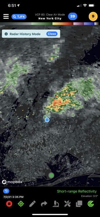
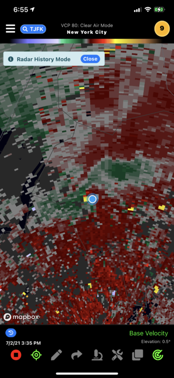
A very anomalous day with local boundaries galore from antecedent convection, an approaching vort max which seems to disrupt a very unstable airmass in a flow that isn't anything but sailing along. It's an atmospheric tug of war between the vorticity max to the west and the WAR to our east. -
SVR/FF potential late today-Friday June 29-July 2, 2021
Shades replied to wdrag's topic in New York City Metro
Landspout/week tornado in Maspeth Queens at 3:40-3:45PM, clean footage sans artifacts (mostly)... -
SVR/FF potential late today-Friday June 29-July 2, 2021
Shades replied to wdrag's topic in New York City Metro
So I'm in the process of putting the RAW video from the iphone into vimeo, may take some time and I have been shuffling with other obligations during this evening, remote work from home included. It was an interesting evening with the storms in Queens as they developed to backbuild and amid the boundaries at the surface, and apparently to cloud base there was enough for a spin-up. My location avoided much of the flooding just north of here however every cell has a base, and apparently I was right under one. -
SVR/FF potential late today-Friday June 29-July 2, 2021
Shades replied to wdrag's topic in New York City Metro
-
SVR/FF potential late today-Friday June 29-July 2, 2021
Shades replied to wdrag's topic in New York City Metro
-
SVR/FF potential late today-Friday June 29-July 2, 2021
Shades replied to wdrag's topic in New York City Metro
-
SVR/FF potential late today-Friday June 29-July 2, 2021
Shades replied to wdrag's topic in New York City Metro
I've got it on velocity scans. Radar omega app. from the doppler at JFK -
SVR/FF potential late today-Friday June 29-July 2, 2021
Shades replied to wdrag's topic in New York City Metro
Bucket list chased a tornado, down the block -
SVR/FF potential late today-Friday June 29-July 2, 2021
Shades replied to wdrag's topic in New York City Metro
-
SVR/FF potential late today-Friday June 29-July 2, 2021
Shades replied to wdrag's topic in New York City Metro
My weather friends, I overlooked that I have garage security camera footage at street level. Clear surface circulation. -
SVR/FF potential late today-Friday June 29-July 2, 2021
Shades replied to wdrag's topic in New York City Metro
Youtube also decided to re-orient and flip my video, smh. Raw source is primo. -
SVR/FF potential late today-Friday June 29-July 2, 2021
Shades replied to wdrag's topic in New York City Metro
I contacted UPTON with the included footage of previous captures. The uncompressed file is extremely sharp depicting the circulation and movement of debris as it evolves from east to west until dissipation. If someone can point me to a web based streaming service or allocate upload forum bandwidth toward such, I would contribute. -
SVR/FF potential late today-Friday June 29-July 2, 2021
Shades replied to wdrag's topic in New York City Metro
This construction tree guard was upright prior to event. -
SVR/FF potential late today-Friday June 29-July 2, 2021
Shades replied to wdrag's topic in New York City Metro
-
SVR/FF potential late today-Friday June 29-July 2, 2021
Shades replied to wdrag's topic in New York City Metro
-
SVR/FF potential late today-Friday June 29-July 2, 2021
Shades replied to wdrag's topic in New York City Metro
There was nary any rain during this localized event. And there was a calm at the end like it never happened. For orientation, the circulation moved EAST to WEST. -
SVR/FF potential late today-Friday June 29-July 2, 2021
Shades replied to wdrag's topic in New York City Metro
Thhis seemed to be very localized to my block, debris not in surrounding blocks, but as is in the video, localized broad cyclonic circulation in winds near or above 50mph. I have another video of 10k+ views of Isais in my channel. This may be attributed to localized geography. -
SVR/FF potential late today-Friday June 29-July 2, 2021
Shades replied to wdrag's topic in New York City Metro
-
SVR/FF potential late today-Friday June 29-July 2, 2021
Shades replied to wdrag's topic in New York City Metro
Nvm. I'm going to vimeo it. -
SVR/FF potential late today-Friday June 29-July 2, 2021
Shades replied to wdrag's topic in New York City Metro
I'm savvy enough to have an iphone but i'm in an app desert. Who knows of an app or service that will upload a 600mb video for web based streaming? Do I just use youtube? Suggestions? -
SVR/FF potential late today-Friday June 29-July 2, 2021
Shades replied to wdrag's topic in New York City Metro
Not Eliot. Between Grand Ave and Queens Blvd on 69th street, more specifically. -
SVR/FF potential late today-Friday June 29-July 2, 2021
Shades replied to wdrag's topic in New York City Metro
Near PS 229 -
SVR/FF potential late today-Friday June 29-July 2, 2021
Shades replied to wdrag's topic in New York City Metro
I have a tornado/landspout on video my weather friends. Reviewing footage at this time. Maspeth Queens at 3:40-3:50, great 3rd floor footage from near Ridgewood plateau (~100 ft elevation). -
SVR/FF potential late today-Friday June 29-July 2, 2021
Shades replied to wdrag's topic in New York City Metro
I just canvassed a few blocks at my residence. Large tree limbs down, siding, gutters blown down, and wide debris field, from east to west. These were EASTERLY winds in excess of anything Ive observered since owning a Davis weather monitor station pre-Y2k, and keeping observation journals in junior high. -
SVR/FF potential late today-Friday June 29-July 2, 2021
Shades replied to wdrag's topic in New York City Metro
Trees down in Maspeth Queens.


