
vortex
-
Posts
486 -
Joined
-
Last visited
Content Type
Profiles
Blogs
Forums
American Weather
Media Demo
Store
Gallery
Everything posted by vortex
-
Yeah, idk. Prolly a bit high Bourbonnais COOP is usually pretty conservative Kankakee County... Bourbonnais 7.5 in 0700 AM 01/13 COOP Kankakee 1.4 WSW 5.8 in 0600 AM 01/13 COCORAHS St. Anne 4.5 in 0700 AM 01/13 COOP
-
Wow, just turned on Earthcam TV for downtown and seen a lightning strike light the whole sky up. Impressive
-
Nice little squall
-
Couple pics from my walk through the neighborhood. Nice fall evening.
-
6 confirmed Tornadoes in LOT, one was about 2 blocks north of my house. Mostly tree and some roof shingle damage. https://www.weather.gov/lot/2023_07_28_SevereWeather
-

2023 Short/Medium Range Severe Weather Discussion
vortex replied to Chicago Storm's topic in Lakes/Ohio Valley
A bit late to the party but I took this picture in the evening of July 12 after the tornado-warned storms passed the city, as I was heading downtown. -
T storm warned cell west of that one looks really good.
-
Tor warned cell dissipating just northeast of Eureka earlier.
-
Guessing around 2 inches by me so far. More in town.
-
Just heard some thunder.
-
Good luck. Finally changing over to snow here in the west end of the county.
-
Holy crap! Insane.
-
Winter 2022/23 Short/Medium Range Discussion
vortex replied to Chicago Storm's topic in Lakes/Ohio Valley
Friend from down near Effingham, IL sent this pic from this morning.- 579 replies
-
- 10
-

-
2022 Short/Medium Range Severe Weather Discussion
vortex replied to Chicago Storm's topic in Lakes/Ohio Valley
Some tree damage in West Kankakee from the storms earlier. -
Ahh. Missed that. Thanks.
-
Caplan FB says confirmed touchdown in Naperville this morning.
-
2022 Short/Medium Range Severe Weather Discussion
vortex replied to Chicago Storm's topic in Lakes/Ohio Valley
Severe warned cell near Thawville little bit ago. -
2022 Short/Medium Range Severe Weather Discussion
vortex replied to Chicago Storm's topic in Lakes/Ohio Valley
Hahaha. Yes. Guess the sirens went off locally. NWS issued a SWS for land spouts right after. -
2022 Short/Medium Range Severe Weather Discussion
vortex replied to Chicago Storm's topic in Lakes/Ohio Valley
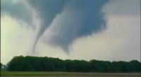
Friend of mine took this pic about 30 minutes ago just west of German Valley, Illinois. -
2022 Short/Medium Range Severe Weather Discussion
vortex replied to Chicago Storm's topic in Lakes/Ohio Valley
Took this about 35 minutes ago. -
Blowing and drifting pretty bad in the country.
-
Any idea how much you have now? Tough to measure by me because of the drifting.
-
Just over 5 some inches here so far. Lots of blowing and drifting. Should get in on southern end of death band shortly. Though less snow, this storm seemed more enjoyable than GHDIII.
-
Was thinking the same thing. lol.
