

Gravity Wave
-
Posts
1,150 -
Joined
-
Last visited
Content Type
Profiles
Blogs
Forums
American Weather
Media Demo
Store
Gallery
Posts posted by Gravity Wave
-
-
-
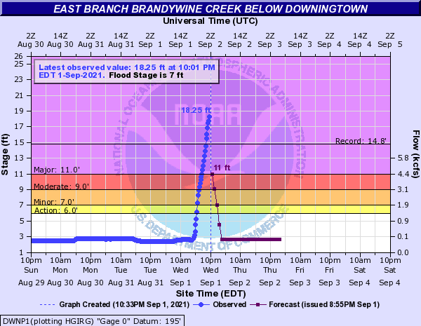
Historic flooding in SEPA, still pouring there:

-
 1
1
-
-
Thinking ahead to January when we'll be begging for 0.5" of QPF from a storm.
-
4
-
 3
3
-
 1
1
-
-
1 minute ago, Stormlover74 said:
JFC
-
1
-
-
Just now, chrisNJ said:
water coming into basement windows. Never before. This is serious folks.
Ground is completely saturated, water has nowhere else to go.
-
3 minutes ago, Tatamy said:
Not in the same league- at least in the Philly area.
Labor Day 1998 and the May 31 - June 2 dual outbreaks earlier that year largely avoided the Philly area apart from some straight line winds from the edge of the derecho. IDK about 1989.
-
 1
1
-
-
Then there's this, the forward speed is extremely impressive.
-
3
-
1
-
-
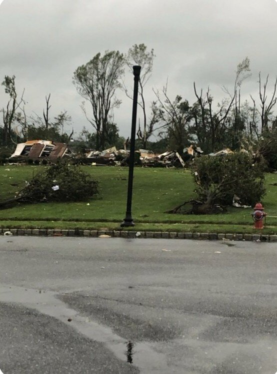
Wild damage photos from the Philly area. EF-4 rating seems possible based on this. Look at the uprooted bush in the foreground!
-
 1
1
-
2
-
-
Dumping here, water is pouring off of my upstairs neighbor's balcony, running down the underside to the top of my living room window, and dripping onto my interior windowsill.

-
Pouring outside here, large puddles forming on 2nd Ave.
-
9 minutes ago, Rjay said:
This summer during that NJ outbreak.
Yeah, the New Hope - Lambertville tornado that fortunately didn't touch down until it had mostly passed the town.
-
1 hour ago, LibertyBell said:
That's an interesting region for that to happen....Don, think that corrects further north where the higher peaks are? I'm thinking from around Hazleton to Mt Pocono.
The hills south of Allentown top out between 800-1000', compared to the 250-350' elevation of the valley below. They aren't insignificant.
-
1 minute ago, Floydbuster said:
Someone asked yesterday why these storms as of late (Michael, Laura, now Ida) seem to deepen towards landfall whereas so many in the past weakened. The answer seems to be storms that wait until the last day to get their act together. Had Ida strengthened into a Cat 4 by Cuba, no way would it have maintained it for a straight 48 hrs without inner core changes and fluctuations.
The struggles that it had getting its act together earlier today may also have increased landfall intensity by delaying an ERC. We saw this with Michael where there were some signs of a secondary eyewall just beginning to form at landfall after the storm had slowly and unimpressively strengthened before bombing in the last 18 hours. Of course, this is just speculation.
-
6
-
-
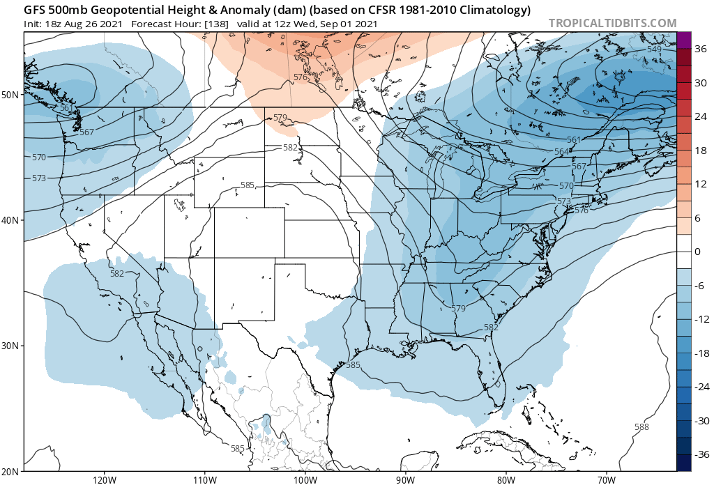
Notable East shift on 00z HWRF vs 18Z.
-
1 minute ago, hlcater said:
Mesovorts present in the eyewall. We are losing pressure and fast.

Shades of Laura and Michael.
-
4 minutes ago, Kevin Reilly said:
Well we know this is too weak considering we are down to 954 mb
Ignore the strength with the globals at this point, what matters is the track. That shows the right eyewall almost over NO.
-
1
-
2
-
-
2 minutes ago, Amped said:
It's closely following Laura's intensity VS time curve.
IIRC Laura also really blew up the evening before its landfall after taking its time getting organized for most of that day.
-
3 minutes ago, pazzo83 said:
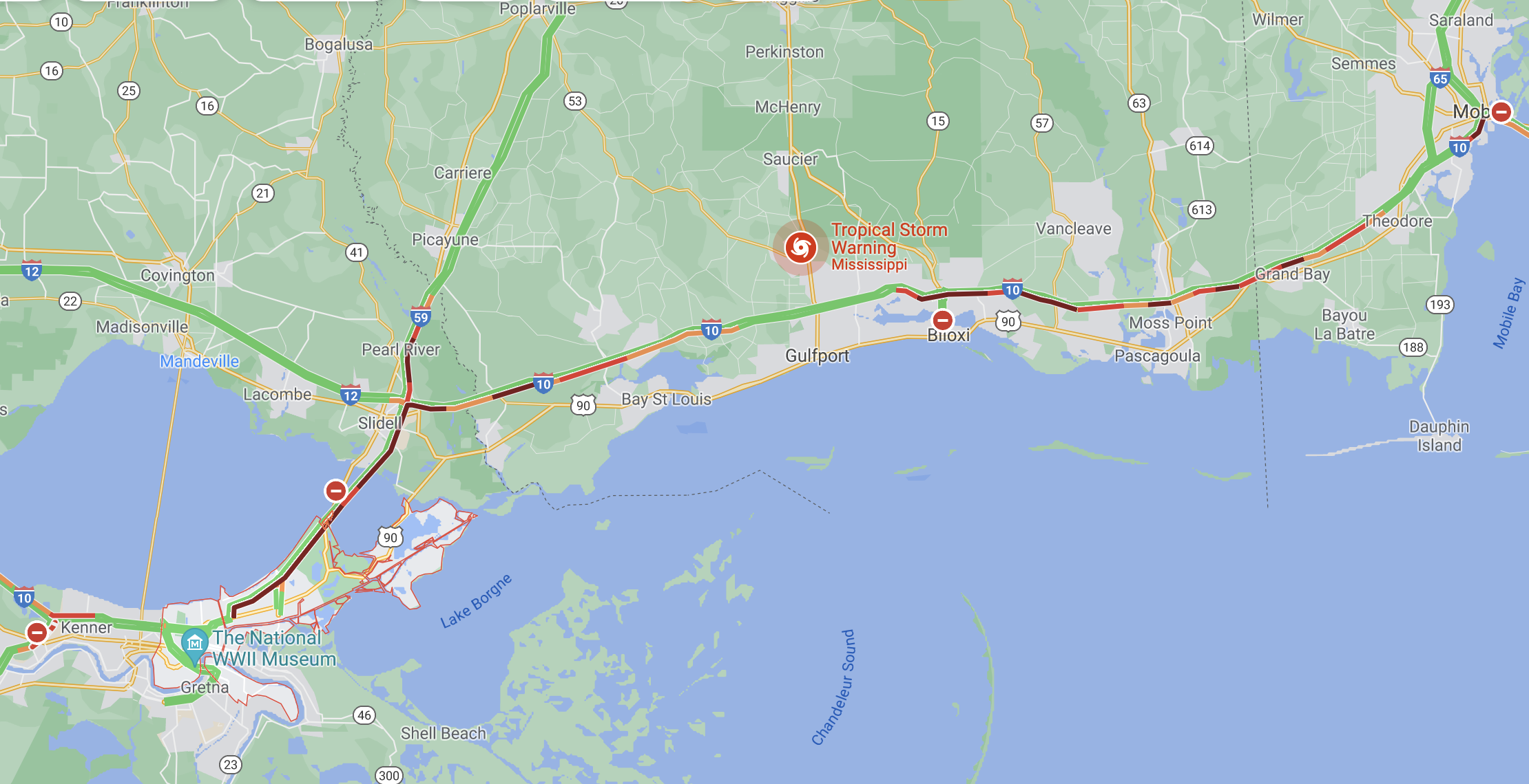
some folks are posting that traffic is backed up on I-10 from NOLA to freaking Mobile, AL. Not great.
Looks like it.

-
People are understandably focused on the potential landfall impacts but the deepening trough in the East being forecast for midweek could cause some major flooding problems in areas that got hit hard by rains from Fred and Henri.

-
2
-
1
-
-
9 minutes ago, Big Jims Videos said:
Lee came through before Irene which also led to historic flooding in NEPA.
Lee was the worst flooding for NEPA, Central PA and the Southern tier of NY since Agnes in 1972.
-
1
-
-
NNJ river forecasts busting way low.
-
3
-
-
13 minutes ago, nycsnow said:
Radar filling back in all of Staten Island is now raining again
Manhattan as well.
-
1
-
-
The models struggled with this storm up to the last minute with virtually every aspect other than timing.
-
1
-
-
Getting some thunder and lightning with this initial band coming off the ocean.
-
1
-
IDA remnants OBS-nowcasts (storm total rain and/or unusual flooding, wind damage-power outage, gusts ~45+ MPH) Wed-Thu morning Sept 1-2, 2021
in New York City Metro
Posted