

Gravity Wave
-
Posts
1,151 -
Joined
-
Last visited
Content Type
Profiles
Blogs
Forums
American Weather
Media Demo
Store
Gallery
Posts posted by Gravity Wave
-
-
Frequent lightning and loud cracks of thunder, probably be the best storm from that perspective in the 3 years I've been here.
-
Heavy rain and some thunder and lightning from the lead cell here in Manhattan, the main show should be interesting.
-
16 minutes ago, bluewave said:
GFS joining the Euro and EPS on potential record breaking heat from the Plains to the East Coast next week.

Let's hope this is as accurate as 9 day temp forecasts usually are.
-
 1
1
-
-
Wow, that storm over the Bronx just exploded out of nowhere.
-
Heavy rain with some thunder and lightning here. Very dark.
-
Is Manhattan going to see hail for the second time in a week?
-
9 minutes ago, bluewave said:
Pretty big dew point spread between the North Shore and South Shore.
LaGuardia Arpt MOSUNNY 94 46
Wantagh N/A 82 72
It's been so muggy the last few summers that I had forgotten what mid 90s felt like with low humidity. Not as bad as i remembered!
-
Pea sized hail here.
-
1
-
-
Couple rumbles of thunder here and some rain beginning to fall (moved to the UES).
-
Back in the old days of the 3-tier severe system our best days always seemed to come with slight risks while moderate risks usually disappointed. So far I'm struggling to remember an enhanced day that lived up to its billing around here either.
-
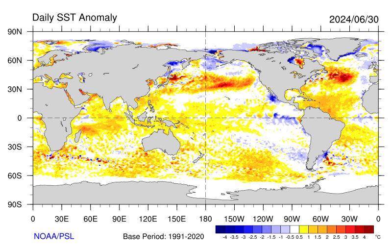
https://psl.noaa.gov/map/clim/sst.shtml
These negative SST anomalies will likely grow through the first half of May, might put a damper on any early season heat.
-
No 70s in Newark in April after a historically warm winter is honestly one of the most shocking temp statistics I can remember for this area, and that's saying a lot.
-
Had 2 decent lines of storms move through earlier (I'm back in the Lehigh Valley atm). Pretty impressive winds continuing here now even as the sky is clearing.
-
While we're all trapped inside, and with the weather looking boring for the foreseeable future, I figured I would post this survey. Basically, it's a list of hypothetical weather events that you're going to rank in order from the one you'd most want to experience to the one you definitely don't want to experience. Here's the list of 15 events to rank, in no particular order.
- An EF-2 tornado (wouldn't directly damage your property, but would pass nearby so that you could clearly see it)
- Golfball/Hen egg-sized hail (1.75-2")
- A severe thunderstorm (funnel cloud, 70 mph winds, quarter sized hail)
- A Derecho (similar in intensity to the 1998 labor day derecho)
- A 12" snowstorm with blizzard conditions (basically a 1/4/18 rerun with slightly higher totals)
- A 20" snowstorm but without any wind and with marginal temps (basically a 2/10/10 rerun)
- A gravity wave that drops 4" of snow in an hour with a complete whiteout for the entire period.
- An ice storm with 4" of sleet and 1/2" of freezing rain
- A dry heat wave with three days of temps between 100 and 105 and low humidity and dews.
- A humid heat wave with three days of temps between 95 and 100 and 70-75 degree dews.
- A cold snap with three days of sub-zero lows and highs around 10 degrees, plus a light breeze at times.
- A category 2 hurricane landfall in NJ/LI that then tracks over your house (not an extratropical storm like Sandy).
- A powerful nor'easter similar to the Ash Wednesday storm of 1962, no snow (https://en.wikipedia.org/wiki/Ash_Wednesday_Storm_of_1962)
- A historic river flooding event with perhaps 2-3 significant rainstorms or one major tropical remnant (like Lee in 2011)
- A flash flooding event with 6 inches of rain in 8 hours
Here is my ranking:
1) 20" Snowstorm
2) Derecho
3) 12" Snowstorm
4) Hurricane
5) Gravity Wave
6) Severe Thunderstorm
7) Ice Storm
8) Flash Flooding Event
9) Nor'easter
10) Tornado
11) Cold Snap
12) River Flooding Event
13) Large hail
14) Dry heat wave
15) Humid heat wave
-
Don't look now but it looks like we're getting our -AO and big time blocking just in time to ruin spring.
-
 1
1
-
 2
2
-
-
1 hour ago, LibertyBell said:
summer of 2010 was definitely my favorite..... hot and low humidity but active severe weather season in the fall...... 2009 through 2016 might have been my favorite time period of weather excluding the winter of 2011-12 of course.
Great winters in that stretch but some of those summers were absolutely awful. Although Dewsaster 2018 can compete with any of those.
As for Floyd, that was the second weather event I remember from growing up after the 1998 Labor Day derecho. The small lake next to my elementary school tripled in size and merged with a nearby creek to force the only rain-induced early dismissal of my school career.

-
38 minutes ago, LibertyBell said:
see summer of 1995 for Chicago.... hundreds of people died, temps hit 106 on back to back days.... and remember all the wild fires here? 0 rainfall for August after hitting 103 in July with a 130 heat index at LGA in late July.
The dew point numbers from Wisconsin during that heat wave were just disgusting. I would prefer to have a summer of 2009 rerun.
-
The GEFS (which is still run off the old GFS core) does actually give a little support.


-
-
The way this winter has gone with all the day 8-10 threats that fell apart a surprise March snowstorm that only started showing up 5-6 days out actually makes sense.
-
2
-
-
Wind just starting to pick up in Midtown.
-
1 hour ago, Snow88 said:
I agree but yet there are some people who will continue to post runs past 300 hours. Like I said , models shouldnt go past 150 hours.
I agree that surface reflections are generally terrible outside of 150 but I think the models are generally better from a temperature and pattern perspective and still have some value until at least 200 hours.
-
16 minutes ago, HeadInTheClouds said:
It's been consistent in showing a system for the fish. The 06z was only run to show a hit.
There were other runs as well. At any rate, you don't want to be getting hits every time at this range, things are going to change.
-
1
-
-
3 minutes ago, HeadInTheClouds said:
To add insult to injury 12z GFS takes low on the 7th OTS although obviously its way to early to be looking at that. In general I think GFS is a lousy model and they should limit it to 240 hours like the rest. What is the point of going out farther on an operational?
The GFS has been consistent in showing a big system for then, and the airmass looks a lot better than the one forecast for the 1st.


Tropical connection NYC forum area Sun-Wed, 8/2-5/20- Tropical Storm Isaias
in New York City Metro
Posted
The Delaware and Lehigh Valleys and the Poconos got slammed as well. Up to 20" of rain in parts of NEPA with Diane. The river flooding was historic but the flash flooding on the smaller tributaries was even worse.