

Gravity Wave
-
Posts
1,151 -
Joined
-
Last visited
Content Type
Profiles
Blogs
Forums
American Weather
Media Demo
Store
Gallery
Posts posted by Gravity Wave
-
-
Just now, Blizzardo said:
Subsidence has nothing to do with the northern cutoff. Thats a whole nother story and can also happen anywhere
Subsidence can indeed happen anywhere, but that includes the areas north and west of the main deform band which can sometimes accentuate the northern/western cutoff, a la January 2016 and BDB.
-
1 minute ago, NJwx85 said:
The gradient is going to be sharper than what the models indicate. Cannot tell you how many times recently that I was on the fringe and got absolutely nothing.
You always have to take this account if you're near the northern or western fringe with big, dynamic storms. Sometimes everything works out, but the subsidence from the deform band is rarely handled well, even by many of the mesos.
-
Wouldn't take much of a shift to put the city on the core of the deform band. The mesos will be key starting tomorrow.
-
Euro is clearly improved, although it still tries to hold the heaviest precip back across PA. Not a huge deal given its low resolution.
-
Ukie has consistently had the least impressive jackpot totals. I wonder if that's a function of the snow depth maps, because it certainly isn't spitting out less QPF than the other models.
-
If I had to pick a way this goes wrong for the City I think it would be in the form of the GFS (heavy precip going south of the area) rather than the NAM (mixing issues and deform band well to the north), but I think we're in an excellent spot right now.
-
The Euro and CMC closed off the system on Friday IIRC, interesting to see that potential re-emerge.
-
 1
1
-
-
17 minutes ago, Big Jims Videos said:
I lived in Luzerne County during the early 2010s and remember many a storm giving NJ the snow and we smoked cirrus. Why would the gfs be right? What effect is the monster 950 low having on the high? I watched like 3/4 storms in a row blast southeast of Scranton/Wilkes Barre.
2009-2010 had several storm that did that, December 18-19, February 5-6 and February 10-11 all had brutal northern cutoffs, although the cutoff line moved north each time.
-
1
-
-
If the final solution splits the difference between the GFS, Euro and CMC then the City should do extremely well.
-
Nothing to see here, just the UKIE dropping 2" of liquid equivalent for the City and the coast:

-
1
-
 1
1
-
-
1 minute ago, Ericjcrash said:
Being this far north, I can dig the lean. Airmass being so cold so can the coast.
The source airmass is fantastic, most of SE Canada is below 0 degrees at the height of the storm. If we can get this to close off and deepen a la CMC, hence drawing in even more of that cold air, we could get an incredible result.
-
1
-
-
GEFS has improved from 0z. Remember the 2 camps I talked about? The eastern, weaker, progressive camp has shrunk significantly and is now a small minority while the stronger, west, amped camp has grown:

The great high in Canada is preventing the amped solution from being too warm for the City and much of the coast.
-
GEFS is split into 2 camps: the cold, weaker, progressive camp of the OP and the warmer (for coastal areas) amped bomb camp of the CMC/Euro, with the latter group being larger. Could be the difference between an SECS for I-95 and the coast and a glancing blow for the interior on one hand and an MECS for the interior and a mixed bag on the coast with I-95 on a knife's edge. Hopefully the confluence continues to build which could allow colder solutions for marginal areas even in the case of an amped system.
Edit: Here are the GEFS snowmaps. Some great hits in here:

-
 2
2
-
-
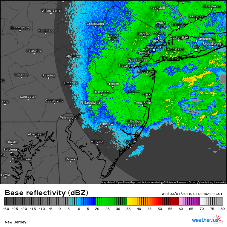
The March 7, 2018 nor'easter (the first of that month's trio) is an underrated bust for NYC proper, IMO. WSW upgraded to 8-12" for the City the morning of the event, short range models going bonkers, the first wave of snow comes in like a wall... and then the tap just shuts off around noon. IIRC the storm got tucked a little closer to the coast than expected and the CCB tracked west across the city and set up over NNJ, resulting in on-and-off light to borderline moderate snow for the rest of the day. This radar shot from 1:30 that afternoon is pretty representative of most of the event, note the subsidence over the city from the NNJ band and the developing bands over the ocean that would briefly increase snowfall rates before merging with the main band:
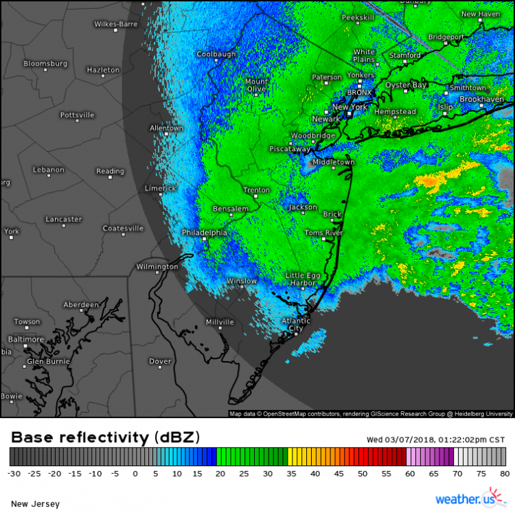
The low rates we got for most of the afternoon just couldn't overcome the marginal boundary temps, which hovered around 34 as soon as the dynamic cooling from the CCB ended. The mini garden in front of my building in Chelsea ended up with 1.5-2" of slush but when I left my office in Midtown you would never have known it had been snowing most of the day. Meanwhile NNJ and the LHV got crushed.
Definitely the worst bust since I moved here in 2017, at least. Behold the suck:
-
1
-
-
2 minutes ago, Stormlover74 said:
Once the euro was on its own it was clear it was going to bust
I remember before other models started catching on the GGEM was the progressive/east outlier and thinking that was a red flag since it's usually the opposite. Still, the Euro/NAM combo was seen as unbeatable then.
-
3 hours ago, jm1220 said:
From Queens/Nassau east I wouldn’t classify that as a miss. Nassau had 12” at the Queens border to 18” at the Suffolk border and 20+ east of Rt 112 just about. Long Beach had 15”. Of course I was living in TX at the time and missed this as well as the monster Jan 2016 storm.

IIRC there was a secondary band that set up over Nassau and far eastern Queens that helped limit the damage in those areas to "regular bust" rather than "historic forecasting disaster" like it was for the rest of the City, NENJ, LHV and western CT. I was living upstate at the time but vividly remember the insane runs and the shock of realizing what was actually happening.
-
4 hours ago, MJO812 said:
Lets get that ULL further east depicted on the gfs and let the games begin. Pattern should become more favorable as we get into December. Hopefully we can cash in.
Last December storm was terrible here in the city .
The last storm that was good at all in the city was March 21, 2018, or January 4, 2018 depending on how you feel about temps.
-
My parents are driving to Pittsburgh today and reported 81 degrees in Altoona. Crazy stuff.
-
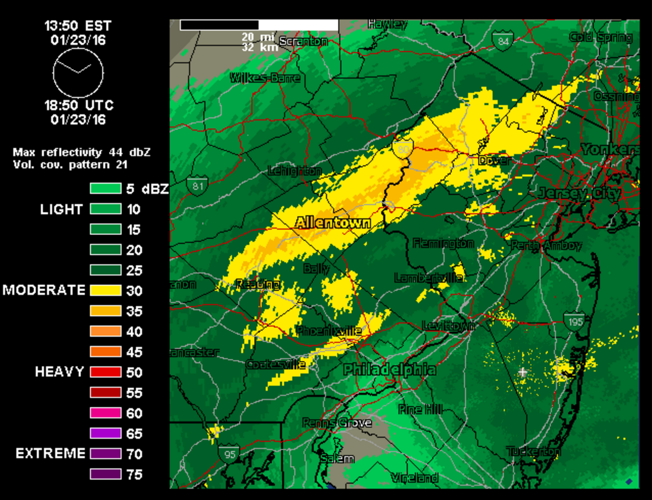
BDB was for me what January 2015 was for most people on this forum, albeit a slightly smaller bust. I was home in Allentown from my freshman year of college and had given up on the storm until the Christmas eve model runs pulled me back in. The modeled gradient on the western side of the storm was fairly sharp but no models consistently had far eastern PA out of the 6-10" range, and some were higher. We got a WSW for 10-16", IIRC the NWS was aggressive because the storm was overperforming to the south. Of course, the storm deepened more quickly and profoundly than expected, and the heavy banding hit a wall around I-287. With this result:
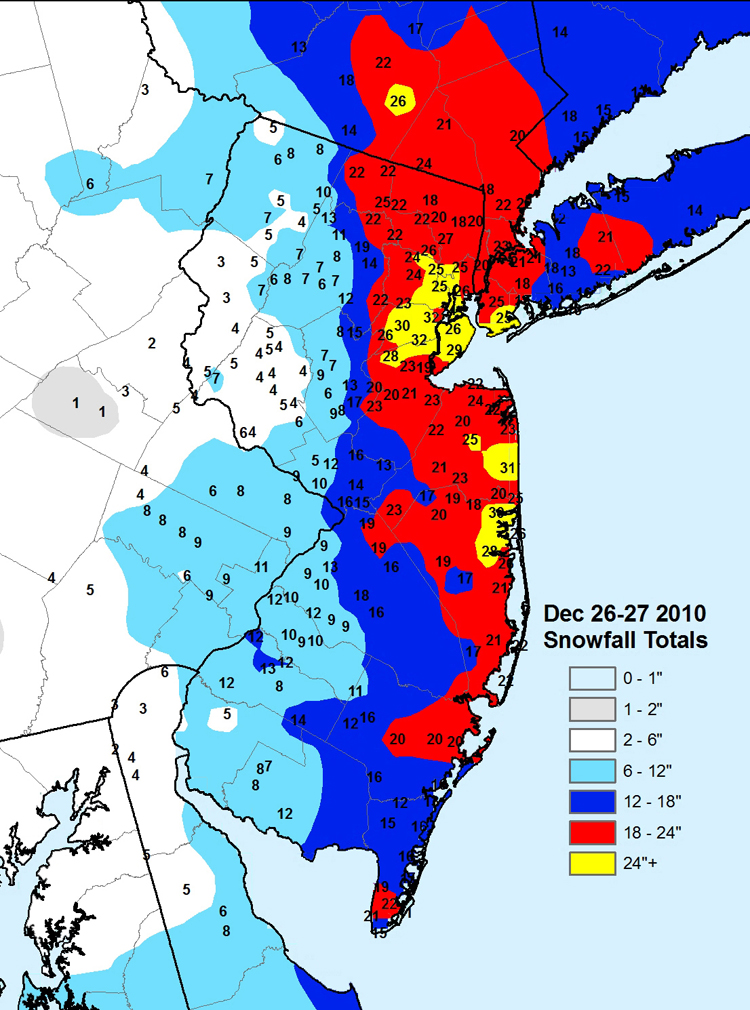
2" of pixie dust and the most painful radar images of my life, at least until I watched the Blizzard of 2016 drop 30 inches of snow at my house from cloudy Ithaca 36 hours after leaving home for spring semester.
-
2
-
1
-
-
1 hour ago, lee59 said:
Looks like the first week of September will have temps up and down to average about normal. Looks like the second week may bring in a more consistent cool down making the first have of the month a little below normal. Wouldn't that be a change if it plays out.
It would be amazing to have a September that felt more like September than August for once.
-
1
-
-
I'm glad the rain is staying south, any missed weekend night for outdoor dining is devastating for a lot of restaurants.
-
Loud thunder here as the rain begins.
-
These power outages are the first things that are making me happy to be in the city since March.
-
1
-
-
Heavy rain on the UES, it began very suddenly.
Major Nor'easter snow storm (possible top 20) Noon Wednesday-Noon Thursday Dec 16-17, 2020
in New York City Metro
Posted
Surface is nice and cold on the NAM, but 850s get close to zero for the I-78 corridor east to the City early in the storm. Something to watch on meso models.