

Gravity Wave
-
Posts
1,165 -
Joined
-
Last visited
Content Type
Profiles
Blogs
Forums
American Weather
Media Demo
Store
Gallery
Posts posted by Gravity Wave
-
-
1 hour ago, LibertyBell said:
You missed some of our best years by just a few. A 30 inch blizzard in January 2016 and an incredible period from March 2018 to April 2018 when we had 5 snowstorms!
That March--April 2018 period wasn't particularly amazing in the City proper. 3 of those storms were white rain, at least in Manhattan.
-
 1
1
-
-
5 minutes ago, bluewave said:
At least we haven’t had any major ice storms recently which were more common from the 70s into early 90s. The last more significant ones I remember from LB were February 07 and 11. But nothing like the ice storms in Jan 78 and 94.
Ice storms seems to have joined Alberta Clippers as weather events that no longer seem to play a major role in our winters. I remember getting 5 inches of sleet topped with a glaze of ZR in December 2008 growing up in Allentown, less than 2 years after the epic Valentines Day ice storm in February 2007 that stranded hundreds of drivers on I-78.
-
2
-
-
1 hour ago, Franklin0529 said:
The AI been rock steady
The AIFS has basically been locked in since 5 days out, with just some slight NW adjustments as the storm approached. Once it starts showing a solution consistently in the mid range it seems pretty deadly.
-
2
-
-
3 hours ago, Snowstorms said:
Off topic, but is NYC worth visiting pre Christmas or is that all just movie/social media hype? And why are hotels in Manhattan so expensive rn.
If you don't like crowds then you can come visit in the first two weeks of January. The tree and a lot of the Christmas stuff is still up and there are far fewer people. Plus the weather is usually more wintry.
-
1
-
 1
1
-
-
3 hours ago, EastonSN+ said:
For fond November memories... Will be in the city for Thanksgiving would have much preferred better weather.

One of the all-time commuting nightmares given that the City was expected to quickly change to rain and almost no one stayed home. Sadly turned out to be the peak of that winter...
-
4
-
-
1 hour ago, SRRTA22 said:
I smell the wildfire now in Manhattan, strongest smoke smell since 2023
I've been smelling it for over an hour here.
-
Heavy rain and lightning in Manhattan.
-
1
-
-
1 hour ago, MANDA said:
Can you imagine if a "Connie and Diane" scenario unfolded today !?
The region was in the midst of a drought when Connie and Diane hit; if it happened again today it's unlikely we would have such luck.
-
If anything things are getting started faster than expected compared to the HRRR.
-
3 minutes ago, hooralph said:
Forgive me if this was shared previously; relevant to the CPK discussion and the summer in general. Very localized heat island map.
I was gratified to find I live by that “cooler” tongue on the UWS; I suspect the streets (esp the wide ones : 106 and 110) providing more of a channel for upsloping winds.https://www.thecity.nyc/2023/07/26/heat-island-hot-map-temperature/

I assume that these departures are specific to the summer given how the sun roasts everything? It would be interesting to see the winter version.
-
1
-
-
Sun has come out ahead of the storms in Manhattan.
-
If it's going to be hot then let it be dry as well. I'm not trying to spend $350 cooling my apartment this month.
-
1
-
-
6 hours ago, bluewave said:
The Euro seasonal just updated about an hour ago and is going wet this summer with plenty of tropical moisture input. So it looks like a warm and wet pattern rather than dry heat. Onshore flow and higher dewpoints with a drought feedback ridge near the Rockies and ridge near the Northeast. With very active tropical cyclone tracks undercutting the ridge.


Feels like people have been honking about the threat for a significant east coast (north of FL) hurricane strike for several years now but it hasn't happened, and I don't think the issue has been the failure of the expected Atlantic patterns to materialize. Have we just been lucky?
-
It's funny to see people complain about a lack of heat in May when we're basically guaranteed 10 weeks of disgusting tropical weather every summer. Meanwhile those of us who enjoy the cold have to pray for a 3-day arctic blast or two to break up the 4 months of eternal November every winter.
-
6
-
 1
1
-
-
2 minutes ago, LibertyBell said:
That was a mediocre storm for us just east of the city. The park got 26" and we got 13" we were in subsidence hell. I don't consider that an HECS because the 20"+ accumulation area was so darn small. The park total for that storm was higher than my total for the entire season. We also had that storm in December that gave the park 6" and we got nothing but rain-- thats the first time thats ever happened. My most exciting storm that year was the 2" we got in April when the park got 0.1" to hit 40" for the 4th straight year.
January 2016 was so much better than that storm and a true HECS (and the third best KU event behind March 1993 and January 1996 overall.)
Wasn't here for that storm but I've heard a lot of people who were saying that they couldn't believe that CPK amount because they got so much less. I don't actually have any memory of it despite Allentown apparently getting 10-12", but I agree it's nowhere near the level of the all-timers despite its gaudy position on the snowfall list.
-
1
-
-
Lack of consistent heavy rates plus the bad boundary layer (and warm pre-storm conditions) killed the storm in Manhattan. Very reminiscent of 3/7/18 where it snowed all day but the deform band ended up over NNJ instead of the City where it was modeled to be and the torched boundary layer never never got the full dynamic cooling effect so we had 33-34 degree white rain. Wound up with a coating of slush in Midtown and little more in Chelsea.
-
2
-
-
Coating on cold surfaces here, starting to stick to the Avenues.
-
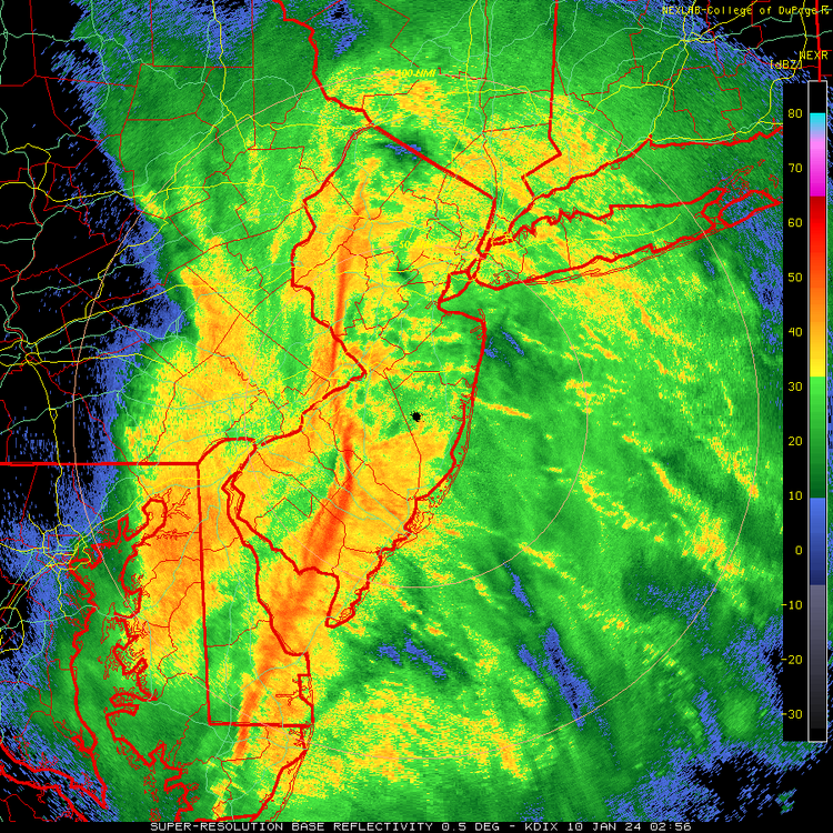
That embedded squall line feature looks nasty.
-
3
-
-
51 minutes ago, jm1220 said:
12” of snow in Central NJ from one storm is still a ton. We’ve been spoiled since the early 2000s. I remember the late 90s were horrendous. Between April 1996 and 12/30/00 couldn’t get any event more than a few inches. Don’t want to disturb the hornet nest but we’re due for a down period again. Hopefully this winter can produce but the background Niña state and -PDO is always a concern.
We've pretty much been in a down period since March 2018, with the exception of February 2021 (and maybe January 2022 for eastern areas).
-
6 hours ago, bluewave said:
The 80s were known for the big 3. Historic April 82 blizzard that still stands as our greatest late season blizzard. The famous February 83 snowstorm. Then the surprise January 87 snowstorm that was supposed to quickly change to rain but dropped near 10” on Long Island. You could also add the surprise December 88 Norlun that dropped around 10” on Long Island. But the snow band was so narrow that Western Suffolk had close to 12” and Long Beach got nothing. So it was too limited in coverage for me to add to my big 3 list.
Growing up in Allentown the neighbors who had been around for a while would talk about February 1983 before 1996 even though the latter ended up as a slightly bigger storm in terms of accumulations (30" vs 25"). I think it was the intensity that made such an impression, 1996 was 36 hours of steady snow while 83 came in like a wall and dropped 5" in an hour at one point.
-
November 2019 also had a historic arctic outbreak in mid-month. I forget how much it moderated by Thanksgiving.
-
4 minutes ago, Allsnow said:
All the storms in 2010 would have been white rain in todays climate
The Feb 5 storm probably wouldn't have been had it been able to make it further north.
-
I think we'll take our chances with strong blocking at the risk of some 2/5/10 or 1/13/19 style misses. You'd have to think one storm would get far enough north to slam us.
-
1
-
-
Pouring here again. Visibility down to barely half a mile.
-
1
-


February 2025
in New York City Metro
Posted
Wait, you can bet on NYC snowfall? A few seasons years of putting the house on the under and I'll be able to retire.