

Gravity Wave
-
Posts
1,150 -
Joined
-
Last visited
Content Type
Profiles
Blogs
Forums
American Weather
Media Demo
Store
Gallery
Posts posted by Gravity Wave
-
-
The last clipper I remember was in January 2010 right after the New Year when I was still in Allentown. Was supposed to be a 2-4" event, ended up with a dusting.
-
 1
1
-
-
I had my AC on last night as well.
-
1
-
-
1 hour ago, Allsnow said:
January 21?
I'd guess that or February 10-11, 2010.
-
1
-
-
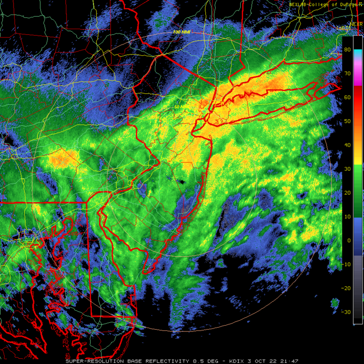
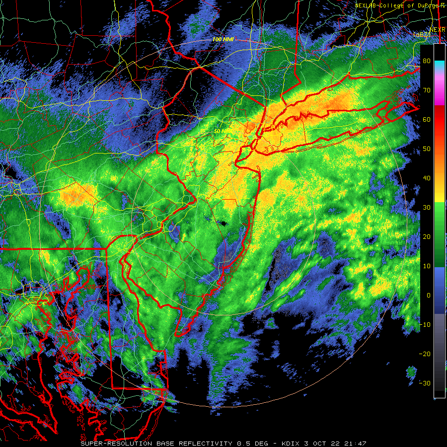
Let's get this exact same radar image in 10 weeks, please.
-
4
-
 1
1
-
 1
1
-
 1
1
-
-
I have to say the big short terms busts on rain events aren't filling me with confidence in the models for the winter.
-
4
-
-
Summer is the worst season by far in NYC, always glad for it to end.
-
7
-
-
Have had some heavy downpours here but not much left per the radar.
-
7 minutes ago, Cfa said:
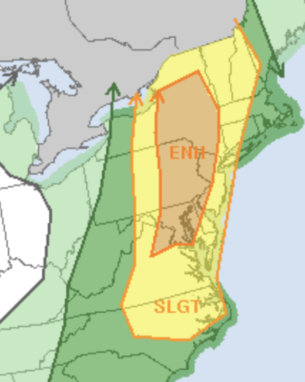
I tend to temper my expectations when we’re under a Slight Risk.
82/77 here. Another 90+ would be nice.
Our best severe outbreaks usually happen under slight risks. I admit this isn't the most favorable setup given the PFT timing.
-
2 hours ago, dWave said:
Heavy rain and intense hail storm in lower Manhattan. Windows getting bombarded with mostly hail. At least at high rise level. I see it bouncing and acclumating on the roofs of shorter buildings.
Interesting, we didn't get any hail up here that I heard.
-
1 hour ago, CIK62 said:
Holiday Weekend: Fr.i/Sat. definitely NG. Sun./Mon. still an open book.
At any rate, the GFS keeps trying to produce a tropical system for the last week's worth of runs and thinks it has it now with this bowling ball, which has just followed a Donna-1960 like path all the way up the EC from Florida:

The entire coast from Cape Hatteras to Cape Cod is overdue for an impactful Hurricane strike (I don't really count Sandy, and definitely don't count Irene). Another stretch like 1938-1955 would be ugly.
-
1
-
-
5 minutes ago, Tatamy said:
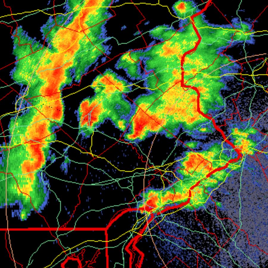
Looks like a hail core with the cell just north of Reading.
A couple nasty looking cells there.

-
1
-
-
Here we go.

-
Looks like some action ahead of the main line in SEPA. What could become our MCS is still west of Harrisburg.
-
The severe indices being forecasted for later in PA are actually quite impressive by this region's standards. 3000 CAPE, -9 LI and EHI 6+ in some places. Lapse rates less noteworthy but still decent.
-
Still time for those trailing storm currently over SEPA to turn into something but it looks like the rule that our best severe events happen during Slight risks is going to hold.
-
1
-
-
8 minutes ago, jr461 said:
Been using this mostly but not as good IMO:
The regional on WU still works but you have to really zoom in:
That's the site I use, here's the link for the Fort Dix radar:
https://weather.cod.edu/satrad/nexrad/index.php?parms=DIX-N0Q-0-6-100-usa-rad
-
2
-
-
Pop-up thundershower in Manhattan just now.
-
1
-
-
Day 2 Enhanced!
-
43 minutes ago, Tatamy said:
There was no snow squall warning in effect for Schuylkill Cty at the time of the terrible multiple vehicle crash on I81 on Monday morning. Due to the distance between the radar stations situated in this region weather radars cannot see below 9000 feet in that location. The squall was low topped so it was underneath the radar beam. A similar scenario played out in February in that area of PA. I was out in the Scranton region on that day (I drove south on I81 and then onto I476 to the south of there. Elevations range up 2000 ft in that vicinity. The roads had been brined or were dry. Temperatures ranged from 21 to 25 depending on altitude. Penndot had signage posted on the electronic equipment about the potential snow squall hazard. I encountered snow flurries and showers on my drive. This squall that caused the accident was apparently in a narrow streamer that reached SE down to the Philadelphia area. This has been a recurring problem in east central PA and I hope they decide to increase radar coverage in that area.
I remember tracking storms growing up in eastern PA and dealing with a lack of good radar data once they crossed the Susquehanna until they were almost on top of us in the Lehigh Valley, especially if they were approaching from the NW. It's an underrated radar hole, especially when you consider that the areas impacted are quite populated and growing rapidly.
-
1
-
-
3 minutes ago, dmillz25 said:
We have 12” here in bed stuy Brooklyn
Yeah you got a little more banding than we did overnight. The final gradient between NENJ/the LHV and eastern Queens/Nassau is going to be dramatic.
-
1
-
-
2 minutes ago, HVSnowLover said:
Upton did really well with holding their ground with the 7-11 for NYC even with the models going east yesterday. If anything NYC may overperform a little.
Yes, the park has 0.86 LE as of 1:00 so probably 10" there, I'd say we have 8-9" on the East side (due to losing more from melt at the start of the storm). I can't imagine other parts of the city having much less than that.
-
Approaching an inch here, side streets starting to get covered. Snow has gotten appreciably heavier recently, looks like the frontogenesis and banding is getting a little further west than expected.
-
1
-
-
A month of great blocking and we couldn't buy a drop of precip. Now the storm train is rolling and there's an express track from NC out into the Atlantic.
-
1
-
-
Low gets closed off east of the Delmarva Saturday morning. WOW.
-
4
-
December 2022
in New York City Metro
Posted
This website has a ton of info about every winter storm of any significance to strike this region from 1993-2013. The writeups and snow maps are NJ-focused but there are a ton of other resources (radar imagery, surface maps, pressure/temp maps from various levels, regional station observations) for the storms.
Ray's Winter Storm Archive (raymondcmartinjr.com)
As for the millennium storm, I've linked that page below and it seems there was a weak, dying low over Lake Erie that transferred to the NC coast.
Snow storm, December 30, 2000 - Storm Summary (raymondcmartinjr.com)