

Gravity Wave
-
Posts
1,150 -
Joined
-
Last visited
Content Type
Profiles
Blogs
Forums
American Weather
Media Demo
Store
Gallery
Posts posted by Gravity Wave
-
-
As far as I'm concerned there's little downside to a Nino. Either it's a weak or moderate Nino and we have a favorable ENSO state for next winter (finally) or it's a strong Nino and we have a chance of disrupting the stuck patterns that took hold after the 2015-16 super Nino (most of which have been unfavorable to us). Plus, as has been noted, strong Ninos offer a chance of an HECS amidst an otherwise bad winter.
-
 4
4
-
-
2 hours ago, jm1220 said:
Congrats DC is usually good for us too. Other than rare occasions like 2/6/10 which I think was the only occasion NYC recorded a trace and Philly anything like their 24”. There have definitely been lesser NYC screw occasions like in March 2014 that were good events in S NJ and the DC area but the big dogs usually find their way north enough to get to NYC. There are also many Congrats Boston events that are good for us too but shaft anyone west of the Delaware if not worse. That’s why NYC is so tough to forecast for. We’re on the fest vs bust line on any big event. There hasn’t been one huge event I can remember where it’s been “given” that NYC would get slammed more than 72 hours out. The huge Nino events and Blizzard of 96 were given to nail DC, 2/8/13, 1/25/15 were given to nail Boston. Had last Jan’s big storm been just a little better consolidated like Boxing Day 2010 (which gave zero to DC) vs. the mess of convective lows it was, the best snow might’ve been over the NYC area. NYC in all was on the line until eventually we had to fall on one side of the knife.
IIRC NYC seemed to be in the prime spot for February 1, 2021 several days out, the models mostly all had the heaviest snow along an NYC-ABE-MDT axis inside 100 hours. Unfortunately the storm tucked a little more than expected and the heaviest snow ended up west of the City. Still was only 2" away from being an HECS so it definitely counts as a hit.
-
1 minute ago, SnoSki14 said:
Can you imagine that right now. It's been so warm and snowless that I can't even consider that happening.
I think it was more of an HECS for the southern Mid Atlantic, the Jersey shore and Cape Cod than NYC. DC had 20 inches and Cape May had 34!
-
1
-
-
Just now, bluewave said:
We have been getting more frequent winters similar to what is normal from DC to Baltimore. This translates into 40° months during the winter and under 20” of snow. So more of a northern edge subtropical climate for us. Less of the colder winter continental climate that we used to get.
You'd expect DC and Baltimore to warm by about as much though. This seems to be a continuation of the recent theme of the biggest warm departures being north of us, just in the winter rather than the summer.
-
1
-
-
34 minutes ago, bluewave said:
Warmest departures have been further north this winter so Baltimore is running cooler relative to their rankings.

Time Series Summary for Baltimore Area, MD (ThreadEx)
Click column heading to sort ascending, click again to sort descending.RankEnding DateMean Avg Temperature Dec 1 to Feb 7Missing Count1 1932-02-07 46.0 0 2 1890-02-07 44.8 0 3 1950-02-07 43.6 0 4 1933-02-07 41.6 0 5 1937-02-07 41.3 0 6 1949-02-07 41.2 0 7 1913-02-07 40.9 0 8 2020-02-07 40.7 0 - 1947-02-07 40.7 0 - 1880-02-07 40.7 0 9 2012-02-07 40.6 0 10 2016-02-07 40.5 0 11 2002-02-07 40.2 0 12 2023-02-07 40.1 0 - 1924-02-07 40.1 0
Time Series Summary for NY CITY CENTRAL PARK, NY
Click column heading to sort ascending, click again to sort descending.RankEnding DateMean Avg Temperature Dec 1 to Feb 7Missing Count1 2016-02-07 42.8 0 2 1932-02-07 41.5 0 3 2002-02-07 41.4 0 4 2012-02-07 40.5 0 5 2023-02-07 40.0 0 6 1950-02-07 39.8 2 7 1991-02-07 39.6 0 8 2020-02-07 39.3 0 9 1998-02-07 39.1 0 - 1933-02-07 39.1 0 10 1999-02-07 38.9 0
Time Series Summary for Caribou Area, ME (ThreadEx)
Click column heading to sort ascending, click again to sort descending.RankEnding DateMean Avg Temperature Dec 1 to Feb 7Missing Count1 2016-02-07 23.1 0 2 2021-02-07 22.7 0 3 2023-02-07 20.6 0 4 1958-02-07 19.4 0 5 2006-02-07 19.2 0 - 2002-02-07 19.2 0 6 2011-02-07 18.9 0 7 2020-02-07 18.6 0 8 1983-02-07 18.4 0 9 2010-02-07 18.2 0 10 1997-02-07 18.1 0 Forget the exact temps, if you told me we'd only be running 0.1 degree colder than Baltimore for the winter I could've pretty much guaranteed a bad winter.
-
1
-
-
1 hour ago, Stormlover74 said:
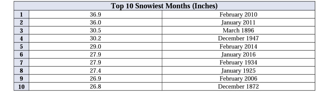
Central Park got 20" for the snowicane storm. It's also their all time snowiest month despite nothing from the 5th-6th storm
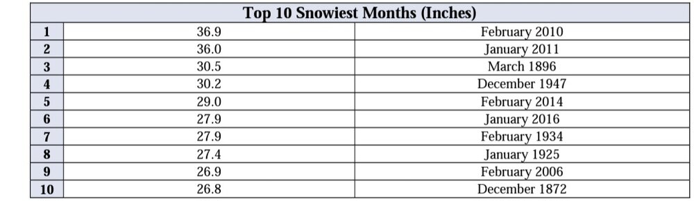
That's because they also got hit hard by the February 10 storm, which seems to be largely forgotten today despite being the most impressive event I've ever personally experienced (too young to remember 1996 and was in upstate NY for 2016). We got 18" of snow (after compaction, which was likely significant because the temp was 32 degrees for the whole storm) IMBY in Allentown in about 5 hours. It saved the winter for me since we got skunked by 12/19, 2/6 and Snowicane that year. I still wonder what would have happened if we'd had a better airmass for that storm or if it hadn't been in such a hurry to leave.
-
Would be great if the Nino could break some of the stuck patterns of the last 6-7 years (endless SE ridge, NW Atlantic warm pool, eastern Pacific cold pool).
-
Looks like a potential chance at D10, which corresponds with a trough swinging through the east that the ensembles are now showing.


-
2
-
-
4 minutes ago, binbisso said:
The rgem can be warm at times. Like today. It's snowing already here in Lower Westchester and the rgem up to 12z today had me as all rain. Maybe it will be right for Wednesday but it is wrong today
RGEM and CMC have a warm/amped bias. If they're the only models showing an event as all rain, you shouldn't be too worried.
-
Loud thunder in Manhattan, and now heavy rain.
-
There is a coastal signal for the 31st on the 12z GEFS, although it appears to be too warm for the coast. This is the next threat after the 25th-26th, and possibly the only one that will occur during our brief "improved" pattern.
-
The 25th/26th threat is very close for the coast according to the Euro. Every small shift south with the 1st storm, even if it's going to be a rainer for NYC, will help our cause for the second one.
-
2
-
-
Euro has a bomb at D9, looks good for the coast. Could this be our season saver?

-
2
-
-
5 minutes ago, vegan_edible said:
lets see what the 18z GFS has in store for those 2 systems. I have heard that the 6z and 18z aren't as accurate due to not accounting for certain upper level dynamics but that could be total BS. someone who knows more than me (literally anyone on this forum) please inform me. I feel like a lost puppy reading some of these scientific replies but I love it
I don't think that's really true anymore. What I will say is that the 18z and 06z GFS use the same data as the 12z and 00z runs, respectively, so they are a little less interesting for that reason.
-
5 minutes ago, Winterweatherlover said:
Personally I'd prefer it like this, at least I'm not losing sleep staying up for the Euro for rain events. I don't know if the models are getting better or the pattern is just so horrible that they haven't even been able to tease much this winter. That's why I'm curious what happens with the storm Thu-Fri to see if the models still show something interesting inside 144 hours.
There's definitely less heartbreak like this, but in a way it's almost more psychically damaging. At least in a near miss situation you can tell yourself that you just need one or two more things to work out the next time, in the pattern we've had there isn't even room for any wishful thinking.
-
I don't think we've had a single meaningful threat survive to the D7 mark (168 hours) this year. The Christmas bomb was clearly cutting by that point and today's threat was a goner after a few interesting runs last week.
-
3
-
-
21 minutes ago, vegan_edible said:
I refuse to give up hope on this winter, but my very primitive knowledge of weather I've gained in the past month has taught me this
the GFS was made to get my hopes up
the ECMWF was made to shatter my dreamsBack when the Euro was the undisputed King, people called it Dr. No because it would almost always shoot down whatever fantasies the GFS, NAM and Canadian would spit out, and all but the biggest weenies would take it to the bank. But on the rare occasions when it did show something big inside 5 or 6 days, you knew it was time to get excited. All of that died after January 2015 of course, and since then no model has come close to getting that level of respect (at least for forecasting east coast winter storms).
-
4
-
 1
1
-
-
7 minutes ago, jm1220 said:
The 222hr/282hr/312hr metro area is having a blockbuster winter this year. My future virtual ruler and future virtual snowblower are all set!
Actually we haven't even had much fantasy eye candy this year, which contrasts with our other recent bad winters where we've frequently been teased.
-
3
-
-
The late January pattern change doesn't appear to be getting pushed back yet on the models. Does anyone think that the relatively Nino-like attributes of the current pattern make a typical (i.e. bad) Nina February less likely?
-
In Pittsburgh for Christmas, really crazy conditions out here. -5 in the middle of the afternoon with 50 mph gusts, absolutely wild and incredibly cold. Near whiteout-conditions on the turnpike from blowing snow, and that was from just a few inches of accumulation. Some stations in the northern part of the state hit blizzard conditions.
-
1
-
-
Don't look now but the ICON is taking a significant step towards the GFS with its handling of the shortwave through 75...
-
2
-
 1
1
-
-
16 minutes ago, Winterweatherlover said:
I actually think this December has been better than some recent past ones. A lot of northern and western parts of this subforum have already seen 3 snow events. The snow did make it into NYC and the immediate suburbs last Sunday. I can't remember the last winter it snowed much in or near NYC before Christmas.
NYC proper got 6-8" from a storm in mid-December 2020.
-
12z CMC has the pre-Christmas threat.

-
2
-
-
Things are definitely heading back in our direction after yesterday's scare. Given how this has developed so far I'm expecting more curveballs.
-
1
-
February 2023
in New York City Metro
Posted
The struggle to reach 70 today just makes the 80 from February 2018 even more impressive. Easily the most incredible temperature event I've personally experienced.