

Gravity Wave
-
Posts
1,150 -
Joined
-
Last visited
Content Type
Profiles
Blogs
Forums
American Weather
Media Demo
Store
Gallery
Posts posted by Gravity Wave
-
-
4 hours ago, Volcanic Winter said:
Seems an uptick not just in tornado frequency but also intensity over this area. I’m aware stronger ones have occurred in the past as well, but the frequency of EF 1 and 2 events seems higher. Most of our tornadoes are EF 0 spinups, sometimes low end / borderline 1’s.
Add the EF3 to my southwest in 2021 and then that EF3 in the Delmarva recently. I still can’t believe the former looked like a legit deep south multi vortex wedge
Definitely seems like an uptick in intensity. I have no data on this and may be incorrect but it also seems like we’re seeing more supercellular storms and not just the typical QLCS with associated spinups.
It definitely feels that way. What's interesting is that most of these stronger recent tornadoes didn't come as part of major severe outbreaks; they were on days where there weren't widespread severe storms. It would be interesting to see what happens if we could get a more large-scale event in the area.
-
 1
1
-
-
3 hours ago, Brian5671 said:
same pattern as the winter-no cold air anywhere
There was plenty of cold in the West.
-
4
-
-
We dry.
-
55 minutes ago, nycwinter said:
i am starting to feel heat exhaustion when will this summer heat end..
Everyone was saying how tired they were of cool springs, well here you go!
-
1
-
-
7 minutes ago, Stormlover74 said:
Imagine a 34 dewpoint in July
I'd settle for anything below 65, that used to be possible during the summer.
-
1
-
-
That 1985 outbreak is one of the most anomalous weather events in US history based on the number and proportion of violent tornadoes versus where it occurred. I've always wondered if something like that could happen 150 miles east of where it did; the recent uptick in severe weather makes me suspect that it might be possible, if only as a once in 500-year event (I'm referring to a major outbreak of violent tornadoes here, not a singular freak tornado like the Worcester and Windsor Locks events).

-
4
-
 2
2
-
-
52 minutes ago, Volcanic Winter said:
I have to mention @psuhoffman because he demonstrated with clear data on the M/A forum how in the 20th century we snowed frequently in the previous -PDO cycle with a predominantly negative PNA. In order to accomplish that we needed -NAO blocking (basically a favorable Atlantic) that would overcome a hostile Pacific and produce snow, and it did. Granted there will be some differences between the DC area where he focuses and NYC, of course. But the general theme was pretty clear that the PNA wasn’t historically a death knell for east coast winters, and it’s concerning that it’s beginning to be.
I think logically a chunk of that is temperature climo, we’re warming and missing borderline events that may have been mild to moderate events in colder decades. That’s just my thoughts on it, not his. It’s probably more complicated.
But I found his presentations and analyses compelling and grounded in observable fact. It’s more the conclusions that are open to interpretation. Hopefully it’s just “bad luck” worsened by decadal warming.
Given how historically awful the PNA was this year I think it's too early to draw conclusions that we need a favorable Pacific to get any snow. Every trough dug down to Baja and then got stuck indefinitely, it was completely absurd.
-
1
-
-
14 minutes ago, bkviking said:
CPC has us warmer than normal. Not sure that means much anymore. But above normal precip - which tends to be an El Niño symptom for our area. Anecdotally, incoming El Niños have been nasty summers. Summer 2009 is one that sticks in mind as such a nightmare. But I’m sure others can offer the true statistics on these.
2009 is my favorite summer of all time lol.
-
Bright and sunny in Manhattan, clouds finally broke here about half an hour ago.
-
1
-
-
I'm sure the ENSO responses will return to normal as soon as we have a winter with a strongly unfavorable ENSO state for Mid Atlantic snow.
-
 1
1
-
-
2 minutes ago, jm1220 said:
31” is still atrocious for State College. Their long term average is right around Boston’s. There has definitely been a shift in the last 15 years away from big snow seasons in central PA. Maybe it’s lack of clippers along with fewer coast hugging Miller A type systems. All the cutters along with more Miller Bs skip right over them or sleet/rain just like here. All the SWFEs do them zero good.
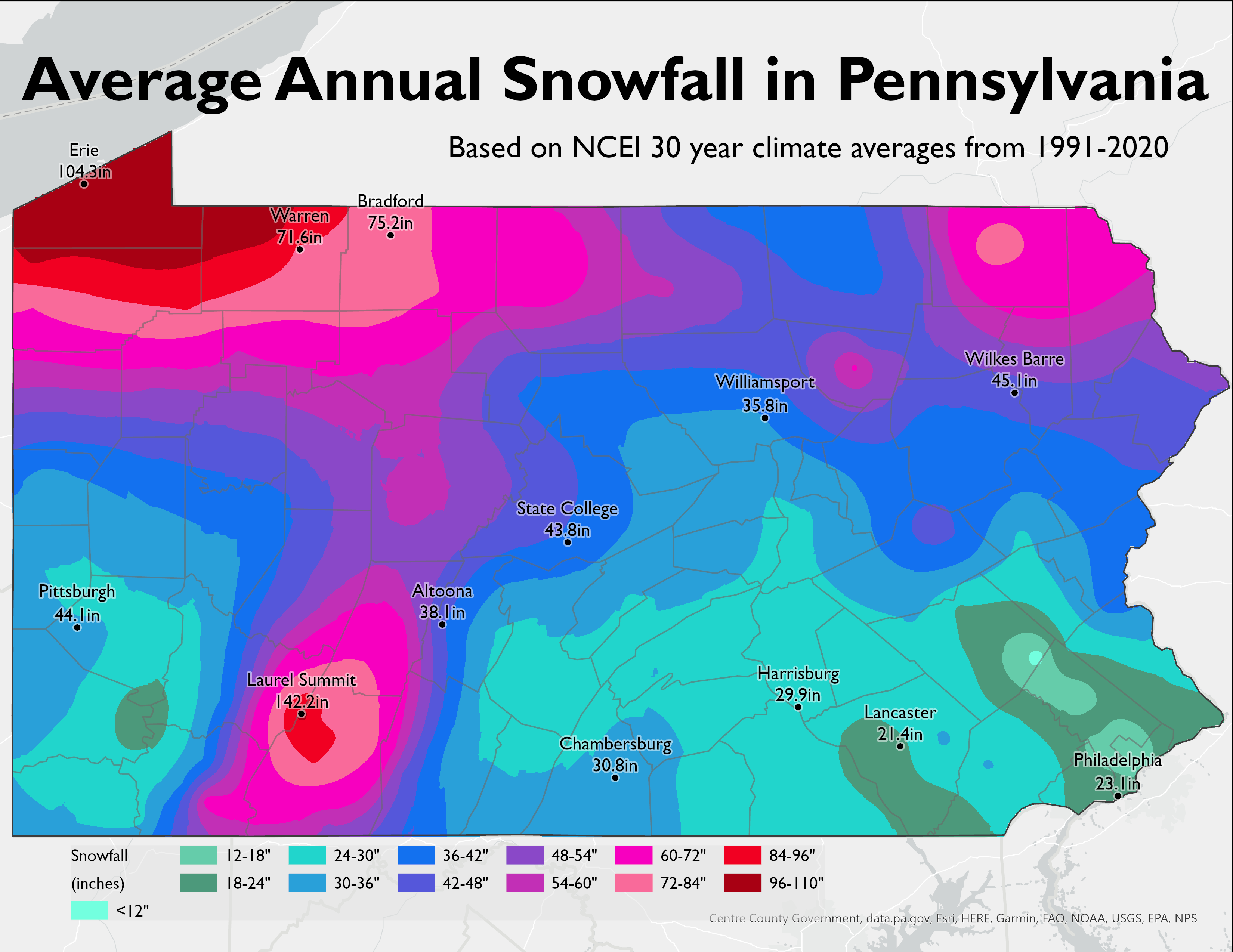
Central PA really isn't a great spot for big snows. They have a longer snow season due to elevation + being inland, but in practice that just means more time to get nuisance nickel and dime events that eventually add up to their modest 30-45 inch averages. They usually need Miller A inland runners to get big storms and those don't come around often. The Poconos are the best spot for snow because they have the elevation while also being far enough east to benefit from more coastal storms. The 2010s were an anomaly with events usually favoring the coast over the interior but I think we're seeing a reversion to the mean now. The problem for Central PA is that they're a bit too interior to benefit from this.
-
1
-
-
1 hour ago, LibertyBell said:
Amazing to see that 6.5 inch total from Allentown and then 41.6 inches at Mt Pocono....what were they smoking?! Clearly not cirrus!
Mount Pocono is at 1900' in elevation compared to 400' for Allentown. Given that all of our events this year featured marginal temps, it's not surprising there's such a large discrepancy.
-
2
-
-
2 minutes ago, LibertyBell said:
Why is this storm SO small and why have storms recently been small like this? January 1996 in this position would have heavy snow all the way back to the midwest.
January 2016 too.
Isn't it a Miller B vs Miller A thing? Big precips field are harder to get with newly redeveloped lows vs older ones that come up from the South and have been pulling in Gulf moisture.
-
2
-
-
Hopefully we can keep getting improvements from the PNA, we could all use this storm after all the misery this winter.
-
1
-
-
3 minutes ago, LibertyBell said:
Lee Goldberg on what happens after the March 13-14 noreaster, he just said "This is winter's last chance to do something. After this big storm, the weather looks benign and will warm up."
The 17th-18th threat is still there on the models. The Euro/EPS are the least enthused about it but they have been trending in a positive direction.
-
1
-
-
If 2018 taught me anything it's that you're not getting meaningful accumulating snow in the City during daytime in March with marginal surface temps. Need that wave on the 17-18th to work out to get anything significant here out of this pattern, since that may have a better antecedent airmass.
-
1
-
-
Very noteworthy signal on the EPS for next weekend:

-
2
-
1
-
-
The 18z NAM run that freaked everyone out had the City at 36+ degrees at 8:00 and above 35 for the whole storm. Seems like that'll bust high.
-
A little sleet mixing in now, we'll see if that continues when precip rates pick up again.
-
Light snow in Turtle Bay.
-
The Signal on the EPS for the 10th is really strong considering the range. The number of sub-980 lows showing up (several 950s and a 948 even!) is especially remarkable.


-
3
-
-
EPS has a 50/50 shot of Central Park getting 3" on Tuesday. What's the exact amount needed to avoid the futility record?
-
GEPS and GEFS are both improved at 12Z for next weekend's storm, significantly so for the GEPS.
-
10 minutes ago, nycwinter said:
uk used to be a very decent model not so much these days..
It was seen as 2nd to the Euro by most for a long time, and the Canadian was hardly discussed. Times change!
April 2023
in New York City Metro
Posted
It's a million times better than the subtropical garbage we're going to get in July and August.