

Gravity Wave
-
Posts
1,165 -
Joined
-
Last visited
Content Type
Profiles
Blogs
Forums
American Weather
Media Demo
Store
Gallery
Posts posted by Gravity Wave
-
-
5 minutes ago, Tatamy said:
Looks like a hail core with the cell just north of Reading.
A couple nasty looking cells there.

-
 1
1
-
-
Here we go.

-
Looks like some action ahead of the main line in SEPA. What could become our MCS is still west of Harrisburg.
-
The severe indices being forecasted for later in PA are actually quite impressive by this region's standards. 3000 CAPE, -9 LI and EHI 6+ in some places. Lapse rates less noteworthy but still decent.
-
Still time for those trailing storm currently over SEPA to turn into something but it looks like the rule that our best severe events happen during Slight risks is going to hold.
-
1
-
-
8 minutes ago, jr461 said:
Been using this mostly but not as good IMO:
The regional on WU still works but you have to really zoom in:
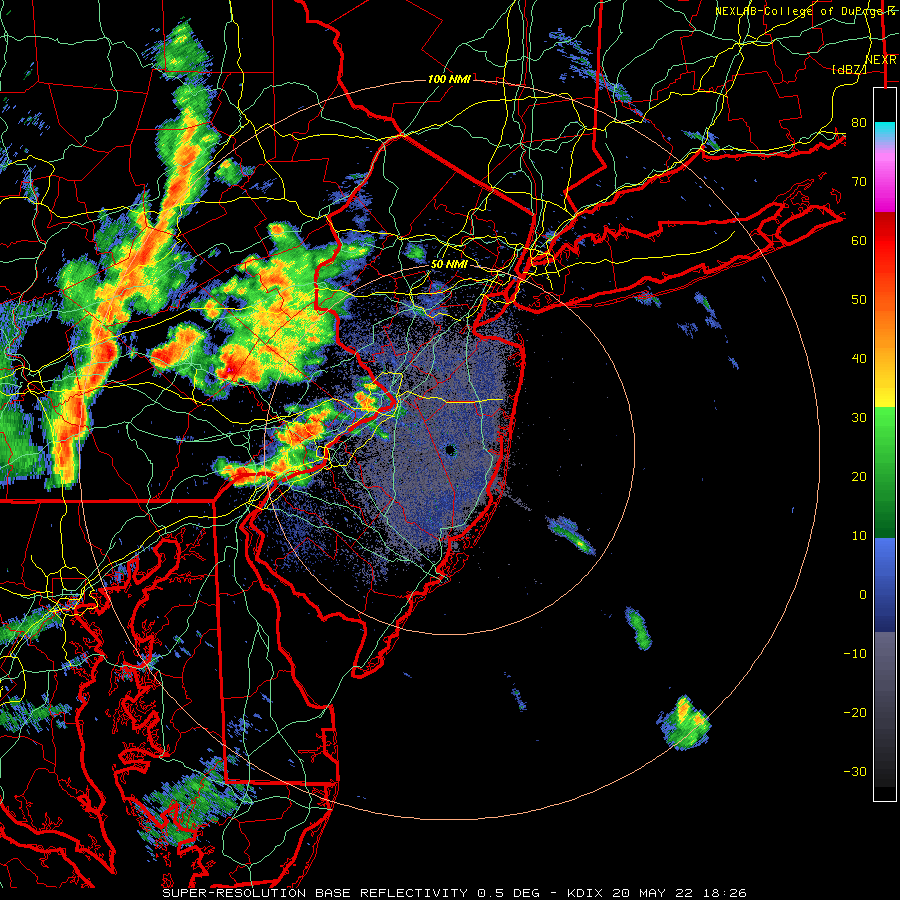
That's the site I use, here's the link for the Fort Dix radar:
https://weather.cod.edu/satrad/nexrad/index.php?parms=DIX-N0Q-0-6-100-usa-rad
-
 2
2
-
-
Pop-up thundershower in Manhattan just now.
-
1
-
-
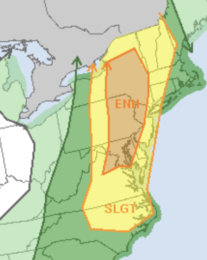
Day 2 Enhanced!
-
43 minutes ago, Tatamy said:
There was no snow squall warning in effect for Schuylkill Cty at the time of the terrible multiple vehicle crash on I81 on Monday morning. Due to the distance between the radar stations situated in this region weather radars cannot see below 9000 feet in that location. The squall was low topped so it was underneath the radar beam. A similar scenario played out in February in that area of PA. I was out in the Scranton region on that day (I drove south on I81 and then onto I476 to the south of there. Elevations range up 2000 ft in that vicinity. The roads had been brined or were dry. Temperatures ranged from 21 to 25 depending on altitude. Penndot had signage posted on the electronic equipment about the potential snow squall hazard. I encountered snow flurries and showers on my drive. This squall that caused the accident was apparently in a narrow streamer that reached SE down to the Philadelphia area. This has been a recurring problem in east central PA and I hope they decide to increase radar coverage in that area.
I remember tracking storms growing up in eastern PA and dealing with a lack of good radar data once they crossed the Susquehanna until they were almost on top of us in the Lehigh Valley, especially if they were approaching from the NW. It's an underrated radar hole, especially when you consider that the areas impacted are quite populated and growing rapidly.
-
1
-
-
3 minutes ago, dmillz25 said:
We have 12” here in bed stuy Brooklyn
Yeah you got a little more banding than we did overnight. The final gradient between NENJ/the LHV and eastern Queens/Nassau is going to be dramatic.
-
1
-
-
2 minutes ago, HVSnowLover said:
Upton did really well with holding their ground with the 7-11 for NYC even with the models going east yesterday. If anything NYC may overperform a little.
Yes, the park has 0.86 LE as of 1:00 so probably 10" there, I'd say we have 8-9" on the East side (due to losing more from melt at the start of the storm). I can't imagine other parts of the city having much less than that.
-
Approaching an inch here, side streets starting to get covered. Snow has gotten appreciably heavier recently, looks like the frontogenesis and banding is getting a little further west than expected.
-
1
-
-
A month of great blocking and we couldn't buy a drop of precip. Now the storm train is rolling and there's an express track from NC out into the Atlantic.
-
1
-
-
Low gets closed off east of the Delmarva Saturday morning. WOW.
-
4
-
-
We have 24-36 hours worth of runs to get that deform band 30 miles west.
-
2
-
-
Hopefully we can get the CMC and UKMET to bite tonight, that would make the GFS a massive outlier.
-
 1
1
-
-
I wonder how much further west we could get this to go. Even small shifts cause huge changes in snow totals.
-
1
-
-
The position of the 700 mb low is perfect for NYC on the NAM.
-
1
-
-
Wow NAM looks great, even if it's at the end of its range.
-
12 minutes ago, LibertyBell said:
That prediction was amazing considering there had been a decade plus of conservative forecasts since the March 2001 bust. I guess the Euro really had much more respect back then.
Yeah the Euro was known by many as Dr. No back in those days, as it had a habit of destroying hopes that had been raised by big solutions that the NAM, GFS and CMC would spit out. Lots of memories of late nights when the other models showed big hits followed by 90 minutes of unbearable tension as everyone waited for the Euro and finally predictable disappointment when it showed a fish storm or a strung-out mess. Few people would ever really get excited about any potential until the Euro was fully onboard, and on the rare occasions when it would agree on a big event it was usually still more stingy in terms of QPF than the others. The numbers it was spitting out for the 2015 storm were shocking and it's a sign of how highly regarded the Euro was at the time that pro mets followed it so confidently when there were some red flags (like the CMC/RGEM being eastern outliers when they were normally the west/amped outliers).
-
3
-
-
3 minutes ago, LibertyBell said:
Wait....March 2001 dropped 5" of back end snow when 2 to 3 ft were predicted, and the first two thirds of it was rain which really sucked. in Jan 2015 there was zero rain, not a single drop and 10 inches of pure snow, that's what makes it better. Also we got our thirty incher the following year, so all was good with the world, right?
I think March 2001 is the bigger bust because if busted for more people (including in SNE where they still got hit but missed out on the gaudy projected totals and blizzard conditions due to a sloppy phase) whereas January 2015 was only really a bust for NYC, most of NJ and the LHV. That being said, 8-10 inches when the NWS was forecasting 24-36 is still a massive failure by any definition.
-
The fact that the Euro didn't even gesture towards a more eastern solution is comforting. Now we need to get the GFS and CMC back on board tomorrow.
-
1
-
1
-
-
3 minutes ago, NJwx85 said:
Miller A's always have a narrow jackpot zone with a major screw zone just to the NW of wherever that sets up. See 1/26-1/27 2015 and to a certain extent 12/26/10 as examples.
It doesn't get any sharper than this.
![Ocean County Remembers the Boxing Day Blizzard of 2010 – 6 Years Later [VIDEO]](https://townsquare.media/site/394/files/2015/12/Dec26_27_2010_NJ_snow.jpg?w=750&q=75)
I was in the one-inch snowhole for that storm (Allentown). WSW for 10-16 turned into a coating of pixie dust. A truly awful memory, and reading the reports in this forum of what was happening 50 miles to my east made everything ten times worse.
-
3
-
-
The Euro control just spat out 2 feet for most of the subforum.
-
7
-
 2
2
-
May 2022
in New York City Metro
Posted
The entire coast from Cape Hatteras to Cape Cod is overdue for an impactful Hurricane strike (I don't really count Sandy, and definitely don't count Irene). Another stretch like 1938-1955 would be ugly.