

Snowlover11
-
Posts
9,844 -
Joined
-
Last visited
Content Type
Profiles
Blogs
Forums
American Weather
Media Demo
Store
Gallery
Everything posted by Snowlover11
-

Extreme Cold, Snow & Sleet: SECS 1/24 - 1/26
Snowlover11 replied to TriPol's topic in New York City Metro
Imo I dont see you flipping to prolonged ZR. Sleet? Sure but thats after 6-8” -
Extreme Cold, Snow & Sleet: SECS 1/24 - 1/26
Snowlover11 replied to TriPol's topic in New York City Metro
The trend hasnt been our friend for the last day. -
Extreme Cold, Snow & Sleet: SECS 1/24 - 1/26
Snowlover11 replied to TriPol's topic in New York City Metro
Apple weather, total joke. -
Extreme Cold, Snow & Sleet: SECS 1/24 - 1/26
Snowlover11 replied to TriPol's topic in New York City Metro
GFS has hardly budged. Either awfully wrong or going to pull a massive W. -
Extreme Cold, Snow & Sleet: SECS 1/24 - 1/26
Snowlover11 replied to TriPol's topic in New York City Metro
So far Nam, Reggie, Icon all shoot mixing into Westchester, Rockland Counties. Definitely a warm push thus far on 0z suite. -
Extreme Cold, Snow & Sleet: SECS 1/24 - 1/26
Snowlover11 replied to TriPol's topic in New York City Metro
Yikes. Toaster bath to start off 0z -
Extreme Cold, Snow & Sleet: SECS 1/24 - 1/26
Snowlover11 replied to TriPol's topic in New York City Metro
It wouldn’t be a winter storm if the NAM doesn’t produce something nuts in the next 24 hrs lol -
Extreme Cold, Snow & Sleet: SECS 1/24 - 1/26
Snowlover11 replied to TriPol's topic in New York City Metro
18z Euro AI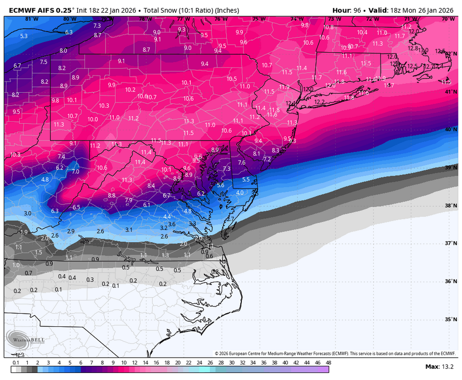
-
Extreme Cold, Snow & Sleet: SECS 1/24 - 1/26
Snowlover11 replied to TriPol's topic in New York City Metro
Gfs is a weenies delight maybe weathergeeks map aint too bad after all -
Extreme Cold, Snow & Sleet: SECS 1/24 - 1/26
Snowlover11 replied to TriPol's topic in New York City Metro
Shows the most so it in fact is correct. in all seriousness its on its own. -
Extreme Cold, Snow & Sleet: SECS 1/24 - 1/26
Snowlover11 replied to TriPol's topic in New York City Metro
If only the GFS could score a win. Crush job. -
Extreme Cold, Snow & Sleet: SECS 1/24 - 1/26
Snowlover11 replied to TriPol's topic in New York City Metro
Way drier than 12z brutal dry slot up to nyc -
Extreme Cold, Snow & Sleet: SECS 1/24 - 1/26
Snowlover11 replied to TriPol's topic in New York City Metro
Always -
Extreme Cold, Snow & Sleet: SECS 1/24 - 1/26
Snowlover11 replied to TriPol's topic in New York City Metro
4-8am Sunday Morning -
Extreme Cold, Snow & Sleet: SECS 1/24 - 1/26
Snowlover11 replied to TriPol's topic in New York City Metro
Yeah can definitely adjust come warning time. -
Extreme Cold, Snow & Sleet: SECS 1/24 - 1/26
Snowlover11 replied to TriPol's topic in New York City Metro
Watches up URGENT - WINTER WEATHER MESSAGE National Weather Service New York NY 1226 PM EST Thu Jan 22 2026 Northern Fairfield-Northern New Haven-Northern Middlesex-Northern New London-Southern Fairfield-Southern New Haven-Southern Middlesex-Southern New London-Western Passaic-Eastern Passaic- Hudson-Western Bergen-Eastern Bergen-Western Essex-Eastern Essex- Western Union-Eastern Union-Orange-Putnam-Rockland-Northern Westchester-Southern Westchester-New York (Manhattan)-Bronx- Richmond (Staten Island)-Kings (Brooklyn)-Northwest Suffolk- Northeast Suffolk-Southwest Suffolk-Southeast Suffolk-Northern Queens-Northern Nassau-Southern Queens-Southern Nassau- 1226 PM EST Thu Jan 22 2026 ...WINTER STORM WATCH IN EFFECT FROM LATE SATURDAY NIGHT THROUGH MONDAY AFTERNOON... * WHAT...Heavy snow possible. Precipitation could mix with sleet and freezing rain for a time Sunday night especially closer to the coast. Potential for snow accumulation of 6 to 12 inches, with localized accumulations over 12 inches possible. * WHERE...All of southeast New York, northeast New Jersey, and southern Connecticut. * WHEN...From late Saturday night through Monday afternoon. * IMPACTS...Roads, and especially bridges and overpasses, will likely become slick and hazardous. Visibilities may drop below one quarter mile in heavy snow. PRECAUTIONARY/PREPAREDNESS ACTIONS... Persons should consider delaying all travel from Sunday into Monday. If travel is absolutely necessary, drive with extreme caution. Make sure your car is winterized and in good working order. Consider taking a winter storm kit along with you, including such items as tire chains, booster cables, flashlight, shovel, blankets and extra clothing. Also take water, a first aid kit, and anything else that would help you survive in case you become stranded. && -
Extreme Cold, Snow & Sleet: SECS 1/24 - 1/26
Snowlover11 replied to TriPol's topic in New York City Metro
So based on what we are seeing expect 0-20”. So much doom and gloom for what’s going to be our biggest storm in years. People need to step off the ledge. We are less than 3 days from flakes flying. -
Extreme Cold, Snow & Sleet: SECS 1/24 - 1/26
Snowlover11 replied to TriPol's topic in New York City Metro
The closet the mixing gets on the gfs atleast based on those images is like toms river. -
Extreme Cold, Snow & Sleet: SECS 1/24 - 1/26
Snowlover11 replied to TriPol's topic in New York City Metro
Plus who the hell takes the 84Hr nam seriously? We never have. Again could be right, could be wrong. I wouldn’t get all caught up on final solutions till 00z friday or even Saturday m. -
Extreme Cold, Snow & Sleet: SECS 1/24 - 1/26
Snowlover11 replied to TriPol's topic in New York City Metro
Lol so we riding the nam? Not saying its wrong but making a call off one model is a bit silly. -
Extreme Cold, Snow & Sleet: SECS 1/24 - 1/26
Snowlover11 replied to TriPol's topic in New York City Metro
Man Nam is torchy. -
Extreme Cold, Snow & Sleet: SECS 1/24 - 1/26
Snowlover11 replied to TriPol's topic in New York City Metro
It wouldn’t be a legit winter storm if we didn’t have a NAMing. -
Extreme Cold, Snow & Sleet: SECS 1/24 - 1/26
Snowlover11 replied to TriPol's topic in New York City Metro
A decent chance, if guidance holds as is, definitely a 60%+ -
Extreme Cold, Snow & Sleet: SECS 1/24 - 1/26
Snowlover11 replied to TriPol's topic in New York City Metro
I dont know why people are panicking. 6z runs looked pretty damn good to me. -
6:30 ish


