Snowlover11
-
Posts
9,844 -
Joined
-
Last visited
Content Type
Profiles
Blogs
Forums
American Weather
Media Demo
Store
Gallery
Everything posted by Snowlover11
-

Extreme Cold, Snow & Sleet: SECS 1/24 - 1/26
Snowlover11 replied to TriPol's topic in New York City Metro
6F -
Meh no idea what to expect could be 8 could be 16”. Rockland is right on the line.
-
Extreme Cold, Snow & Sleet: SECS 1/24 - 1/26
Snowlover11 replied to TriPol's topic in New York City Metro
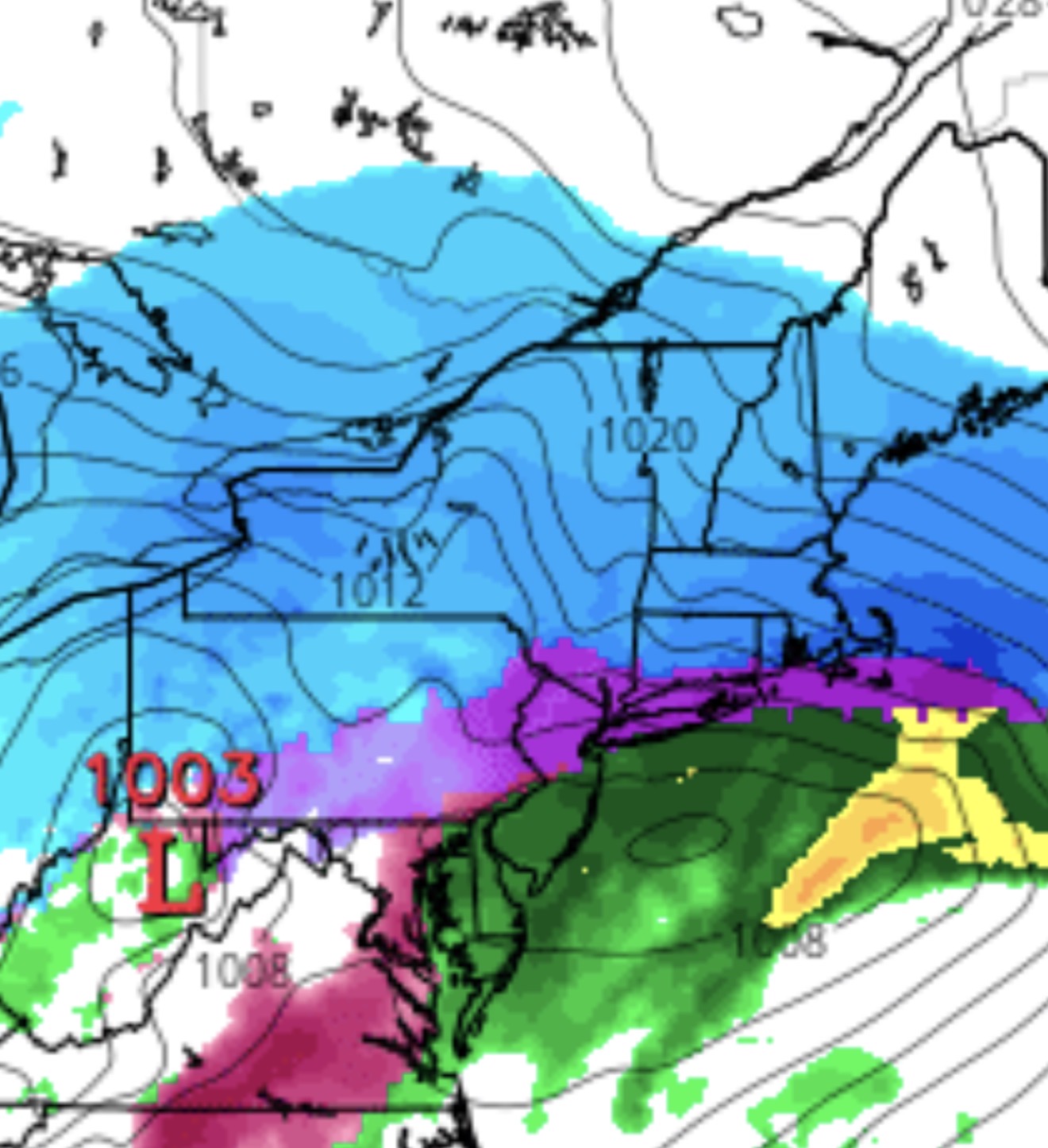
GFS definitely warmer, that mix line literally cuts the city. -
Extreme Cold, Snow & Sleet: SECS 1/24 - 1/26
Snowlover11 replied to TriPol's topic in New York City Metro
6z NAM a tad bit colder for those directly on the edge. Noise at this point. -
Extreme Cold, Snow & Sleet: SECS 1/24 - 1/26
Snowlover11 replied to TriPol's topic in New York City Metro
We are a little over 24 hrs from this baby starting and this place is a morgue. Brutal. Guess it isn’t like the old days. -
Extreme Cold, Snow & Sleet: SECS 1/24 - 1/26
Snowlover11 replied to TriPol's topic in New York City Metro
Might be some virga for an hour or two, but this is going go to come in like a wall. -
Extreme Cold, Snow & Sleet: SECS 1/24 - 1/26
Snowlover11 replied to TriPol's topic in New York City Metro
Wow lol reggie halts the mix at the TZ. -
Usually the winds cap the actual temps from tanking and we would suffer from the wind chill but the actual temperature is tanking and add on the wind chill its nasty. Could be worse we could be in Minneapolis. -45 to -60 wind chills.
-
Extreme Cold, Snow & Sleet: SECS 1/24 - 1/26
Snowlover11 replied to TriPol's topic in New York City Metro
So far the NAM is the warmest model, while others have inched better. Lets see how the GFS,UKMET and EURO do here. -
14F and dropping, It’s brutal outside.
-
Extreme Cold, Snow & Sleet: SECS 1/24 - 1/26
Snowlover11 replied to TriPol's topic in New York City Metro
NAM pushes mixing north of rockland into putnam and orange county. -
Extreme Cold, Snow & Sleet: SECS 1/24 - 1/26
Snowlover11 replied to TriPol's topic in New York City Metro
Meh 0z NAM extremely torchy more so than 18z -
Snow Contest January 25th-26th
Snowlover11 replied to WeatherGeek2025's topic in New York City Metro
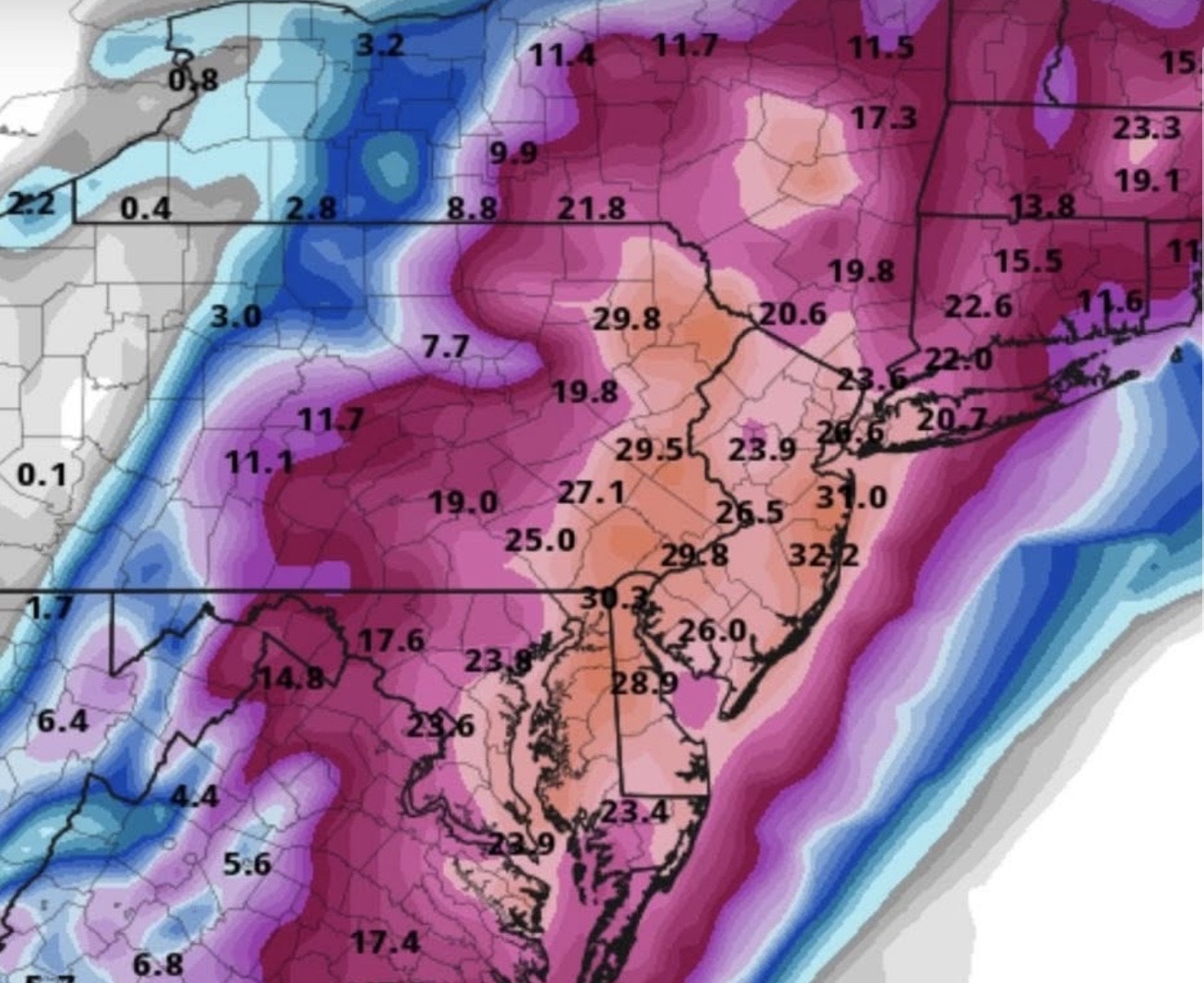
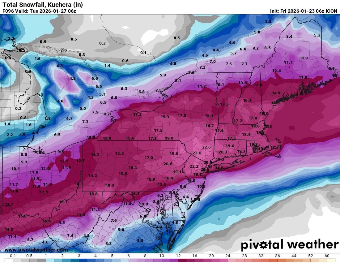
New York City: 9.6” Boston: 16.3” Philadelphia: 7” Washington DC: 6.8” Hartford: 13” Albany: 17” Your city: Nanuet 15” -
Extreme Cold, Snow & Sleet: SECS 1/24 - 1/26
Snowlover11 replied to TriPol's topic in New York City Metro
Starting to see the typical south vs north here. For example it could very well be JFK gets 8, The city 10”, Bronx 12” Westchester 14” etc. -
Extreme Cold, Snow & Sleet: SECS 1/24 - 1/26
Snowlover11 replied to TriPol's topic in New York City Metro
18z definitely not delivering the goods. Yikes the nam shifted like 85 miles with the warm surge. Lol -
Extreme Cold, Snow & Sleet: SECS 1/24 - 1/26
Snowlover11 replied to TriPol's topic in New York City Metro
Winter Storm Warning just issued for 12-16” -
Extreme Cold, Snow & Sleet: SECS 1/24 - 1/26
Snowlover11 replied to TriPol's topic in New York City Metro
A tick, good overall 12z! -
Extreme Cold, Snow & Sleet: SECS 1/24 - 1/26
Snowlover11 replied to TriPol's topic in New York City Metro
Wow. Just woke up to the good ol’ NAM. -
Gfs for next weekend

-
Too good to be true.
-
Extreme Cold, Snow & Sleet: SECS 1/24 - 1/26
Snowlover11 replied to TriPol's topic in New York City Metro
We are still in the flip flop stage. Every model outside the NAM has gotten a bit colder at 6z. -
Extreme Cold, Snow & Sleet: SECS 1/24 - 1/26
Snowlover11 replied to TriPol's topic in New York City Metro
ICON says who’s panicking!
-
Extreme Cold, Snow & Sleet: SECS 1/24 - 1/26
Snowlover11 replied to TriPol's topic in New York City Metro

-
Extreme Cold, Snow & Sleet: SECS 1/24 - 1/26
Snowlover11 replied to TriPol's topic in New York City Metro
6z NAM pretty toasty after a thump. Shoots the mixing all the way to say Poughkeepsie, RT 17 and points east. -
Extreme Cold, Snow & Sleet: SECS 1/24 - 1/26
Snowlover11 replied to TriPol's topic in New York City Metro
Trust me I want the highest totals out of anybody lol, but reality is we have seen a warming trend, again we could be sitting here tomorrow night happier than a pig in shit, it could get worse as well. Hopefully we get the first rather than the latter. See you guys for 6z.