Snowlover11
-
Posts
9,827 -
Joined
-
Last visited
Content Type
Profiles
Blogs
Forums
American Weather
Media Demo
Store
Gallery
Everything posted by Snowlover11
-

Extreme Cold, Snow & Sleet: SECS 1/24 - 1/26
Snowlover11 replied to TriPol's topic in New York City Metro
Not to derail the thread but anyone see the long term GFS? Holy shit! -
Extreme Cold, Snow & Sleet: SECS 1/24 - 1/26
Snowlover11 replied to TriPol's topic in New York City Metro
We dont usually do well with tail end/wrap around snows. Its usually a dump followed by lighter precip mix and shutting off. -
Extreme Cold, Snow & Sleet: SECS 1/24 - 1/26
Snowlover11 replied to TriPol's topic in New York City Metro
Ukmet slaps us with 10-15”+ before a flip at the tail end. -
Extreme Cold, Snow & Sleet: SECS 1/24 - 1/26
Snowlover11 replied to TriPol's topic in New York City Metro
Big storms like this tend to shove the artic high away, not saying this is the case but it does throw up a red flag. We have seen it in the past. -
Extreme Cold, Snow & Sleet: SECS 1/24 - 1/26
Snowlover11 replied to TriPol's topic in New York City Metro
Hazardous Weather Outlook National Weather Service New York NY 121 AM EST Wed Jan 21 2026 CTZ005>012-NJZ002-004-006-103>108-NYZ067>075-078>081-176>179-220630- Northern Fairfield-Northern New Haven-Northern Middlesex- Northern New London-Southern Fairfield-Southern New Haven- Southern Middlesex-Southern New London-Western Passaic- Eastern Passaic-Hudson-Western Bergen-Eastern Bergen-Western Essex- Eastern Essex-Western Union-Eastern Union-Orange-Putnam-Rockland- Northern Westchester-Southern Westchester-New York (Manhattan)-Bronx- Richmond (Staten Island)-Kings (Brooklyn)-Northwest Suffolk- Northeast Suffolk-Southwest Suffolk-Southeast Suffolk- Northern Queens-Northern Nassau-Southern Queens-Southern Nassau- 121 AM EST Wed Jan 21 2026 This Hazardous Weather Outlook is for southern Connecticut, northeast New Jersey and southeast New York. .DAY ONE...Today and tonight. Hazardous weather is not expected at this time. .DAYS TWO THROUGH SEVEN...Thursday through Tuesday. Confidence is increasing in the potential for a significant winter storm to impact the area Sunday into Monday with accumulating snowfall. .SPOTTER INFORMATION STATEMENT... Spotter activation is not expected at this time. && This Hazardous Weather Outlook provides a summary of potential widespread hazardous weather events that may reach NWS warning criteria. Most long fused NWS watches, warnings, and advisories in effect are highlighted. Please refer to the latest NWS forecasts for weather not meeting NWS warning criteria. $$ -
Extreme Cold, Snow & Sleet: SECS 1/24 - 1/26
Snowlover11 replied to TriPol's topic in New York City Metro
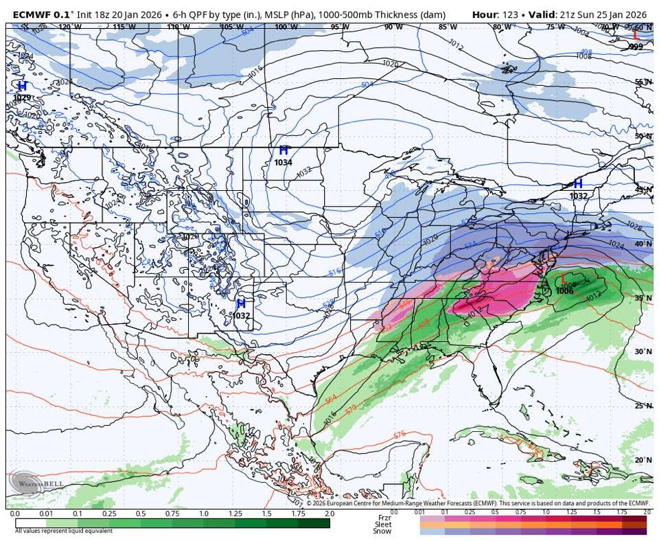
Euro -
Extreme Cold, Snow & Sleet: SECS 1/24 - 1/26
Snowlover11 replied to TriPol's topic in New York City Metro
Lol we went from a southern slider to now the cmc and ukie amping this thing. (Still fine for us.) -
Extreme Cold, Snow & Sleet: SECS 1/24 - 1/26
Snowlover11 replied to TriPol's topic in New York City Metro
That is kuchera. -
Extreme Cold, Snow & Sleet: SECS 1/24 - 1/26
Snowlover11 replied to TriPol's topic in New York City Metro
Best gfs run yet. 10-15” across the board with lollis to 18” -
Extreme Cold, Snow & Sleet: SECS 1/24 - 1/26
Snowlover11 replied to TriPol's topic in New York City Metro
Nice jump north with qpf on AI gfs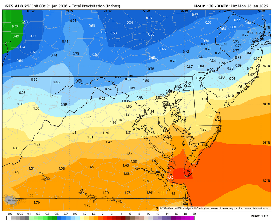

-
Extreme Cold, Snow & Sleet: SECS 1/24 - 1/26
Snowlover11 replied to TriPol's topic in New York City Metro
No, Tomorrow. -
Extreme Cold, Snow & Sleet: SECS 1/24 - 1/26
Snowlover11 replied to TriPol's topic in New York City Metro
Good start on the icon, although we could use another bump or two. most importantly H5 looked better. -
Deep winter about to slap us! 13F currently.
-
Extreme Cold, Snow & Sleet: SECS 1/24 - 1/26
Snowlover11 replied to TriPol's topic in New York City Metro
Euro was about to cook!
-
Extreme Cold, Snow & Sleet: SECS 1/24 - 1/26
Snowlover11 replied to TriPol's topic in New York City Metro
Lol icon moved north, gfs went south basically a flip by both. -
Extreme Cold, Snow & Sleet: SECS 1/24 - 1/26
Snowlover11 replied to TriPol's topic in New York City Metro
Oh Canada!!! -
Storm potential January 17th-18th
Snowlover11 replied to WeatherGeek2025's topic in New York City Metro
Light snow still falling despite nothing on radar. -
Storm potential January 17th-18th
Snowlover11 replied to WeatherGeek2025's topic in New York City Metro
Haven’t measured but 3-4” here. -
Dusting here. Still flurrying.
-
Light snow falling in yonkers
-
That was awesome.
-
Driving home was fun in near zero visibility. Snowpack taking a huge hit.
-
Winter cancelled/uncancelled banter 25/26
Snowlover11 replied to Rjay's topic in New York City Metro
Whenever the next legitimate snow threat happens is going to cause major issues because your average person will say “Oh that last storm was nothing” “the weather professionals were all wrong!” Is going to be out and about. -
Was flurrying cleaning off the car.
-
4.5” Final total 11.6” on the season.